Download
1 / 25
260 likes | 400 Vues
Polar WRF Forecasts on the Arctic System Reanalysis Domain: Atmospheric Hydrologic Cycle. Workshop on Polar Simulations with the Weather Research and Forecasting (WRF) Model Aaron B. Wilson* , David H. Bromwich, and Keith M. Hines Polar Meteorology Group Byrd Polar Research Center

E N D
Polar WRF Forecasts on the Arctic System Reanalysis Domain: Atmospheric Hydrologic Cycle Workshop on Polar Simulations with the Weather Research and Forecasting (WRF) Model Aaron B. Wilson* , David H. Bromwich, and Keith M. Hines Polar Meteorology Group Byrd Polar Research Center The Ohio State University *wilson.1010@buckeyemail.osu.edu
Outline • Motivation • Model Configuration and Domain • Precipitation • Annual, Seasonal, Monthly • Major Arctic River Basins • Clouds • Shortwave and Longwave Radiation • Summary and Conclusions
Motivation • The Arctic System Reanalysis • Expansion of Polar WRF Development • Optimizing performance over the Arctic w/o penalty to other areas • Polar Frontier Project and outreach applications • Evaluation of Polar WRF short-term weather forecasts of the atmospheric hydrologic cycle as a compliment to the surface/upper air analysis • Wilson et al. 2011: JGR doi:10.1029/2010JD015013
Model Configuration • Polar WRF version 3.1.1 with 39 levels in the vertical • Top set at 10 hPa and lowest level centered at 8 m AGL • Physics • WRF Single moment 6-Class* • Grell-Devenyi 3-D Ensemble • RRTM Longwave* • Goddard Shortwave* • MYJ PBL • Noah Land Surface Model with Eta Similarity • Lower Boundary Conditions • SST: NCEP 0.5º RTG_SST Analysis • Sea Ice: Fractional Sea Ice • Bootstrap SSM/I 25 km from NSIDC • Seasonal transition of sea ice albedo • Fixed albedo winter and spring 0.82 • June: Linear decrease in albedo 0.5 by the end of the month representing a mix of bare ice and melt ponds • July: As ponds deepen and become less reflective albedo increases to 0.65 (representing bare ice only) • August 15: 21 day linear increase of albedo to 0.82
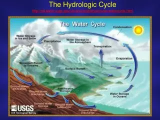
Model Domain and Input Data • Precipitation Data: GHCN, AHCCD, ERA-Interim • Clouds: NCDC, CloudSat/Calipso, MODIS • Radiation: BSRN, ARM, SPRS, FMI • 2-Way Nested Domain • Outer: 180km • Includes most of the NH • Inner: 60km • Includes major river basins flowing through the Arctic • Broad Scale Evaluation • Tractable • NCEP/NCAR 1 x 1 Final Analysis (6-hr) • Forecast mode: 48-hr simulations with hours 24-45 retained for analysis • 240 second time step with 3-hr output • Defined Polar and Mid-Latitude Sub Domains 60º N
Annual Precipitation: Spatial Comparison • Spatially consistent with ERA-Interim Reanalysis • Highest Precipitation totals located throughout the mid-latitudes and sub-polar storm track regions • Dry throughout the Canadian Archipelago • Slightly higher totals in Pacific NW N. America • Both PWRF and ERA-Interim are higher than GPCP here • Polar WRF shows great detail in higher terrain Polar WRF ERA-Interim GPCP
Annual Precipitation • Mid-Latitudes (305): +37.3 mm (+4.6%) • 62% within ±50% (35% within 25%) • NA, Europe, Asian regions: similar results • Polar (78): -58.8 mm (-9.4%) • 69% within ±50% (44% within 25%) • Few stations within 5% • NOT spatially homogenous • Horizontal resolution: a difficult obstacle in grid-point analysis • Large +/- biases in areas of complex terrain • Smooth effects of small scale circulations in area of complex terrain • The fjords of Norway • Canadian Archipelago • Dry throughout the entire year • Mean equatorward water-vapor transport (Serreze et al. 1995) • Winds are inconsistent (southerly)
Monthly Precipitation • Mid-Latitudes warm/cool season discrepancy • Cool months: Negative biases when precipitation synoptically driven • Large (+) Biases in Spring and Summer (Jun: 35.2%, Jul: 16.2%, Aug: 15.2%) • Warm months tied to convection • Polar • Negative throughout the year (-5% to -20%) • Positive bias only in July due to convection near stations in the southern part of boundary
Evaporation • Annual mean 2 m dew point temperature biases in the mid-latitudes led to an investigation of evaporation • ERA-Interim 2 m dew point biases are smaller compared to observations than Polar WRF • Total evaporation on land shows Polar WRF overpredicts evaporation for July compared to ERA-Interim especially for mid-latitudes • Some regions of the Arctic underpredicted and may help explain negative precipitation biases Polar WRF ERA-Interim
Convective Precipitation Sensitivity simulations for July 2007 • 3 Sensitivity Simulations (WRF6C, Morrison, Kain-Fritsch) • Little change in the overall total and convective precipitation (WRF6C, Morrison, Kain-Fritsch) • Grid-nudging of specific humidity towards a drier state in the lower atmosphere • yields negative precipitation bias (25% decrease) and ~1/2 convection • Other areas to investigate include soil moisture and interaction with PBL scheme
Important for the fresh water supply to the Arctic Ocean Headwaters begin as far south as 45ºN representing a strong link between mid-latitude atmospheric processes and effects in the Arctic. Arctic climate system and global ocean circulation Arctic River Basins Ob Yenisei Lena Mackenzie
Precipitation: Arctic River Basins 8 18 +80.9 mm (15%) +204.4 mm (57.5%) 13 5 -29.5 mm (-0.6%) +93.4 mm (24.2% • Convection in spring and summer for the Russian rivers lead to large summer biases • Mackenzie River biases related to smoothed terrain effects • Negative overall precipitation especially in late spring • Southern extent of the region influence by Gulf of Mexico through Great Plains low level jet and cyclogenesis • Single events of > 100 mm are observed (MAGS)
Diurnal 2 m Temperature Cycle • Larger model diurnal 2 m temperature range (i.e. warm day, cool night) suggests too little cloud cover / too thin • Affects other state variables… and must be seen in the cloud fractions and radiation
Cloud Fraction Biases • Estimated cloud fraction based on cloud liquid water and ice (Fogt and Bromwich 2008) • Converted 3-hr observed NCDC cloud categories to decimal value • January: • Positive biases in western Europe and NA associated with storm tracks • July: • Majority of stations reflect negative CF biases • Many stations have < -25% CF compared to observed
Clouds Continued • Model shows (+) CF associated with higher terrain perhaps too strongly • Storm tracks in N. Pacific and N. Atlantic depicted well • North Slope CF reasonably well matched with MODIS and CloudSat/Calipso • No increase in cloudiness adjacent to the coast • Only conservative method yields results that approach observed
Longwave and Shortwave Radiation Biases • Expands previous studies with two additional sites (Abisko and Sodankylä) • Compared with middle months of 4 seasons with July shown here • Negative Longwave Radiation Biases…most significant at 99%. • Positive Shortwave Radiation Biases… most significant at 99%. • Poor longwave correlations/ Good shortwave correlations.
July 2007: Mid-Latitudes • Fort Peck, Montana • Grassy flat location in the northern Great Plains • SW radiation often overpredicted by the model • LW radiation generally underpredicted throughout the month • Area shows 3ºC warm biases consistent with too much SW reaching the surface and a lack of radiative clouds for LW • Note the difference on 1st, 7th, 11th, and 25th
July 2007: Polar • Atqasuk, Alaska • Flat tundra on the North Slope of Alaska (~70 km away from the coast) • SW radiation also overpredicted by the model • LW radiation greatly underpredicted throughout the month • Note large differences around the 10th and 25th but LW also not as tied to SW
July 2007: Polar • Abisko, Sweden • Slightly sloping tundra on the south shore of Lake Abiskojaure with terrain SW increasing rapidly • SW radiation also overpredicted by the model but seems offset slightly by equal/opposite errors • Abisko experiences less cloudy conditions due to down-sloping effect from the higher terrain SW not well represented by model (14th, 17th, and 19th)
Cloud Water/ Cloud Ice • Scatter plots of Model LW vs. Observed Longwave for various model cloud species • (a) Cloud water and/or cloud ice available • (b) No Cloud water or ice • (c) Cloud water regardless of cloud ice • (d) Cloud ice only • Mid-latitudes • LW correlations are strong for all 4 cases • When cloud water or ice is available, model biases are negative • “Model Clear Sky”: Correlations increase and model agrees better with observations • Again, when cloud water is present (c) the model performs worse (Cloud ice has a zero effect on switch in RRTM scheme) • Polar Region • Model LW suffers greatly compared to observations • Apparent insensitivity between cloud water/cloud ice conditions and “clear sky”
Shortwave and Longwave BiasesRevisited…ASR style. • LESS Negative Longwave Radiation Bias: Many still significant • LESS Positive Shortwave Radiation: Fewer significant differences • Improved Longwave correlations/ Mixed Shortwave correlations.
Summary and Future Work • Model • Precipitation • Spatially consistent with ERA-Interim Reanalysis and GPCP • Small Annual (+) Biases in Mid-Latitude, Larger Annual (-) Polar Biases • Large (+) spring and summer biases tied to convection including Russian sector rivers • Related to high evaporation and a moist lower boundary layer • Cloud Fraction • Appears too low based on cloud water and cloud ice calculation • Cloud frequency technique compares better to MODIS and CloudSat/Calipso discrepancies still exist • Radiation • Significant (+) SW Down Biases and (-) LW Biases • Despite cloud water in the model, LW biases are still negative • Insensitivity to cloud water/cloud ice in the polar region (Perhaps biggest concern needed to address in the future) • ASR • Precipitation • Grid Nudging specific humidity decreases convection • Better constrained moisture field in the boundary layer should improve performance • ASR Precipitation needs to be analyzed • Radiation • Improvements in biases for ASR in both SW and LW radiation
Thank You! NSF IPY Grant ARC-0733023 Columbus Zoo and Aquarium