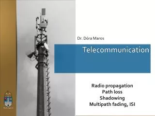
Telecommunication Networks
Telecommunication Networks. Satellite Radiocommunication Systems. Receiver. Adó. Trasmitter. Tipically broadcast networks ( big geographical area , TV, Radio ). Trasmitter. Trasmitter. Receiver. Receiver. Different communication systems with small or big amount of data .

Telecommunication Networks
E N D
Presentation Transcript
TelecommunicationNetworks SatelliteRadiocommunication Systems
Receiver Adó Trasmitter Tipicallybroadcastnetworks (biggeographicalarea, TV, Radio) Trasmitter Trasmitter Receiver Receiver Differentcommunicationsystemswithsmallorbigamount of data. Differentradiofrequencyband, differentapplications. differnetareas Land, orsatelitecommunicationwithdifferenttypes of antennas
SateliteCommunication Earth is coveredbysatelireantennas, fordifferentapplications
Van Allen Radiation Belt Van Allen Radiation Belt The Van Allen radiation belt is a torus of energetic charged particles around Earth, trapped by Earth’s magnetic field. The inner belt consists mostly of protons while the outer belt consists mostly of electrons.
SatelliteOrbits Orbits LEO, LowEarthOrbit: distance200– 1200 (2000) km-re fromtheEarthsurface, mainlycirclebutsomeellipsetoo MEO, MediumEarthOrbit: distance2000–35786 km fromtheEarthsurface, ellipse GEO, GeostationaryOrbit: distance 35786km fromtheEarthsurface Orbitalplanes Middleinclination Polar Equatorial
SatelliteNetworks (GEO) • FSS (Fixed Satellite Service). The transponderreceivesthesignalfromtheEarth, transformsthesignaltoanotherfr. band, amplifiesitand transmitsitto an EarthStation. • ISL (InterSatellit Link). Connectionbetweentosatellites • MSS (Mobile Satellite Service). Connectionbetweenmovingendpointsthroughdifferentsatellites Services: weather, communication, TV-radiobroadcast, amateurradio…
SatelliteNetworks (LEO) • Mobile satellitecommunicationsystems: IRIDIUM, GLOBALSTAR • IRIDIUM: • 66 activesatellites (on 6 orbital • planes) • 6 spare • CoversthewholeEarthsurface • Satelliteson LEO • Distance 780 km • Period 100 minutes • Satellitesconnecteddirectly • onadjacentorbits
SatelliteNetworks (LEO) • GLOBALSTAR: • 48activesatellites (on 8 orbitalplanes, 6 satelliteseach) • 4spare • Coversthe part Earthsurface ( eg. Polarareasarenotcovered) • Satelliteson LEO • Distance 1414 km • Period114.1 minutes • Satellitesarenotconnected directlyonadjacentorbits
GlobalstarConnection Sam Sergei
GPS Systems GPS Global Positioning System The United States' Global Positioning System (GPS) consists of up to 32 MEO satellites in six different orbital planes Operational since 1978 and globally available since 1994, GPS is currently the world's most utilized satellite navigation system. GLONASS, Global'nayaNavigatsionnayaSputnikovayaSistema (GLObalNAvigation Satellite System), Russian, or GLONASS, was a fully functional navigation constellation in 1995. After the collapse of the Soviet Union, it fell into disrepair, leading to gaps in coverage and only partial availability. It was recovered and fully restored in 2011. Galileo European Union and European Space Agency agreed in March 2002 to introduce their own alternative to GPS. The system of 30 MEO satellites was originally scheduled to be operational in 2010. The original year to become operational was 2014.
Theory of Positioning GPS satellites transmit signal information to earth. GPS receivers take this information and use triangulation to calculate the user's exact location. Essentially, the GPS receiver compares the time a signal was transmitted by a satellite with the time it was received. The time difference tells the GPS receiver how far away the satellite is. Now, with distance measurements from a few more satellites, the receiver can determine the user's position and display it on the unit's electronic map.
Theory of Positioning Each GPS satellite sends out a unique code. That code is a series of ones and zeros (Figure 3). The GPS receiver in your car or phone has a copy of each satellite’scode. When GPS signals come in, the receiver electronics has to figure out which satellites sent them. It carefully compares the received GPS signals with the codes for all the satellites it knows about.
GPS Signals C/A codes: civil P codes: military Firstly, the navigation signal (50 Hz) will either modulate with C/A code or P code depending on the type of application. The navigation signal modulated with C/A code will mix with L1 carrier producing a L1 signal. Whereas the navigation signal modulated with P code will mix with both the L1 and L2 carrier produce a L2 signal.These signals contain data like satellite orbits, clock corrections and other system parameters. P codes in the L1 band have a signal power of -163 dBW and a power of -166 dBW in the L2 band. By contrast, the broadcast power for C/A codes in the L1 band is a minimum of -160 dBW on the earth’s surface.
GPS NavigationMessage For C/A codes, the navigation message consists of 25 frames of data, and each frame contains 1500 bits. In addition, each frame is divided into five 300-bit subframes, each subframe contains a unique set of information. Generally, subframes have the following data [2][7]: Subframe 1: Clock correction, accuracy, and health information of satellite Subframes 2-3: The precise orbital parameters used to compute the exact location of each satellite Subframes 4-5: Coarse satellite orbital data, clock correction, and health information
GPS Navigation Data 1) TLM – Telemetry: 30 bits, sent at the beginning of each frame. •It is used for data synchronization and satellite maintenance. They are usually constant for any one satellite for a long period of time. 2) HOW – Handover Word: 30 bits, sent after TLM. It indicates the time at the beginning of the next subframe. •It also contains a sub-frame ID, some flags and parity bits. 3) Ephemeris: It is sent in each frame by each satellite. It may take the GPS receiver up to 30 seconds to acquire Ephemeris. 4) Almanac: It is spread out over all 25 frames of the message. For receiving the complete Almanac, the GPS receiver may need about 12.5 minutes.
GPS Receiver Chips S Price is below 1 Euro