Download
1 / 15
160 likes | 398 Vues
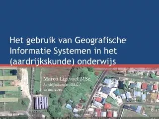
Het gebruik van Geografische Informatie Systemen in het ( aardrijkskunde ) onderwijs. Marco Ligtvoet MSc Aardrijkskunde IOL 14 mei 2010. Wat is een Geografisch Informatie Systeem (GIS)?. GIS- programma’s. ‘ Echte ’ GIS-software ArcGIS GeoMedia

E N D
Het gebruik van GeografischeInformatieSystemen in het (aardrijkskunde) onderwijs Marco LigtvoetMSc Aardrijkskunde IOL 14 mei 2010
GIS-programma’s • ‘Echte’ GIS-software • ArcGIS • GeoMedia • GISviewers • ArcView • Google Earth • Online programma’s • Google Maps • EduGIS
Google Earth • Gratis te downloaden • Interactieve wereldbol • Satellietbeelden • Luchtfoto’s • Kaarten • Andere gegevens (Lagen) • Zelf informatie toe te voegen! • Eenvoudig
Toepassingen in het onderwijs • Gebruik door de docent • Lessen voorbereiden • Illustreren van leerstof • Gebruik door leerlingen/studenten • Onderzoek • Bestaandekaartlagen • Nieuweinformatietoevoegen
Mogelijkhedenzijnonbeperkt? • Computer met internet voor de docent? • Mogelijkhedengebruik beamer? • Computers met internet voorstudenten?
Toepassingbij MO_A Aardrijkskunde • Onderzoeknaarveranderendlandgebruik in de omgeving van het IOL
Enkele Links • http:// earth.google.com • Google Earth homepage • http://maps.google.com • Google maps • http://www.edugis.nl • Educatieve Website met o.a. Google Earth lesmodules • http://gelessons.com • Actuele website met zeerveel GIS-toepassingenvoor het onderwijs. • http://digischool.kennisnet.nl/community_ak/gis • http://www.esrinl.com • Fabrikant van o.a. ArcGIS