Understanding Fault Features and Seismic Activity Along the San Andreas Fault System
180 likes | 295 Vues
Explore the geological features associated with the San Andreas Fault, including fault scarps, steep mountain fronts, offset streams, sag ponds, and changes in rock types. This analysis focuses on St. Louis's seismic lag time of 21 seconds and examines key geological clues that indicate fault lines. By coloring rock types Tc and Tnv, we gain insights into fault movement, including calculating movement speeds since the Eocene epoch. We'll also review the seismicity of key earthquakes, such as Loma Prieta, and their implications for areas like San Jose.

Understanding Fault Features and Seismic Activity Along the San Andreas Fault System
E N D
Presentation Transcript
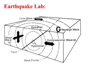
S The lag time for St. Louis is 21 seconds P
Features associated with the San Andreas Fault • Fault Scarps • Steep mountain fronts • Offset streams (Dogleg streams) • Sag ponds and lakes • Valleys in fault zones • Changes in rock type
Offset fence Point Reyes
Fault Scrap Central California scarp Linear valley Linear ridge Offset stream
Spot the clues that would tell a geologist if she was walking in this area that a fault-line is here. Color in rock types Tc,and Tnv What do they tell you? When did these fault-lines roughly last move? Using Tnv, calculate the speed of movement since the middle of the eocene.
Qos Tnv Tnv Tnv
A. Seismicity (1969-89) before Loma Prieta San Jose could be next! B. Loma Prieta earthquake and aftershocks