From vortex initialization to assimilation
From vortex initialization to assimilation. Sharan Majumdar RSMAS / University of Miami JCSDA/HFIP Workshop on Satellite DA in hurricanes, Dec 2-3 2010. To provide accurate initial conditions.

From vortex initialization to assimilation
E N D
Presentation Transcript
From vortex initialization to assimilation Sharan Majumdar RSMAS / University of Miami JCSDA/HFIP Workshop on Satellite DA in hurricanes, Dec 2-3 2010
To provide accurate initial conditions • Structure of vortex should be dynamically and thermodynamically consistent with mechanisms occurring in TC • Specified vortex should be compatible with resolution and physics of prediction model • Need accurate representation of mesoscale structures, not always balanced
Initialization to Assimilation Initialization plus assimilation Assimilation of synthetic / bogus data “Pure” Initialization “Pure”Assimilation GFS (after relocation), ECMWF, EnKF research (Torn, Zhang, AOML, NRL…), 4d-Var GFDL UKMet, NOGAPS, JMA, operational COAMPS-TC, research HWRF, NRL (COAMPS-TC)
The case for assimilation • Direct computation of initial fields based on real data. • Firm theoretical basis. • Advancements in 4d-Var and EnKF (and hybrid techniques). • Initialization requires assumptions on structure via parametric fits to observations or best track; in contrast, assimilation lets full model handle this. • Initialization can be particularly poor for INVESTs / TDs / sheared storms.
The case for initialization • 4d-Var and EnKF at <4 km resolution and high temporal frequency (at least every 3 hours?) are very expensive computationally. • Unclear about dynamical consistency between analyzed vortex in DA and actual TC. • large increments violate theoretical assumptions? • Incorrect balance constraints? • Inaccurate covariance information in DA. • Initialization is relatively cheap and offers some level of dynamical consistency.
Initialization methods • GFDL and HWRF • NRL COAMPS-TC Dynamic Initialization • RSMAS Direct Insertion • Satellite data: initialization or assimilation?
Remove vortex from global analysis. • Compute environmental field. • Spin-up axisymmetric integration of GFDL model, force tangential wind towards observed storm structure. • Compute storm asymmetries determined from vortex fields in previous forecast cycle. • Insert symmetric and asymmetric vortex into environmental field at observed position; rebalance mass field in vortex ENVIRONENTAL FIELD = BASIC FIELD + DISTURBANCE FIELD – GLOBAL VORTEX GFDL
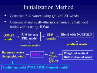
NOGAPS/NCEP analysis NOGAPS/NCEP analysis NOGAPS/NCEP analysis NOGAPS/NCEP analysis NOGAPS/NCEP analysis NOGAPS/NCEP analysis NOGAPS/NCEP analysis NOGAPS/NCEP analysis NOGAPS/NCEP analysis NOGAPS/NCEP analysis Cold Start Cold Start Cold Start Cold Start Cold Start Cold Start Cold Start Cold Start 3DVAR data assimilation 3DVAR data assimilation 3DVAR data assimilation 3DVAR data assimilation 3DVAR data assimilation 3DVAR data assimilation 3DVAR data assimilation 3DVAR data assimilation Remove TC vortex Remove TC vortex Remove TC vortex Remove TC vortex Remove TC vortex Warm Start Warm Start Insert vortex* Insert vortex* Insert vortex* Insert vortex* Run forecast model Run forecast model Run forecast model Tropical Cyclone Dynamic Initialization (TCDI) • *Vortex: • Currently created by hydrostatic version of TCM3 model (future plans will use ideal version of COAMPS-TC) • Idealized simulation • SLP field nudged in over 48 h spin-up run • TCM3 spin-up fields inserted into COAMPS-TC initial conditions within specified radius, followed by blending zone into the environment • For automation and efficiency, master script chooses vortex closest to observed intensity (using pre-existing lookup table of vortices spun-up to different intensities from 900-1010 mb) NRL
3DVAR + Synthetics TCDI The use of TCDI produces a better initial intensity (in both SLP and winds) resulting in a better intensity forecast for Hurricane Bill (2009) NRL
Improved structure using TCDI in COAMPS-TC Example: Choi-Wan (09W) NRL
Potential community TC initialization code (RSMAS) • Parameterized vortex profiles. • Portable code, model-independent, flexible. • Acts as a ‘benchmark’ for initialization and DA methods to surpass • Method: • Vortex removal and relocation similar to GFDL. • Direct insertion of synthetic vortex in gradient + hydrostatic balance. • Fit idealized profile to RMW, VMax, wind decay. • Options for vertical wind profile and water vapor. • Add secondary circulation: mimic boundary layer convergence and upper-level outflow. Rappin et al.
Tropical Storm Category-4 typhoon NATURE NATURE NATURE NATURE BOGUS BOGUS BOGUS BOGUS • Bogus = parameterized profile that best fits corresponding parameters sampled from nature run. • Dynamics in initial conditions here are consistent with dynamics in model and our synthetic ‘nature’ • In reality: initial conditions, model and nature are inconsistent Rappin et al.
Potential use of satellite wind data • Use directly in initialization – e.g. fit of spun-up idealized vortex to satellite winds? • Use to initialize upper-level divergence field? • Derive secondary circulation • Or simply assimilate? • Will DA provide adequate secondary circulation or would the increment be confined to upper levels?
250 hPa divergence and upper-level AMVs Operational Hourly AMVs Rapid-Scan AMVs CIMSS
NOPP/HFIP project (PI: Velden, CIMSS, collaborators: U.Miami, NCAR, NRL, NESDIS, AOML) • Use multiple and integrated satellite data sets at their highest resolution (minimize thinning, maximize information content), in a high-resolution analysis/forecast system for tropical cyclones. • With current satellite data spatial resolutions, a 27/9 km nested WRF framework may be adequate. • Explore first using EnKF within NCAR WRF/DART framework. Then explore Navy COAMPS-TC system. • Seek an optimal assimilation strategy for integrated satellite data, not just one data type.
DA experiments in Year 1 • “Control” dataset prepared, all data excluding satellite radiances. • Special data listed below processed at CIMSS. • Using WRF/EnKF, examining impact of assimilating • Hourly satellite cloud winds • Rapid-scan satellite cloud winds • AIRS T and Q soundings Hui Liu, NCAR
Final thoughts • It has not yet been demonstrated quantitatively that assimilation is superior to initialization. • Lack of peer-reviewed publications on • Critical review of initialization methods • Honest appraisal of DA (Torn 2010 in press) • Relative forecast sensitivity to initial conditions in the storm versus the environment • Require improved understanding of how initialization and DA project analysis onto mechanisms captured in forward model. • Need to understand how mechanisms in forward model project onto reality! • Explore combinations of initialization and DA – exploit their respective strengths in blended product?

