Peters Map!
Peters Map!. Petersmap.com. Who Created it?.

Peters Map!
E N D
Presentation Transcript
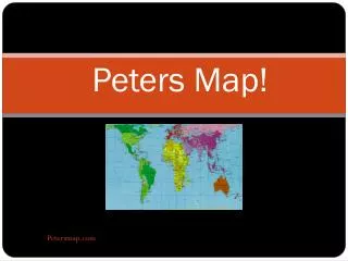
Peters Map! Petersmap.com
Who Created it? • In the year of 1974 cartographer and historian Dr. Arno Peters first introduced the Peters map in a conference in Germany. This map put up a lot of debate and controversy , but still had plenty of adoring fans. By 1983 the first English version of the Peters map was published. Since then this map has broadcasted world wide and is now know by millions of people. Petersmap.com Picture : http://www.newint.org/features/1983/05/01/flat/
The purpose? • The Peters map is an ,almost, area accurate map. It serves the purpose of presenting countries at there correct proportion. The Peters projection map shows a rectangular coordinate system that showed parallel lines of latitude and longitude. All map projections distort the shape of the earth, a sphere, the peters map while also cylindrical, was designed to preserve area rather than bearing. The effect is a map that looks odd, because the shapes are all wrong. Countries near the equator are vertically stretched, while countries near the poles are vertically squished. The areas are accurate, which is fair to the developing countries, but Peters is a terrible projection for representing the world as a whole. http://gis.stackexchange.com/questions/24725/is-the-mercator-projection-or-the-gall-peters-projection-of-the-world-more-accur
Problems with this map? • The problem with peter projection map is that it is more accurate but by being more accurate it gives an unfamiliar look leading people to believe that isn't as accurate as it actually is. This map projection also gives a more distorted look of the Polar Regions making it useless for explorers and people who are interested in the colder areas of the world. http://www.justglobes.co.uk/pages/faqs/peters_projection_maps.html
Benefits? • Peter Map Projection challenged the Mercator Map Projection trying to improve from it, and succeeded. The Peter Map Projection is a more accurate map on distance, shape, and direction of all the countries and body of waters. Even though this is a more realistic map of the world it does not show actual accuracy of countries since you can't change a 3-d image into a 2-d image and still make it perfect. http://www.pinnaclefarms.ca/ORIANAsite/DownsideUp/DownsideUp.html#pet