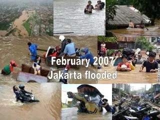
February 2007 Jakarta flooded
200 likes | 359 Vues
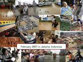
February 2007 Jakarta flooded. Ministry pulls all stops to reduce flood risk City News - February 20, 2007 Jakarta Post.

February 2007 Jakarta flooded
E N D
Presentation Transcript
February 2007 Jakarta flooded
Ministry pulls all stops to reduce flood risk City News - February 20, 2007 Jakarta Post The government has renewed its commitment to expediting the construction of the East Flood Canal and the reforestation of upland areas south of Jakarta. State Minister for the Environment Rachmat Witoelar said the deadline for the completion of the East Flood Canal would be pushed forward to 2008 from 2010. "The government has committed to completing it within 18 months. We also embarked on a massive tree-planting program in Puncak today (Monday)," Rachmat told House of Representatives Commission VII for environmental affairs. He said the government would grant an additional Rp 500 billion in budgetary funds to settle the problem of land acquisition for the project. Only a 7.6-kilometer stretch of the 23.5 km canal has been finished. Sonny Keraf of the Indonesia Democratic Party of Struggle (PDI-P) urged the ministry to be more proactive in resolving environmental issues related to floods or droughts. "The ministry must not be afraid to press the administrations that are violating their own spatial planning regulations. The ministry must also work on a long-term solution to the flood problem," said Sonny, a former minister for the environment. He said Jakarta was overpopulated and immediate action was needed to stop the conversion of green spaces for commercial purposes.
120000 100000 Most changes in 1st decade Settlement Non-vegetation 80000 Non-tree based Tree-based Forest 60000 Area (km2) 40000 20000 1970's 1980's 1990's 2005 1973 2005 Land cover trajectory 100% Most changes in lowlands 80% 60% Percentage 40% 20% 0% 0-100 250-500 750-1000 1250-1500 1750-2000 m Elevation
Three types of knowledge on Watershed function : Hydrologists’ ecological knowledge Local ecological knowledge Public/Policy ecological knowledge
Impacts of HKM Sumber jaya • increased land tenure security, • double local land value, • reduced corruption, • increased income (about 30%, mostly due to reduction of bribes) • increased equity (relative to the in-village resources farmers have), • promoted tree planting/agroforestry, • promoted soil and water conservation, and • gave farmers good reasons to protect remaining natural forest. Source: BASIS (Broadening Access and Strengthening Input Market Systems) project – a collaboration research between ICRAF, MSU (Michigan State University) and IFPRI (International Food Policy Research Institute)
Precipitation = P River flow = Q Evapotranspiration = E Eveg Esoil Eirr Einterc Qquick Qslow precipitation Signal modification along river Einterc Energy-limited Epotential interception Qquick Esoil + Eveg infiltration Qslow 1. Transmit water 2. Buffer peak rain events 3. Release gradually 4. Maintain quality 5. Reduce mass wasting • Q/P=1-(E/P) • QabAvg/PabAvg • Qslow/P = (Pinf – ES+V)/P • Qualout/Qualin • risk Scale dependent
Inputs for pattern analysis: Remote sensing imagery Ground sampling protocols Laboratory data (spectral + ‘functional’) Land use patterns & socio-econ. drivers Issues on ‘sustainable land management’ Key parameters for functional soil & land cover processes, Quantitative performance indicators Land Use scenarios PALA, LEK GIS tools Outputs for process-based models: Waterbalance: E & Q components Hydrograph: peak & baseflows Yields/productivity Watershed function indicators Inputs for process-based models: Vegetation cover/phenology Rainfall, ETpot Topography Soils Plot-level: WaNuLCAS Landscape-level: SWAT,GenRiver, FALLOW, IAHCRES, Enhanced diagnosis LEK validation Science at negotia-tion tables Better-informed decisions Adaptive policies Tradeoff & scenario analysis economic Outputs . for land degradation/suitability analysis: Degradation status, Critical thresholds, Spatial prioritization of rehabilitation interventions analysis Landscape stratification, toposequences, long term dynamics, geomorphology etc.
120 Way Besay, Sumberjaya 100 Flow persistence 0.75 80 60 River yesterday 40 1975 20 1985 1995 0 0 20 40 60 80 100 120 River today
I II III Shade trees, coffee, filter strips prices for inputs & outputs Profitability Wanulcas SoilQ change over time runoff, latflow filter test1 Land cover change: pattern & time course Roads and paths Sub-catchment level model Ricefields as filters test2 ? Catchment / river model Spatial Correlation Rainfall water quality, quantity & timing test3
Layer 1 Layer 2 Layer 3 Layer 4 Zone 4 Zone 3 Zone 2 Zone 1 WaNuLCAS model Lateral inflows Lateral outflows Vertical drainage
Sumber Jaya: Forest earth-worms (Meta-phire spp.) versus ‘invasive exotic’ (Ponto-scolex spp.) in coffee gardens
HKM River quality for hydro-electric Forest edge 2005/6 BASIS CRSP impact study River care Stream users Sumber Jaya 3 nested scales:
‘Protec-tive garden’ Sustainable land use Stakehol-der nego-tiation Watershed management Agroforestry Trees, Soil, Drainage Hydrological Functions Criteria & Indicators
Impacts of HKM Sumber jaya • increased land tenure security, • double local land value, • reduced corruption, • increased income (about 30%, mostly due to reduction of bribes) • increased equity (relative to the in-village resources farmers have), • promoted tree planting/agroforestry, • promoted soil and water conservation, and • gave farmers good reasons to protect remaining natural forest. Source: BASIS (Broadening Access and Strengthening Input Market Systems) project – a collaboration research between ICRAF, MSU (Michigan State University) and IFPRI (International Food Policy Research Institute)