Hurricanes
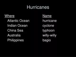
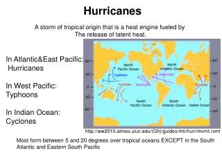
Hurricanes. A storm of tropical origin that is a heat engine fueled by The release of latent heat. In Atlantic&East Pacific: Hurricanes In West Pacific: Typhoons In Indian Ocean: Cyclones. http://ww2010.atmos.uiuc.edu/(Gh)/guides/mtr/hurr/mvmt.rxml.

Hurricanes
E N D
Presentation Transcript
Hurricanes A storm of tropical origin that is a heat engine fueled by The release of latent heat. In Atlantic&East Pacific: Hurricanes In West Pacific: Typhoons In Indian Ocean: Cyclones http://ww2010.atmos.uiuc.edu/(Gh)/guides/mtr/hurr/mvmt.rxml Most form between 5 and 20 degrees over tropical oceans EXCEPT in the South Atlantic and Eastern South Pacific
Atlantic Hurricane Season • Runs from: • J UNE 1 - NOVEMBER 30 • AVERAGE SEASON IN THE ATLANTIC BASIN: • 10 NAMED STORMS • 6 HURRICANE • 3 MAJOR HURRICANES (CATEORY 3 OR GREATER)
Prevailing June Tracks www.nhc.noaa.gov
Prevailing July Tracks www.nhc.noaa.gov
Prevailing August Tracks www.nhc.noaa.gov
Prevailing September Tracks www.nhc.noaa.gov
Prevailing October Tracks www.nhc.noaa.gov
Prevailing November Tracks www.nhc.noaa.gov
Hurricanes Conditions for formation • Initial Disturbance • Warm Sea Surface Temperatures (SSTs) (>80oF) • weak wind shear • High Pressure aloft • Vorticity max near surface • High moisture Initial Disturbance can come from: • Thunderstorms • Easterly waves • Old frontal boundaries
Sea Surface Temperatures (SSTs) From http://weather.unisys.com/surface/sst.html
Vorticity from http://cimss.ssec.wisc.edu/tropic/real-time/atlantic/winds/wg8vor4.html
Wind Shear is the change in Wind’s Direction or speed with height www.weatherquestions.com
The next slides are examples from Hurricane Wilma-shear tendency and the ULdiv
Hurricanes Stages of Development 1.Tropical Wave -an easterly moving trough of low pressure http://people.cas.sc.edu/carbone/modules/mods4car/tropcycl/pages/easterlywave.html
Hurricanes Stages of Development • 2. Tropical Disturbance • a tropical weather system of organized convection, 100-300nm in diameter, that has been organized for 24hours - large cluster of thunderstorm activity
Hurricanes Stages of Development • 3. Tropical Depression • -Tropical Cyclone in which maximum sustained • winds are 38 mph or less • – the tropical system is numbered. • NHC begins to issue advisories
Hurricanes Stages of Development • 4. Tropical Storm • -Tropical Cyclone in which maximum • sustained winds are between 39 mph and 73 mph. • -Tropical Storm is named
Hurricanes Stages of Development 5. Hurricane -category based on The Saffir-Simpson Scale
Hurricanes Stages of Development A storm will DECAY if: • Move over cooler ocean waters • Move onto land • Wind shear • Dry air in the mid or low levels
Hurricanes Structure How does Pressure, Temperature, Rainfall, and Wind Change as you pass through a storm? Cirrus shield
Hurricane Detection & monitoring Tropical Prediction Center (TPC) is responsible for issuing watches, warnings, Forecasts and analysis of hazardous weather in the tropics. The National Hurricane Center (NHC) for the Atlantic, Carribean, Gulf of Mexico, and the Eastern Pacific Geostationary satellites Reconnaissance Aircraft- USAF C-130 , NOAA P-3, & Gulfstream-4 Jet Aircraft Coastal Radars Ships Buoys
53rd Weather Reconnaissance Squadron 403rd Wing, Air Force Reserve Command, Keesler AFB, Biloxi, MS Alpha Pattern
NOAA Aircraft Operations Center MacDill AFB, Tampa, FL
New Technology An unmanned hurricane hunter… UAV: Aerosonde Safety: It can fly into areas too risky for the manned hurricane hunters Long endurance: Flew across the Atlantic Ocean in 27 hours on 1.5gal.of fuel Economical: Made world record when flew for 38 straight hours before refueling
Types of Hurricane Forecasts • Seasonal vs. Event • Seasonal - Forecasts for amount of activity in upcoming season and further • Bill Gray - Colorado State University • Jim Elsner- Florida State University • Event - Forecasts produced for individual system(s) • We’ll focus on event forecasts
Hurricane Forecasting • Numerical Models: • Data collected from aircraft and satellites are used to initialize models • Many different models are used to provide a statistical strike probability • Uncertainty: • Poor initialization due to lack of data • Differing ways these models incorporate physical processes • Different ways models are constructed
Katrina 9 Apr. 2007
Hurricane Track & Intensity The environmental flow has the most influence over the track of a storm http://www.nhc.noaa.gov/HAW2/english/kids/movncane.htm Intensity is affected by the interactions occurring within the storm -ocean evaporation -latent heat release -thunderstorm formation -amount of outflow aloft -amount of windshear
Hurricanes and El Nino El Niño (Spanish name for the male child), initially referred to a weak, warm current appearing annually around Christmas time along the coast of Ecuador and Peru and lasting only a few weeks to a month or more