Download
1 / 27
270 likes | 429 Vues
National Spatial Data Infrastructure (NSDI) in the United States. Kenneth R. McDonald NASA Goddard Space Flight Center ken.mcdonald@gsfc.nasa.gov from a presentation by: Mark Reichardt Federal Geographic Data Committee mreichardt@usgs.gov. Agenda. History of NSDI in the U.S.

E N D
National Spatial Data Infrastructure (NSDI) in the United States Kenneth R. McDonald NASA Goddard Space Flight Center ken.mcdonald@gsfc.nasa.gov from a presentation by: Mark Reichardt Federal Geographic Data Committee mreichardt@usgs.gov
Agenda • History of NSDI in the U.S. • Current Status • Next Steps • Towards a Global Infrastructure
Genesis of the National Spatial Data Infrastructure • Since late 1950’s federal emphasis to review spatial data functions across government (reduce cost, redundancy) • OMB Circular A-16 created to address mapping, surveying and related activities across the federal government • Federal Interagency Coordinating Committee on Digital Cartographic created under OMB directive in 1983 • Federal Geographic Data Committee formalized in 1990 to coordinate federal geospatial data activities throughout federal government and with other national interests (revision of OMB Circular A-16) • National Performance Review endorses a more formal spatial data infrastructure initiative (1993)
Federal Geographic Data Committee • Created under a revision to OMB Circular A-16 to coordinate geospatial activities across government • Representation: • 17 Cabinet and Executive Level Agencies • Numerous Stakeholder Members • Chaired by Secretary Babbitt • FGDC Staff supports operations, administered through the USGS
Genesis of Spatial Data Infrastructure in the U.S. • National Spatial Data Infrastructure formed by Presidential Executive Order 12906 (1994) • Emergence of Regional, and Global SDI initiatives (1996 and on)
The Vision of the NSDI • Current and accurate geospatial data should be: • Readily available: • locally • nationally • globally • To contribute to: • economic growth • environmental quality • social progress
Clearinghouse (catalog) Metadata GEOdata Framework Standards Core NSDI Components Partnerships
A Network of NSDI Organizations VI National League of Cities National Association of Counties Intertribal GIS Council University Consortium on GI Sciences Open GIS Consortium FGDC National States Geographic Information Council International City / County Managers Association
Metadata NSDI Progress:Metadata • FGDC Metadata Standard in wide use at national, state, local levels • ISO TC-211 working towards an International Metadata Standard (second draft is in review) • FGDC endorses ISO metadata standard • FGDC will develop an ISO metadata standard implementation strategy and training
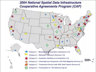
Cooperative Agreements Program Participants State government Academic institutions Federal agencies County & city government Regional organizations Tribal government Private business Requirements Cooperative Agreement Partnership/collaboration In-kind funding match Sustainable projects Applied projects
CAP projects (1994-1999) • clearinghouse implementations • metadata training • metadata thematic implementations • metadata tool development • educational outreach • framework implementations • standards development & implementation • establishment of coordination groups • web mapping testbed software development • U.S & Canadian collaboration
1999 Geodata ForumNational Assessment of the NSDI • NSDI progress and future examined at recent Geodata Forum • 460 industry, government, academia, international attendees • Identified key recommendations to enhance the NSDI • Growing Congressional support for NSDI, first formal hearing held on GIS Policy
Expanding Emphasis Areas for NSDI Community Applications Increase Data Sharing / Discovery Through Standards Open Geoprocessing Interfaces Resources Education & Outreach Increased Emphasis For Decision Support Systems Additional Federal Community Incentives Establish Means For Sharing Best Practices Through NSDI Interoperability & Integration Testbeds Publish Funding Mechanisms and Options Data Registry For Requirements Educational Experiences At All Grade Levels Document Case Studies More Flexible, Broadly Represented Organization Better Understand Economic Dynamics Of Private and Federal Sectors NSDI As A National Objective Through Legislation Update NSDI Strategic Direction Increase GI Sciences Training Locally Independent, Regionally Coordinated Processes National Leadership
Clearinghouse (catalog) Metadata GEOdata Framework Standards Expanded Emphasis for NSDI Community Applications Education and Outreach Expanded Resources National Leadership / Global Partnerships
Community Applications • Increased focus on interoperability testbeds and community applications • FGDC Cooperative Agreements Program • Community Demonstration Projects • Disaster mitigation, response, recovery • Open GIS Consortium Web Mapping Testbed • Digital Earth
Clearinghouse (catalog) Metadata GEOdata Framework Standards NSDI / Digital Earth Relationships • Community End Use Applications • Emphasis on focused research, funding, and • collaborative partnerships to resolve gaps \ • issues • Ensure a sustainable DE marketplace Community Applications National Leadership / Organization • NSDI and GSDI to provide the core • infrastructure • NSDI & DE establish collaborative environment for a complete delivery system Outreach and Educations SDI Resources • Goal: DE & NSDI provide leadership for • nationally consistent capability for new • multi-dimensional representations of our planet
Exploring Next Steps for Digital Earth and NSDI • Explore the alignment of Digital Earth with the FGDC • Steering Group • National Geodata Organization Initiative • Create pervasive communications links so that NSDI/GSDI and Digital Earth vision and programmatics are understood.
Expanded Resources • NSDI Financing Study • Potential financing mechanisms (pooled loans) and • Data Consortia (regional, industry, topic) to build and manage geospatial data • Underwritten to • Protect open access to federal data • Encourage private sector revenue from value added activities • Require metadata, data, technology standards
Education and Outreach • Increased emphasis on case studies and proven practices • Partnerships with Digital Earth Initiative • DEVELOP (College and HS level, increase curriculum focus on DE and geospatial) • Museums (Smithsonian, Science Museum of Minnesota, American Museum Natural History) • E-theater (NASA) • GLOBE (9,000 K-12 students collecting Global Change Research information)
National Organization • New flexible, broadly represented national organization • Broader private sector involvement, expanded federal commitments • Defined national governance structure • Design team working the plan – October 2000 target date • FGDC continues with federal focus • Congressional interest in Legislation to strengthen NSDI Executive Order
International Activities • Nation to nation collaborative activities • Global Spatial Data Infrastructure • Regional Committees for SDI • International Standards Development • Survey of SDI’s
FGDC International Policy Statement • Acknowledges local, national, regional, global perspectives and needs for SDI • Identifies a FGDC staff position • Emphasizes collaboration between nations, Regional and Global SDI • Issued March 2000
Node Node Node Node Node Node FGDC Node Node Node CEONet Node Node Node GSDI: Global Reach On the Way Clearinghouse Sites Gateways ASDD Web Client Others
Tomorrow: A Global Spatial Data Infrastructure Enabled Through Partnerships, Standards, Technology Users s s s Businesses Consumers Government Internet • E-Commerce • Authentication • Other Web-Enabled Services Clearinghouse Service Map Catalog Services Services Registry Internet Registered Data Servers Metadata Metadata Metadata Metadata Metadata Metadata Metadata Imagery Elevation Hydrography Demographics Health Geodetic Control Transportation Economic Environment Crime
Additional Information • www.fgdc.gov Federal Geographic Data Committee • www.spatial.maine.edu/ Survey of SDI’s ~onsrud/GSDI.htm • www.gsdi.org Global Spatial Data Infrastructure • www.nbii.gov National Biological Information Infrastructure