Download
1 / 19
230 likes | 482 Vues
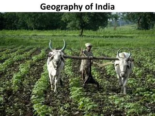
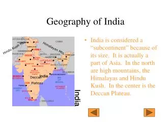
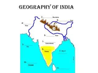
Geography of India. As we go through the PowerPoint…. Label the geographic features of India on your map (#1-10) Answer the questions on the back of your map (highlighted in red). India is located in Southern Asia. 1- Indian Subcontinent. Label the Indian Subcontinent on your map

E N D
As we go through the PowerPoint… • Label the geographic features of India on your map (#1-10) • Answer the questions on the back of your map (highlighted in red)
1- Indian Subcontinent • Label the Indian Subcontinent on your map • Scientists believe that Pangea broke apart into separate continents millions of years ago • About 10 million years ago, the Indian Subcontinent and Asia collided
2 - Himalayan Mountains • The Himalayan Mountains were created by the collision • The plates are still running into each other and the Mountain Range continues to rise • It is the tallest mountain range in the world • The top 98 out of 100 tallest mountains in the world
3- Mt. Everest • The tallest mountain in the world • 29,029 Feet tall (Almost 6 miles high) • That’s 20 Empire State Buildings stacked on top of each other • It is still growing at a rate of 1 inch every 5 years
Over 200 people have died trying to climb the mountain. Climbing Mt. Everest… A base camp on Mt. Everest DEATH ZONE - Above 26,000 feet, climbers must use oxygen tanks because the air is so thin. Edmund Hillary and Tenzing Norgay became the first people to reach the summit in 1953.
Rivers • As the snow and ice in the Himalayas melts, small streams form • Slowly, streams start to meet and combine, forming rivers • These rivers move downhill and gather more force as more streams empty into the river
4- Indus River • Located in modern-day Pakistan • Starts in the Himalayas and empties into the Arabian Sea • This is where the Indus Valley Civilization originated
6- Ganges River • Located in modern-day India and Bangladesh • The most populated river in the world • 400 million people live along the Ganges • Empties into the Bay of Bengal
8- Brahmaputra River • Combines with the Ganges River and empties into the Bay of Bengal • The two rivers create a river delta that is very fertile in Bangladesh
9- Deccan Plateau • Large plateau in southern India. • Plateau- A large raised area of mostly flat, level land
10-Indian Ocean • 3rd largest ocean • Covers 20% of the world’s water surface • Borders Africa, Asia, and Australia
11- Sri Lanka • An island country off the southeastern coast of India • One of the world’s largest tea and coffee producers
Reminder! • Please keep this handout in the social studies section of your binder! • Vocabulary Flash Cards are due on Wednesday 12/11