Download
1 / 15
170 likes | 371 Vues
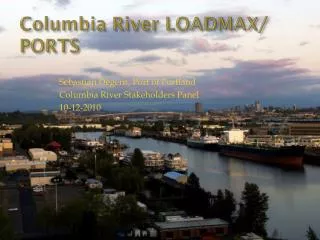
Columbia River LOADMAX/ PORTS. Sebastian Degens, Port of Portland Columbia River Stakeholders Panel 10-12-2010. Loadmax System Overview. LOADMAX provides the maritime industry with real-time and forecast river level data Data is used to assist in making vessel loading and sailing decisions

E N D
Columbia River LOADMAX/ PORTS Sebastian Degens, Port of Portland Columbia River Stakeholders Panel 10-12-2010
Loadmax System Overview • LOADMAX provides the maritime industry with real-time and forecast river level data • Data is used to assist in making vessel loading and sailing decisions • LOADMAX is a cooperative effort between Port of Portland & NW River Forecast Center, National Ocean Service/ PORTS • LOADMAX first deployed in 1984/85, became NOAA PORTS system in 2006/07
Existing Stations Skamokawa Tide Station Beaver Tide Station Longview Tide Station Hammond Tide Station Astoria Tide Station Wauna Tide Station St. Helens Tide Station Vancouver Tide Station Portland Tide Station (Morrison Bridge)
What is a foot of draft worth? • One foot vessel draft = 2,000 tons of cargo, valued at $180,000 • Investment in Columbia River Deepening was $66 million per foot • NOAA Study Estimates value of river level reporting system at $6.4 million/year
2010 Lower Columbia Low Flows • Drought results in fewer sailing windows & draft restrictions The Dalles Jan-Jul Volume Fcst 2001(JUL/14) 1973(SEP) VANW1 -.74 ft -.7 PRTO3 -.58 ft NWS ~ NorthWest River Forecast
Actions to deal with Low Water • Disseminating the information for use within the maritime industry and other stakeholders in a timely manner • Advancing bathymetric surveys • Increasing the frequency of surveys • Advancing the timing of dredging, obstruction removal & other berth maintenance • Coordinating to assure the availability of dredge capability
New Developments: • 24 hour local response service through Merchants Exchange switchboard • Long-Term low flow forecast annually • New Gauge under development at Hammond (RM 8.5)
Suggestions for Improvement: • Greater reliability of the Voice Data Response system • Implement the AIS features for the data delivery shipboard • Recognize that system is being used 24/7 by maritime industry