Constructing cross sections
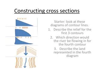
Constructing cross sections. Starter: look at these diagrams of contour lines. Describe the relief for the first 3 contours Which direction would the river be flowing in for the fourth contour Describe the land represented in the fourth diagram.

Constructing cross sections
E N D
Presentation Transcript
Constructing cross sections Starter: look at these diagrams of contour lines. Describe the relief for the first 3 contours Which direction would the river be flowing in for the fourth contour Describe the land represented in the fourth diagram
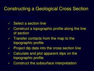
Look at this sketch of the cross section between 237408 and 244418 June 2011 map • Where’s the: • Road • Railway tunnel • River • Non coniferous wood • Church • Settlement • Why do you think the road and the settlement are located in this place?
CHALLENGE!!!! • Create a cross section graph going from 585620 to 585670 • You will have to enlarge your scale to fit it appropriately onto a graph QUESTIONS:- what type of contours can be seen? - Name different land uses for this hill - Which direction is the river in grid square 5865 flowing in?
Use the skills text book pg 54,55 qs 1,2,3,,6 Constructing contours • Place the edge of a piece of paper along the centre of a contour. • Mark the heights of the contour lines where the paper crosses them. This is usually done by putting a small line on a piece of paper and noting down the height at that point. Also mark the spot height at the top. • Remove the piece of paper with the location of the contour lines and the heights marked on it. Place it on a piece of graph paper. Work out an appropriate scale for the y- axis and draw it on the graph paper. Mark the heights at the correct location. • Join up the crosses to show the cross-section of your hill
You will have to describe the shape of the land and complete a contour graph showing the cross section
Recap… Write down 4 physical features you need to describe when describing O.S. maps Write down 3 Human features you need to describe when describing O.S. maps
The site, situation and shape of settlements Site: the land on which a settlement is built, described in terms of its physical characteristics. S – Shelter from strong winds and storms H – Height above sea level A – aspect – the way that the slope faces W – water supply L – land that the settlement is built on such as above the floodplain, fertile land, type of slope Situation: the settlement’s location in relation to other settlements, rivers, relief features, transport etc. P – places A – accessibility R – relief C – communications Definition of site and situation?
True or False? • On a 1: 50 000 O.S. map the distance between contour lines in 10m • Shading is used to show different heights on relief maps • A blue square will show a triangulation pillar • Contours further apart are steeper • You can tell whether a hill is concave or convex just by looking at an O.S. map Exam practice
Uniform slope. Contours decrease ……….. The distance between the contour lines is the ……….. all the way down the slope. Contour patterns Convex slope. Contour lines are ………… together at the bottom of the slope. This means that the height is increasing quickly because the slope is ………….. The lines gradually become further apart towards the …………. of the slope. This is a concave slope. The contour lines are ………..apart at the bottom of the slope. This means that the height is increasing slowly and the slope is ……... The lines gradually become closer together towards the top of the slope. This means that the height is increasing more quickly and that the slope is …………. This is a V shaped valley. The distance between the contours is ……….meaning that the valley sides will have an even slope. There is no ……….. land by the side of the river. The V of the contour always points ………... This is a U-shaped valley. The distance between the contours is regular, meaning that the valley sides will have an even slope. The contours increase quickly, meaning that the sides of the valley are ………. There is an areas of ……… land by the side of the river shown by the lack of ………….. The contour lines of not cross the river for many km, it is therefore difficult to ascertain the direction of flow.
Uniform slope. Contours decrease evenly. The distance between the contour lines is the same all the way down the slope. Convex slope. Contour lines are closer together at the bottom of the slope. This means that the height is increasing quickly because the slope is steep. The lines gradually become further apart towards the top of the slope. This is a concave slope. The contour lines are further apart at the bottom of the slope. This means that the height is increasing slowly and the slope is gentle. The lines gradually become closer together towards the top of the slope. This means that the height is increasing more quickly and that the slope is steeper. This is a V shaped valley. The distance between the contours is regular, meaning that the valley sides will have an even slope. There is no flat land by the side of the river. The V of the contour always points upstream. This is a U-shaped valley. The distance between the contours is regular, meaning that the valley sides will have an even slope. The contours increase quickly, meaning that the sides of the valley are steep. There is an areas of flat land by the side of the river shown by the lack of contour lines. The contour lines of not cross the river for many km, it is therefore difficult to ascertain the direction of flow.
Describing Relief • True or False? • On a 1: 50 000 O.S. map the distance between contour lines in 10m • Shading is used to show different heights on relief maps • A blue square will show a triangulation pillar • Contours further apart are steeper • You can tell whether a hill is concave or convex just by looking at an O.S. map
Using map on page 39 • Using the key terms you’ve just learnt describe the relief in: • 6131 • 6535 • 6431 • 6529 • Give the 6 figure grid reference for the highest point in square 6634. • What is the height of this point? • Compare the relief of 6333 and 5929. • Answer the question on page 219 of green book
Cross section • June 2011 • June 2013
Look at this sketch of the cross section between 237408 and 244418 June 2011 map • Where’s the: • Road • Railway tunnel • River • Non coniferous wood • Church • Settlement • Why do you think the road and the settlement are located in this place?
CHALLENGE!!!! • Create a cross section graph going from 585620 to 585670 • You will have to enlarge your scale to fit it appropriately onto a graph QUESTIONS:- what type of contours can be seen? - Name different land uses for this hill - Which direction is the river in grid square 5865 flowing in?
http://www.geograph.org.uk/photo/2648739 • Claughton moor