Download
1 / 87
870 likes | 1.07k Vues
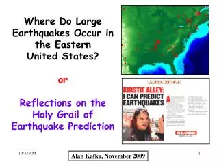
Where Do Large Earthquakes Occur in the Eastern United States? or Reflections on the Holy Grail of Earthquake Prediction. Alan Kafka, November 2009. “… she gets her premonitions from something in the air…”.

E N D
Where Do Large Earthquakes Occur in the Eastern United States? or Reflections on the Holy Grail of Earthquake Prediction Alan Kafka, November 2009
“Since my first attachment to seismology, I have had a horror of predictions and of predictors. Journalists and the general public rush to any suggestion of earthquake prediction like hogs toward a full trough.” - Charles Richter (1977)
My current opinion on earthquake prediction: Given the current state of knowledge in seismology, most (probably all?) specific predictions that are publicly announced are misleading and are often scientifically irresponsible. However, earthquake forecasting (at some level of detail) is quite realistic, and can be scientifically responsible.
Earthquake Prediction • vs. • Earthquake Forecasting • Earthquake Prediction = a short-term (hours to days) statement that an earthquake will occur at a given location. • Earthquake Forecast = a long term (years to decades) statement of the probability of an earthquake in a region (or the probability of one or more earthquakes in a region).
Where Do Large Earthquakes Occur in the Eastern United States? 1700-2008 (Magnitude 5.0-7.4)
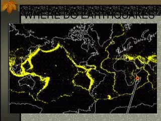
PlateTectonics Earthquakes correlated with: * Mid-Ocean Ridges * Fracture Zones * Ocean Trenches Earthquakes 1980-2001 (NEIC, M5)
Northeastern United States Eastern United States USGS 1700-2008, Magnitude 5.0-7.4 Weston Observatory 1568 – November 2009
1975-2004 (M3) New England Seismic Network Weston Observatory Boston College Magnitude 4.2 earthquake (10/03/06) in Bar Harbor, ME generated ground shaking that caused rockfalls in Acadia National Park. From Ebel et al. (2007)
From: Ebel (2006) Cape Ann, MA Earthquake November 18, 1755 Magnitude 5.9-6.2* V VII VI IV VII * MLg 6.2, M 5.9
Woodcut illustration showing damage to Boston, MA, during the Cape Ann earthquake of November 18, 1755. Shaking was strongest northeast of Boston. The earthquake caused considerable damage in Boston, knocking down or damaging as many as 1,600 chimneys and collapsing brick walls of several buildings. Image from National Information Service for Earthquake Engineering, University of California, Berkeley.
1811 - New Madrid, MO Magnitude has been estimated to be as high as 8.1 and as low as 7.2 From Hough et al. (2000) and Hough (2002)
PlateTectonics Earthquakes correlated with: * Mid-Ocean Ridges * Fracture Zones * Ocean Trenches Earthquakes 1980-2001 (NEIC, M5)
Dear Professor Kafka: I work upstairs, in the Fine Arts Dept. My husband and I recently purchased a home in the western part of Framingham, just south of the intersection of the Mass. Pike and route 9. We have always carried earthquake insurance in the past, but our new house is masonry, and the cost of earthquake coverage is high - close to $400/year! Of course, because it's masonry, earthquake damage could be catastrophic. We are trying to make an informed decision. I went down to the third floor and looked at the Geological Map of Massachusetts; I saw plenty of fault lines in our area (as well as everywhere!), but was not sure of how to interpret them. I noticed your name on a couple of reports next to the map. While I do not want to put you in the position of making a recommendation to us, I was wondering if you had a moment to share your thoughts regarding the likelihood of potentially destructive seismic activity in western Framingham. Thanks so much!
Using land surveys conducted several years apart, H.F. Reid discovered that during the 50 years prior to the 1906 earthquake the land at distant points on both sides of the San Andreas fault showed relative displacement of slightly more than 3 meters.
Based on this information, H.F. Reid developed the: “Elastic Rebound” Theory of Earthquakes
Space-Based Geodesy Using satellite observations: Can measure relative positions of points on the Earth’s surface with a precision of a few mm.
1980 (M≥1.5) 1906 1857 www.data.scec.org Earthquakes and Faults in Southern California M 6.5 01/01/88 – 11/25/09
Large Earthquakes in California Since 1988 M 6.5 01/01/88 – 11/25/09
Forecast for California Earthquakes (2008) Uniform California Earthquake Rupture Forecast (UCERF)—the first comprehensive framework for comparing earthquake likelihoods throughout all of California. The colors on this California map represent the UCERF probabilities of having a nearby earthquake rupture (within 3 or 4 miles) of magnitude 6.7 or larger in the next 30 years. As shown in the table, the chance of having such an event somewhere in California exceeds 99%. The 30-year probability of an even more powerful quake of magnitude 7.5 or larger is about 46%.
Any claim that Eastern United States earthquakes are correlated with some geological or geophysical feature has to (as a minimum) be based on a correlation of earthquakes with that feature. Correlated in the Strong Sense: Correlation based on a formal statistical analysis. High (95%?) level of confidence that r>0. Correlated in the Weak Sense: It “sort of looks like” there is an association between earthquakes and the feature in question.
Extensions of Fracture Zones Hypothesis Sykes (1978)
Extensions of Fracture Zones Hypothesis Sykes (1978)
From: “NATURAL DISASTERS” by Patrick Abbott (2002)
Ramapo Fault Aggarwal and Sykes (1978)
USGS (1924-2001, M≥3.0) Kafka, Winslow, and Barstow (1989) NEIC (01/01/75-11/26/09, M≥3)
"The keys to all this local rumbling are the Ramapo fault in North Jersey and the so-called 125th Street fault across Manhattan." From: N.J. IS NOT IMMUNE TO QUAKES The Bergen Record March 2, 2001
NY Nuclear Plant Likely a Quake Risk: Study “The Indian Point nuclear reactor is within a mile or two of both a seismic zone running from Stamford, Connecticut, to Peekskill, New York, and the Ramapo seismic line, said the study by seismologists at Columbia University's Lamont-Doherty Earth Observatory.” ~ Reuters, New York, Aug 22, 2008 Earthquakes May Endanger New York More Than Thought, Says Study: Indian Point Nuclear Power Plant Seen as Particular Risk “One major previously known feature, the Ramapo Seismic Zone, runs from eastern Pennsylvania to the mid-Hudson Valley, passing within a mile or two northwest of Indian Point.” ~ The Earth Institute at Columbia University, Aug 21, 2008
Seismicity of Greater New York City Area M ≥ 1.6 1974-2006 M ≥ 2.1 1974-2006 Entire Catalog 1677-2006 M ≥ 3.5 1840-2006 M ≥ 5.0 1737-2006 M ≥ 3.0 1928-2006
Ramapo Seismic Zone (RSZ) ? M ≥ 1.6 1974-2006 M ≥ 2.1 1974-2006 Entire Catalog 1677-2006 M ≥ 3.5 1840-2006 M ≥ 5.0 1737-2006 M ≥ 3.0 1928-2006
“Any claim that Eastern United States earthquakes are correlated with some geological or geophysical feature has to (as a minimum) be based on a correlation of earthquakes with that feature.” M ≥ 1.6 1974-2006 M ≥ 2.1 1974-2006 Entire Catalog 1677-2006 M ≥ 3.5 1840-2006 M ≥ 5.0 1737-2006 M ≥ 3.0 1928-2006
Petersen, et al. (2008) 10% Probability, 50 years USGS National Seismic Hazard Maps Past Seismicity Future Earthquakes
M 7 Johnston and Kanter (1990) “It appears that on a global scale, Mesozoic rifts and continental margins are of premier importance as crustal features that together account for nearly three-fourths of all SCI seismicity.” - Johnston (1989)
M 7 Johnston and Kanter (1990) “Our results suggest that on a global scale, the correlation of seismicity within SCRs and ancient rifts has been overestimated in the past.” - Schulte and Mooney (2005)
1811 - New Madrid, MO Magnitude has been estimated to be as high as 8.1 and as low as 7.2 From Hough et al. (2000) and Hough (2002)
Ancient, buried rift currently reactivated by ~east-west compressional stress generated by plate-tectonic processes. From Braile and others (1982)