Download
1 / 6
60 likes | 199 Vues
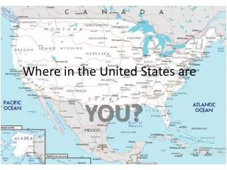
Where in the United States are . YOU?. We will practice our geography knowledge and skills . Using a simulated trip across America . Let’s Begin, Put Your Finger at…. Just west of 35°N, 81°W What state are you in? What town are you in? Go north 5° in a straight line.

E N D
We will practice our geography knowledge and skills Using a simulated trip across America.
Let’s Begin, Put Your Finger at… • Just west of 35°N, 81°W • What state are you in? • What town are you in? • Go north 5° in a straight line. • What natural barrier did you cross? • What state are you in? • What state would you have been in if it was 1845?
Using your atlas… • What is the major land use for this area? • Would this area be considered rural or urban? • If it’s May, what’s the weather like? • How far above or below sea level are you? • Get on I-81 and go to the capital of Pennsylvania. • Where are you?
From there… • Go to 40°N 96’, 75°W 16’ • What city are you in? • What state is at your east? • Now take I-95 North to the city that birthed the Sons of Liberty and the patriot cause. • Where are you? • What road should you take to go to Lake Erie? • What town do you need to go to – to see both the Erie Canal and Lake Erie?
Now…Your Turn,On the US Map • Plan a course from where you are to Topeka, Kansas. • Draw and label the freeways you’ll take. • Draw symbols that show what you’ll see on the road in each state you travel through. • Draw symbols that show experience the weather you’re experiencing (it’s May). • Label the cities and states you’ll see on the road. • Label the major meridians and lines of parallel. • Add anything else (land use, population, time zones) you think important to your trip.