Advanced Global Imaging Radiometer: Enhancing Ocean Observational Strategies
This document outlines the objectives and characteristics of an advanced global imaging radiometer designed for improved separation of in-water constituents and atmospheric correction. Key features include a 20-band sensor with minimum 1 km spatial resolution, high signal-to-noise ratio, minimal spectral interference, and comprehensive calibration programs. Applications focus on measuring geophysical parameters like phytoplankton carbon, dissolved organic carbon, and aerosol properties to enhance ocean science missions. The system aims for accurate, near-real-time processing and global coverage, addressing seasonal variability and atmospheric complexities.

Advanced Global Imaging Radiometer: Enhancing Ocean Observational Strategies
E N D
Presentation Transcript
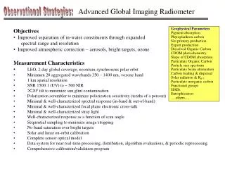
Advanced Global Imaging Radiometer Observational Strategies: Objectives • Improved separation of in-water constituents through expanded spectral range and resolution • Improved atmospheric correction – aerosols, bright targets, ozone Geophysical Parameters Pigment absorption Phytoplankton carbon Net primary production Export production Dissolved Organic Carbon CDOM photochemistry Slope of CDOM absorption Particulate Organic Carbon Particle size spectrum Particulate beam attenuation Carbon loading & dispersal Solar radiation & Kd Particulate inorganic carbon Functional groups HABs Eutrophication ….others…. Measurement Characteristics • LEO, 2-day global coverage, noon/sun-synchronous polar orbit • Minimum 20 aggregated wavebands 350 – 1400 nm, +ozone band • 1 km spatial resolution • SNR 1500:1 (UV) to ~ 500 NIR • 200 tilt to minimize sun glint contamination • Polarization scrambler to minimize polarization sensitivity (tenths of a percent) • Minimal & well-characterized spectral response (in-band & out-of-band) • Minimal & well-characterized focal plane electronic cross-talk • Minimal & well-characterized stray light • Well-characterized response as a function of scan angle • Sequential sampling to minimize image stripping • No band saturation over bright targets • Solar and lunar on-orbit calibration • Complete sensor optical model • Data system for near real-time processing, distribution, algorithm evaluations, & periodic reprocessing. • Comprehensive calibration/validation program
Advanced Global Imaging Radiometer Observational Strategies: SeaWiFS 20-band SeaWiFS Simple Expansion
Advanced Global Imaging Radiometer Observational Strategies: Hyperspectral • Multiple grating spectrometer • 5 nm resolution from 350 to 800 nm • Discrete bands from 800 to 1400 nm (20 – 50 nm bandwidth) • On-board or post-download binning • Full spectral download = 1 Tb science data per day • 300 Mbps X-band transfer to polar ground station • On-ground 20 nm binned data for standard global products • High resolution data for regional applications, events, science development Primary telescope Aft Optics
Aerosols Observational Strategies: Objective • Global characterization of absorbing aerosol properties (height, column thickness, species) in support of ocean science missions (global LEO, regional GEO, … etc) Issues • Aerosol characteristics are source dependent Urban particular problem (coastal challenge) Dust significant over vast ocean regions Non-absorbing not a problem • Seasonally and spatially varying Monitoring required • Current atmospheric correction model does not achieve required accuracy (+/-0.002 reflectance units) without correct vertical distribution (assuming correct aerosol type) • Atmospheric correction errors increase at shorter wavelengths, thus critical for effectively utilizing UV wavelengths • Aerosol loads also link to land-atmosphere-ocean feedbacks Spring Fall Measurement Characteristics (minimum) • Aerosol Heights to 0.5 km • Aerosol optical thickness range 0.05 to 1 • 10 km horizontal resolution • 10% accuracy • Extrapolation to global fields • Aerosol absorption column optical depth Equivalent Aerosol Optical Depths
Aerosols Observational Strategies: Aerosol Lidar (a) Vertical aerosol backscatter & extinction profiles (b) Layer-wise optical, microphysical, & macrophysical properties (#/surf./vol. concentrations, eff. radius, complex index of refr., SSA) (c) Aerosol particle shape and cloud liquid/ice phase GLAS (image from Jim Spinhirne) Multi-Angle or Scanning Aerosol Spectropolarimeter (a) Column-average optical, microphysical, & macrophysical aerosol properties (AOD, particle sizes & shape, SSA, size-resolved real RI…) (b) Tropospheric ozone to determine short- & long-term changes (c) Aerosol heights for ocean color correction (d) NO2, HCHO, O3 and SO2 MISR (image from David Diner)
Photons per 1 m bin per shot Depth Oligo Meso Maine 1 51 159 299 2 45 122 124 3 40 93 50 4 35 71 19 5 31 54 7 6 26 41 3 7 24 31 1 8 21 23 0 9 19 18 0 10 16 13 0 11 14 9 0 12 13 7 0 13 11 6 0 14 10 4 0 15 9 3 0 Particle Profiler Observational Strategies: Objective • Active measurement of subsurface scattering as independent measure of particle abundance Measurement Characteristics • Global survey coupled with passive ocean color measurements • ‘Sampling’ of the mixed layer • Dark- and Light-side measurements • Eyesafe lidar with surface penetrating (e.g. 532 nm) and non-penetrating wavelengths (e.g., 1064 nm) • > 15o tilt to avoid surface flash • < 20 km resolution • 1 – 2 m vertical resolution • Minimum 2 vertical depth bins • Can be same instrument as aerosol profiler CALIPSO’s CALIOP lidar Spec’s • 2-wavelength, 3-channel (532, 532, 1064) • 110 mJ Nd:Yg laser • Repetition rate = 20.25 Hz • 1 m telescope • Footprint/FOV = 100m/130rad • Mass = 300 kg • Variable vertical resolution • Aerosol height & thickness for AOD > 0.005 • Altitude = 600 km Similar to typical cirrus cloud
150 150 150 150 1064 nm Particle Profiler Observational Strategies: HG High Gain Low Gain 532 nm Lidar In-space Technology Experiment (LITE) • 3-wavelength Nd-Yg lidar • Space Shuttle in 1994 • Multi-angle (+/-300) maneuvers • Increased gain at higher angles 30 Off-Nadir Angle 15 0 Time Time
Variable Fluorescence Observational Strategies: Objective • Mapping & Monitoring Nutrient Regimes • Physiological Indices • Functional Groups Measurement Characteristics • Midnight vs Dawn differences in Variable Fluorescence (Fv/Fm) (two platforms) • Distinguish Fv/Fm values between 0.05 and 0.65 to 0.05 units • 10 – 30 km spatial resolution • Water-penetrating stimulation (e.g., 532 nm), detection at 680 nm • Spectral fluorescence detection (?) • Eyesafe LIFT (image from Zbignew Kolber) Options • Lidar • Solar Power • Clouds • Fv/Fm or simply Fo? • Suborbital or Space? • ‘Pump-n-Probe’ or ‘Painting the Surface’ (LIFT)?
Mixed Layer Depth and Illumination Observational Strategies: Objective • Time-resolved global mixed layer depths • Quantification of ocean net primary production • Characterization of photochemical reactions (CO, DMS, CO2, COS, CS2, …etc) • Surface heat budget Measurement Strategies • Assimilation of field observations into physical ocean models • Application of remotely sensed geophysical parameters (e.g., winds, heat flux, E-P, currents, SSH, SST,…etc) • Empirical retrievals from remote sensing biological or chemical stocks and transformations • Application of passive remote sensing data and optical models to calculate illumination
Mission Phasing Observational Strategies: Immediate (1 – 5 Years) Near-Term (5 - 10 Years) Long-Term (10 - 25 Years) Timeline Mission Theme Mission Themes Global Imaging Radiometer Aerosols & Particle Abund. Physiology, Functional Groups, & Fluorescence Mixed Layer Depth Technology Development Launch/Mission Backup Slides Ultraviolet Issues & Approaches Geophysical Parameters
OCEaNS Ocean Carbon, Ecosystems and Near-Shore Unexplored Territory Near Ultraviolet • Information Rich • High Energy • High Transparency South Pacific photo (Andre Morel) Santa Barbara Channel Mid-UV Near-UV Visible Near InfraRed * * Remote Sensing Reflectance = water leaving / incident
OCEaNS Ocean Carbon, Ecosystems and Near-Shore Expansion to near UV Advanced Atmospheric Correction Ozone Absorbing aerosol heights UV band near 350 nm Expanded NIR Enhanced Spectral Resolution UV Enhanced Spectral Resolution Visible Issues & Approaches • Accurate separation and characterization of CDOM & Pigment Absorption • Spectral Matching more sensitive to radiance reflectance errors than empirical ratio algorithms • ‘Black water’ assumption invalid in coastal zones for historical wavebands • Coastal waters are optically complex, with particularly problematic atmospheres • Optical distinctions are subtle b/w ecosystem components (functional groups, HABS) • Rigorous prelaunch characterization, regular lunar and solar calibration, field validation • Particulate scattering is key attribute for addressing many Carbon, Ecosystem, and Near -shore issues Fluorescence measurements • Relating particulate scattering to biomass requires description of particle size spectrum • Independent, active scattering measurements
OCEaNS Ocean Carbon, Ecosystems and Near-Shore Spectral beam attenuation coefficient retrieved from ocean color inversion Collin S. Roesler, Emmanuel Boss (2003) Loss Rate (day-1) Growth Rate (day-1) W.Balch, Bigelow Laboratory 0 0.5 1.0 1.5 2.0 Growth Rate (div d-1) Johannessen et al. 2003 Alvain et al. 2005 Passive Geophysical Parameters Algorthm Product Geophysical Parameter • Pigment absorption • Phytoplankton carbon • Net primary production • Export production • Dissolved Organic Carbon • CDOM photochemistry • Slope of CDOM absorption • Particulate Organic Carbon • Particle size spectrum (pss) • Particulate beam attenuation • Carbon loading & dispersal • Solar radiation & Kd • Particulate inorganic carbon • Functional groups • HABs • Eutrophication GLAS profile data aph(spectral matching) bbp(spectral matching, lidar) Phyto C, C:Chl, PAR, MLD, Kd, part. size spec., fluor. (Phyto C, NPP, MLD)t, Ecosystem Model CDOM (spectral matching), empirical algorithms CDOMt, PAR, MLD, Kd, Degredation model CDOM (enhanced spectral UV/VIS resolution) bbp, pss (spectral matching, lidar) Spectral matching with enhanced VIS resolution High VIS spectral resolution, Lidar Near-shore particulate and dissolved carbont UV/VIS radiances, modeling bbp(spectral matching), empirical algorithm High VIS (UV?) spectral resolution High VIS (UV?) spectral resolution Near-shore Phyto C & NPP, fluorescence