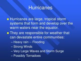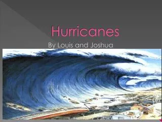
Hurricanes
Hurricanes. Chapter 11. Tropical Weather. Where are the tropics?? The region between 23.5º N and 23.5º S latitude Between the Tropics of Capricorn/Cancer The region of the earth where the noon sun is always directly overhead somewhere

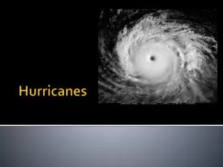
Hurricanes
E N D
Presentation Transcript
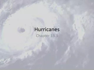
Hurricanes Chapter 11
Tropical Weather • Where are the tropics?? • The region between 23.5º N and 23.5º S latitude • Between the Tropics of Capricorn/Cancer • The region of the earth where the noon sun is always directly overhead somewhere • Because the sun is always relatively high in the sky, what kind of seasonal temperature changes would you expect? • Not much • Not much daily change either
Tropical Weather • Seasons are instead marked by changes in precipitation • Wind and pressure are also different than in the mid-latitudes • Winds are usually easterly (not westerly) • Pressure variations at the surface are usually small • Small pressure changes from place to place make isobars almost worthless for finding weather features
Tropical Weather • In the tropics we look at “streamlines” instead of isobars • Lines that show wind direction • Also show where wind converges or diverges • Kinks in the streamlines indicate weak areas of lower pressure called “tropical waves” • Under right conditions...
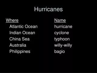
Hurricanes • Defn. - an intense storm of tropical origin, with sustained winds exceeding 74mph • Term “hurricane” is reserved for storms is the N. Atlantic and Eastern N Pacific • Elsewhere - “cyclones”, “typhoons”, etc. • “Tropical Cyclone” is a generic term everyone agrees upon
Hurricanes • Size varies but on avg: • ~ 300 miles wide • Eye varies also • smaller diameter usually means more intense • Hurricanes are intense areas of low pressure • Strong ones have much lower pressure than mid-latitude lows • Wind direction at surface? • Counterclockwise and inward Eye Eye Wall
Vertical Structure • Overcast sky at first (cirrostratus) • Little pressure change • Air is moving toward the center from the W or NW Hurricane Hunter
Vertical Structure • Start to see showers and thunderstorms as we approach the center • Wind speed picks up - pressure starts to drop off more quickly • Huge seas - 30-50 ft!
Vertical Structure • Intense wind and rain as we enter the eye wall • Strongest winds and heaviest rain in the entire storm! • Then we pop out of the bad weather and into the eye • Lowest pressure, light winds, higher temperature, and maybe even clear sky above
Vertical Structure • Large scale flow is: • 1) inward at the surface, 2) then upward in the eye wall, 3) outward aloft, and 4) downward at the edges H L
Vertical Structure • Notice the high pressure aloft and low pressure at the surface • Ideal setup - strong high pressure aloft allows for maximum amount of air to move out of the vertical column • lowest pressure possible at surface H L
Hurricanes • So winds at surface are counterclockwise around the low • Winds aloft are clockwise around the upper level high • Satellite loops often show this….looks as if it’s spinning the wrong way • Upper level clouds are the ones seen
Vertical Structure • Smaller scale flow is: • 1) Upward in the “spiral bands” of thunderstorms, 2) downward in between, and 3) sinking in the eye (clear skies) • Depth of the flow increases toward the center
Formation • Hurricanes generally form in regions with • 1) Warm tropical waters (~80ºF) • 2) Light wind • 3) High humidity through a deep vertical layer ….. tropics • In the N. Atlantic and Eastern N. Pacific, these conditions prevail in the summer and early fall • Hurricane season is June - November • One other thing we need • 4) Convergence of air at the surface
Formation • Convergence • Preferably at a region of weak low pressure • Starts counterclockwise rotation • Recall from earlier in the semester: • Wind is a balance of forces • Coriolis, PGF, etc. • From what you know, can a hurricane form at the equator? That’s about as tropical as you can get right? • NO! Coriolis force = zero at the equator • Rotational wind is not possible
Formation • Convergence • Usually have to be poleward of 5º • So most hurricanes form between 5º - 20º N latitude in the N. Hemisphere • Where does this convergence take place? • Old frontal boundaries • Where the northeast and southeast trade winds meet (ITCZ - Inter Tropical Convergence Zone)
Formation • Even with all of the ingredients in place, tropical development may not happen • Inversions may cap the rising air • Strong winds and shear aloft can destroy a developing tropical system • But, if all goes well (or badly if you’d like), a tropical system will develop through 4 stages
Formation • 1) Tropical wave • Just an area of weak low pressure and convergence of surface winds
Formation • 2) Tropical depression • Closed isobars on a weather map • Winds 20-34 knots
Formation • 3) Tropical storm • Several closed isobars • Winds 34-64 knots • System gets a name at this point
Formation • 4) Hurricane • Tropical system with winds in excess of 64 knots (74 mph)
Hurricane Categories • Hurricane strength is rated by wind speed on the Saffir-Simpson Scale • Categories range from 1 - 5 with 1 being the weakest and 5 being the strongest • Table 11.2 on page 307 • Category 3 or higher (winds >111 mph) indicates a “major hurricane” • Less than 1 major hurricane per year hits the U.S. coast • But when they do, damage is severe
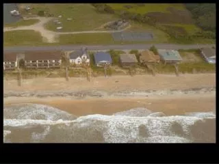
Hurricane Damage • Damage from hurricanes is due mainly to: • Winds • Storm surge and flooding • Combination of high waves, heavy rain, etc. • Causes most damage and deaths • Particularly devastating when hurricane landfall coincides with high tide • So, most of the damage is at or near the coast • Does is matter which side of the storm you’re on?
Hurricane Damage • Yes - east side usually has strongest winds • Depends on direction of movement also
Hurricane Damage • This storm has 75 knots winds and is moving north at 25 knots • Looking at wind direction: • East side - winds moving northward at 75 knots and + speed to north at 25 knots = 100 knot winds • West side -wind moving south at 75 knots - speed to north at 25 knots = 50 knot winds
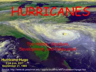
Hugo • So when Hugo hit S. Carolina, the heaviest damage was on the north side of the eye wall
Hugo • Category 4 when it hit • 138 mph winds • Pressure 934 mb • Surge 8-20 feet
Hugo • Category 4 when it hit • 138 mph winds • Pressure 934 mb • Surge 8-20 feet
Andrew • Costliest natural disaster in U.S. history • $30 billion dollars • 53 deaths (41 in Florida) • 160,000 left homeless • 200,000 homes/businesses damaged or destroyed
Satellites • Huge help in terms of advanced warning time • Try to imagine NOT having a vantage point from space… • Ex. Hugo (49 deaths) and Andrew (53) • Pre satellites: • 1900 - Galveston, TX - more than 6,000 deaths • 1919 - Keys - more than 600 • 1928 - Near Lake Okeechobee - 1,836 • 1935 - Keys - 408
Landfalling Storms • 162 storms hit the U.S. coast from 1900-1999 • Only 2 Cat 5s