Download
1 / 32
320 likes | 452 Vues
Explore seismic shaking scenarios using the ModelAssembler Community Modeling Environment (MA-CME) for Nevada's urban areas. Generate multi-gigabyte E3D input grids, define earthquake sources, and analyze basin-thickness inputs. Detailed study of fault systems like Frenchman Mountain Fault, Genoa Fault, and Northern Death Valley Fault Zone. Understand directivity effects and PGV amplifications based on rupture scenarios.

E N D
Seismic Shaking inNevada’s Urban Areas:Computing Simple Scenarios John Louie, 2/7/07 • Fall 2006 Geol 455 students: • Liz Lenox • Rei Arai • Amr Wakwak
ModelAssembler • A code to stitch together existing regional geophysical and geological data sets. • Generates multi-gigabyte E3D input grids.
The ModelAssembler Community Modeling Environment (MA-CME) • Graphical user interface for setting up MA/E3D “.in” files. • Provides tutorial help to successful setup. • Data sets, stations, grids all defined with geographic lat/lon (have to decide on WGS84, NAD27, etc.). • Easy configuration of problems at all scales and computational difficulties- 10 Mb to 100 Gb. • After setup, “portal pack” is downloaded to cluster and run. • Open source: www.seismo.unr.edu/ma • Limits: flat earth; no topography; 1-D variations within basins & bedrock; source and stations in same grid.
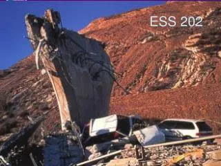
Frenchman Mountain Fault • 4x4-km N-striking M5.0 scenario • West-dipping oblique-normal • Late Quaternary (<130 ka) • Less than 0.2 mm/yr • By Amr Wakwak (Fulbright PLUS Program)
Frenchman Mountain Fault Scott et al. (2006) Vs30 model from 1100+ wells, 79 Vs profiles. Thanks to W. Taylor of UNLV & G. Wagoner of LLNL
Frenchman Mountain Fault Langenheim et al. model from gravity, refraction, a few deep wells.
Frenchman Mountain Fault Animation combines inputs and outputs. E3D computation at 0.3 Hz on a 144x137 grid with dh=308 m. Grid resolution is a good match to cell phone displays.
Frenchman Mountain Fault PGV >5 cm/s above west-dipping fault at 0.3 Hz. Sub-basins contain the greatest shaking.
Frenchman Mountain Fault Schools closest to the fault experience greatest PGV but shortest durations.
Genoa Fault – Mount Rose Fault Systems Virginia Lake • 80 km long • East-dipping oblique-normal • Latest Quaternary (<15 ka) • 1.0-5.0 mm/yr • Northward rupture scenario from W. Fork Carson Riv. to Virginia Lake • By Rei Arai W. Fork Carson Riv.
Genoa Fault – Mount Rose Fault Systems Scott et al. (2004) Vs30 transect. Pancha measurements at ANSS stations. “Quadrant” interpolation between scattered measurements, respecting geologic map. Vs30=500 m/s assumed on sediment, 760 m/s (white and cyan) on rock.
Genoa Fault – Mount Rose Fault Systems Three datasets, not well stitched together: • Geologic map with basin depths assumed from bedrock proximity, in California. • Jachens et al. USGS basin gravity inversions for Basin & Range; sedimentary plus Tertiary volcanic basins. • Abbott & Louie (2000) Reno basin gravity study.
Genoa Fault – Mount Rose Fault Systems Dataset mismatches plain in model renderings. Extreme directivity effect. E3D computation at 0.3 Hz on a 120x200 grid with dh=500 m. Olsen and Day Q model included.
Genoa Fault – Mount Rose Fault Systems West Reno basin, above end of rupture, has 5x the PGV of any other basin near fault. Highest shaking not correlated with basin depth- Tahoe artificially deep in this model. Dataset boundaries not interfering with these conclusions.
Genoa Fault – Mount Rose Fault Systems West Reno stations have high PGV and long durations.
Northern Death Valley Fault Zone Ubehebe Crater • 80 km long • Dextral strike-slip • 1.0- 5.0 mm/yr • Latest Quaternary (<15 ka) • Two M7.5 scenarios: • Rupture from SE, epicenter at Furnace Crk. • Rupture from NW, epicenter at Ubehebe Ctr. • By Liz Lenox Furnace Creek
Northern Death Valley Fault Zone Jachens USGS geologic map sets default soil and rock Vs30s. Scott et al. (2006) Vs30 model from 1100+ wells, 79 Vs profiles inserted for LVV.
Northern Death Valley Fault Zone Jachens Basin & Range gravity inversions for sedimentary & volcanic basins. Timber Mtn. caldera & rifts up to 8 km deep. Langenheim et al. model from gravity, refraction, a few deep wells inserted for LVV.
Northern Death Valley Fault Zone Animation combines inputs and outputs. E3D computation at 0.3 Hz on a 281x251 grid with dh=1 km. Infinite Q. The two rupture scenarios have very different effects.
Northern Death Valley Fault Zone For rupture away from city, PGV <<1 cm/s in LVV. Clear directivity in this long-period simulation.
Northern Death Valley Fault Zone For rupture toward city, PGV >1 cm/s in LVV. Clear directivity in this long-period simulation. Basins between DV and LVV are spreading the directivity effect to wider angles from the fault strike.
Northern Death Valley Fault Zone Ratio of PGV from rupture toward LVV, over away. Largest amplifications due to directivity are in bedrock. Some margins of LVV also show 1500% amplifications.
Northern Death Valley Fault Zone Compare PGV of 2679 areas, each 1-km2, in LVV against Vs30 and Z2.0.
Vs30 affecting 1.5-km waves! Northern Death Valley Fault Zone
Conclusions • Students can use MA-CME to set problems up, but plotting and visualizing are still lots of work. • Scenario Results: • M5.0 Frenchman Mtn.– high PGV accompanied by short duration. • M7.5 Genoa–Mt. Rose– Reno basin gets 5 times the PGV of any other. • M7.5 No. Death Valley– rupture toward city produces up to 15 times the PGV as rupture away. • At long periods, 0.3 Hz, E3D is producing huge uncertainties in PGV.