RPS Modeling Results
1. RPS Modeling Results. Presentation to RPS Policy Committee Brian Gregor Transportation Planning Analysis Unit June 6, 2006. 2. Presentation Outline. Summary of modeling approach, objectives and status Presentation of modeling results Conclusions Next steps. 3.

RPS Modeling Results
E N D
Presentation Transcript
1 RPS Modeling Results Presentation to RPS Policy Committee Brian Gregor Transportation Planning Analysis Unit June 6, 2006
2 Presentation Outline • Summary of modeling approach, objectives and status • Presentation of modeling results • Conclusions • Next steps
3 Summary of Modeling Approach, Objectives and Status
4 Strategic risk-based approach to land use and transportation modeling • Recognizes uncertainties about how land will develop in the future • Helps identify the priorities of transportation problems • Helps identify opportunities for using land use to avoid or lessen transportation problems
5 Legend Rural Urban Growth Area Poss. Urban Reserve Highway Poss. Highway • Standard land use forecast approach is based on aspirations and consensus. • Doesn’t necessarily reflect market forces • Doesn’t respond to transportation projects • Land use models reflect market forces and transportation improvements, but most don’t address possibility of alternative outcomes. Highway location affects land development patterns. Potential urban reserve areas for inclusion into urban growth boundaries. They affect future transportation demand.
6 A B • Land use model for RPS study is sensitive to aspirations, but also reflects market forces and transportation. • It also recognizes uncertainties in where development will occur. A Highway improvement needed above this threshold B Traffic Volume
7 Modeling Objectives • Evaluate alternative growth scenarios and transportation improvements: • How is the transportation system affected? • What we need to pay attention to? • What transportation improvements are needed to serve future growth?
8 Modeling Status • Completed land use modeling. • Assumed population doubles. • Assumed all proposed growth areas available for development. • Completed transportation modeling on land use scenarios. • Assumed only projects in fiscally constrained RTP are built.
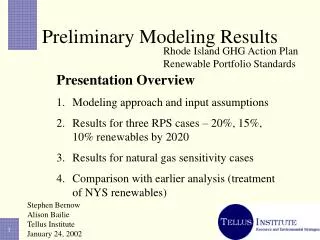
9 Modeling Results
10 Orientation • Model reflects UGB comprehensive plans and proposed land uses in potential growth areas. • Central Point and Jackson County alternatives for Tolo area were both modeled. • Model works at the transportation analysis zone (TAZ) level. • Results are being presented at a larger scale district level.
11 Rogue Valley MPO Model Area Showing RPS Growth Study Areas and Reporting Districts
12 Summary of Housing Modeling Results • Surplus land supply results in volatility of housing patterns. • Less variation seen in Ashland and West Medford areas because of limited land supplies. • Most population variation in Eagle Point, Central Point, North Medford and East Medford. • Housing volatility related to volatility in travel patterns (see below).
13 Summary of Housing Modeling Results • Several smaller places don’t vary much in total amount, but vary considerably in percentage terms. • White City, Eagle Point, Jacksonville, and Tolo • Tolo varies widely because of competing growth proposals. • Results in substantial volatility in travel and congestion in these smaller areas.
14 Summary of Housing Modeling Results • North Medford and Central Point show much variability in absolute and percentage terms. • Volatility of development in these areas has significant consequences for travel and congestion.
15 Summary of Employment Modeling Results • Employment variability is similar to housing. • East Medford, Central Point, White City, West Medford and North Medford are highly variable. • Phoenix, Eagle Point, Jacksonville and Tolo are small but vary substantially in percentage terms. • Ashland varies little. • These patterns also show up in the transportation results.
16 Region-wide Transportation Results • VMT, travel time, and freeway travel vary very little among scenarios • VMT: less than 2% • Travel time: less than 3% • Freeway VMT %: less than 2% • Total delay, employment accessibility and transit accessibility vary significantly • Delay: 35% • Jobs accessible within 10 minute drive: 9% • Jobs served by public transit: 7%
17 Traffic Monitor Sites NOTE: Although these locations are shown as points, they represent all sections of roads that have the same number of lanes and similar amounts of traffic.
18 Congestion at Traffic Monitor Sites NOTE: Although these locations are shown as points, other portions of roadways with the similar traffic and the same number of lanes can be expected to have similar congestion. These results do not show congestion at interchanges or intersections.
19 Congestion at Traffic Monitor Sites NOTE: Although these locations are shown as points, other portions of roadways with the similar traffic and the same number of lanes can be expected to have similar congestion. These results do not show congestion at interchanges or intersections.
20 Variability and Severity of Congestion at Traffic Monitor Sites NOTE: Although these locations are shown as points, other portions of roadways with the similar traffic and the same number of lanes can be expected to have similar congestion. These results do not show congestion at interchanges or intersections.
21 Conclusions
22 Land use arrangements don’t significantly affect overall travel, but do affect congestion delay and accessibility • VMT, travel time and freeway travel are similar for all land use patterns • However, congestion delay varies substantially and accessibility varies to a lesser extent
23 Several corridors will experience high levels of congestion • Crater Lake Highway and Table Rock Road • Central portion of I-5 • Route 99 and Phoenix Road • Route 238 to Jacksonville (Congestion at interchanges will be evaluated later)
24 High levels of congestion will split the region • White City and Eagle Point will be separated from North Medford and Central Point. • Phoenix, Talent and Ashland will be separated from Medford and Jacksonville
25 Congestion varies noticeably with land use • Clearly related to land use patterns. • Occurs at all levels of congestion. • Affects whether or not the facility is congested. • Large variation occurs in several congested and severely congested locations.
26 Next Steps
27 Next Steps • First round of modeling is complete. Need to plan second and third rounds. • Model can be used to test alternative growth area proposals. • Amount of land, geographic distribution, and development types • Model can also be used to test transportation system changes.
28 End