Download
1 / 20
200 likes | 422 Vues
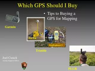
Which GPS Should I Buy. Tips to Buying a GPS for Mapping . Garmin. Pro XR. GeoExplorer 3. Trimble. Joel Cusick Alaska Support Office. PLGR. Outline. What a GPS Mapping Receiver should do Overview of Main GPS Receiver Types PROS/CONS of Receiver Types

E N D
Which GPS Should I Buy • Tips to Buying a GPS for Mapping Garmin Pro XR GeoExplorer 3 Trimble Joel CusickAlaska Support Office PLGR
Outline • What a GPS Mapping Receiver should do • Overview of Main GPS Receiver Types • PROS/CONS of Receiver Types • The Best Tool for the Job
Assumptions • You supervise people or work in one/many parks in Alaska • You want to record your field locations or map existing infrastructure, trails • Use to navigate to/from • Archive the locations in a later in a GIS • You have access to the wonderful AKSO Intranet and the X:drive
What a GPS Mapping Receiver should do • Hardware • Software • Support
What a GPS Mapping Receiver should do • Hardware • Accuracy (How close to Truth) • Meet National Mapping Accuracy Standards: • 1:63,360 (32meters) • 1:24,000 (12 meters) • 1:5,000 (4 meters) • Precise (How reliable) • Rugged • Able to Average a Point • External Antenna options • Good on Batteries No Problem!
What a GPS Mapping Receiver should do • Software • Export in GIS Friendly Formats (shapes, coverages) • Capable of Controlling Attributes in the Field • Data Dictionary (Name, Trail Width, Comments) • Capable of Datum Transform • Mission Planning • Sky Plots • Planning the day • Run on standard PC / equipment
What a GPS Mapping Receiver should do • Support (AKSO) • Manufactured by Trimble, Garmin or Rockwell • GIS Products that utilize ESRI - NPS Standard • ArcView • ArcInfo • Ensure your data has long shelf life
Overview of Main Types • Recreational Grade GPS - Garmin • Mapping Grade GPS - Trimble • Y-Code Receivers - Rockwell PLGR+96
Recreational Grade GPS - Garmin • Features Include: • Wide Use -Alaska National Parks/AKSO = 60 • Accuracy: • Autonomous < 15meters 95% typical • DGPS ready 3-5 meters 95% typical • User Friendly • Many models • Garmin GPSIII+, GPSMap76, eTrex • Moving Base Maps (1:100,000 scale) Garmin
Mapping Grade GPS - Trimble • Features Include: • Wide Use -Nationally • AKSO (dozen) • Accuracy: • Autonomous < 15meters 95% typical • Post-Process DGPS • 3-5 meters 95% typical (Geo3) • 1 meter 95% typical (ProXR) • Pathfinder Office Software • Data Dictionary, Mission Planning Trimble
Y-Code Receivers - PLGR+96 • Features Include: • Rugged • Good under Canopy • 999 Waypoint Storage • EHE displayed • Datum Switch seen in ASCII Out PLGR
GPS for GIS - Pros and Cons • Garmin III+ • Pros • Cheap and consistent 15 meters positions - good under canopy • Good “Point tool” • Fun and easy to use • Integration into ArcView - relatively straightforward • Battery usage is great • Cons • Cheap • Position accuracy not so trustworthy • Not designed for GIS Mapping - relies on 3rd party software • No Data Dictionary capability • Decent storage of tracks/waypoints (6-10 hours)
GPS for GIS - Pros and Cons • Trimble GeoExplorer 3 • Pros • 1-5 meter mapping tool • Point/Line/Poly • Rugged • Collect for 16 hours • Software is excellent • Cons • $4000 • Firmware will be changing? • Under Canopy issues - must use antenna • No Data Dictionary • Very small storage of tracks/waypoints(999) • Need to post-process after the field (internet connection)
GPS for GIS - Pros and Cons • Trimble Pro XR • Pros • Top-of-the-line GIS Mapping Tool • Real-time DGPS • Point/Line/Poly • Good under Canopy • Rugged • Software is excellent • Cons • $10,000 • Big/Bulky • Firmware will be changing • Training involved
GPS for GIS - Pros and Cons • PLGR • Pros • Consistent 15 meters positions • Familiarity (bugs worked out) • Good “Point tool” • Rugged. Records error • Integration into ArcView - relatively straightforward • Cons • Older technology • Heavy • Terrible on batteries • Club Fed only • No Data Dictionary capability • Very small storage of tracks/waypoints(999)
Right Tool for the Right Job • Sorry… It’s a Multi - Tool Environment • Garmin • Trimble • PLGR • Need to learn enough about each system to know when to use the tool • Mapping a trash can lid? - ProXR • Mapping a ATV trail - Garmin, Geo3 or ProXR • Mapping sheep from the air? - Garmin\PLGR • Mapping complex attributes? - Geo3 or ProXR • In Dense Canopy - PLGR / ProXR
Ideal GPS Toolkits • Garmin for navigation, point collection • Use DGPS system only if working along Gulf of Alaska, Southeast, out on the water • PLGR for dense people / dense canopy • For Serious GIS • Trimble Geo3 for open country mapping • Trimble Pro XR for everything
What is Best? • Ask Yourself • 1) What are your accuracy needs? • A) resolution of the other data types • B) anticipated data for the future • 2) Project Needs • A) What are your GIS skills • B) Is it just you dealing with the data • 3) What part of Alaska are you working in? • 4) How much money do you have?
Winzip Executibles • Designed for distribution • Embedded help sheets GPS Toolkits
GPS Training • Yearly training Events • Orienteering • Awareness Briefings • Training • WRST (May 14-17) • Accupoint (This summer)