
Indian Removal Map Activity
E N D
Presentation Transcript
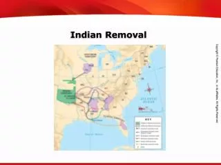
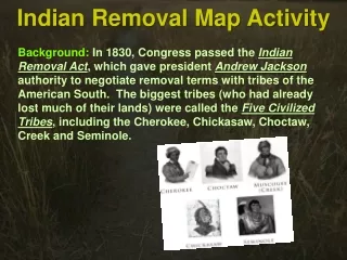
Indian Removal Map Activity Background: In 1830, Congress passed the Indian Removal Act, which gave president Andrew Jackson authority to negotiate removal terms with tribes of the American South. The biggest tribes (who had already lost much of their lands) were called the Five Civilized Tribes, including the Cherokee, Chickasaw, Choctaw, Creek and Seminole.
Indian Removal Map Activity Background: The act was strongly supported by non-natives, many of whom wanted to settle on native lands. The idea that whites should populate the continent is called manifest destiny. Some Americans opposed the law, including many Christian missionaries who recognized the act as unfair and unjust.
Indian Removal Map Activity Background: Much of the populations of these tribes were forced to move to Indian Territory in what became Oklahoma. Many natives died along the way in what became known as the Trail of Tears.
Indian Removal Map Activity Follow along with this blank map to trace the movement of the Five Civilized Tribes after the 1830 Indian Removal Act.
Indian Removal Map Activity Choctaw Chickasaw Cherokee Oklahoma Indian Territory Creek Seminole Before you begin, select SEVEN (7) different colored pencils, crayons, highlighters, or markers. It does not matter which colors you use for each tribe or territory, as long as you know which is which…
Indian Removal Map Activity Step 1: Outline Oklahoma Territory (which later became the state of Oklahoma) Oklahoma
Indian Removal Map Activity Step 2: Using a different color, outline Indian Territory within Oklahoma Oklahoma Indian Territory
Indian Removal Map Activity Step 3: Using a new color, label and shade the Choctaw territory (c. 1830) Oklahoma Indian Territory Choctaw
Indian Removal Map Activity Step 4: Trace the journey that brought the Choctaw to the new Indian Territory Oklahoma Indian Territory Choctaw
Indian Removal Map Activity Step 5: Label and shade the newChoctaw territory in Oklahoma (c. 1831) Oklahoma Choctaw Indian Territory Choctaw
Indian Removal Map Activity Step 6: Using a new color, label and shade the Seminole territory (c. 1830) Oklahoma Choctaw Indian Territory Choctaw Seminole
Indian Removal Map Activity Step 7: Trace the journey that brought the Seminole to the new Indian Territory Oklahoma Choctaw Indian Territory Choctaw Seminole
Indian Removal Map Activity Step 8: Label and shade the newSeminole territory in Oklahoma (c. 1832) Oklahoma Seminole Choctaw Indian Territory Choctaw Seminole
Indian Removal Map Activity Step 9: Using a new color, label and shade the Creek territory (c. 1830) Oklahoma Seminole Choctaw Creek Indian Territory Choctaw Seminole
Indian Removal Map Activity Step 10: Trace the journey that brought the Creek to the new Indian Territory Oklahoma Seminole Choctaw Creek Indian Territory Choctaw Seminole
Indian Removal Map Activity Step 11: Label and shade the newCreek territory in Oklahoma (c. 1834) Oklahoma Creek & Seminole Seminole Choctaw Creek Indian Territory Choctaw Seminole
Indian Removal Map Activity Step 12: Using a new color, label and shade the Chickasaw territory (c. 1830) Oklahoma Creek & Seminole Seminole Choctaw Chickasaw Creek Indian Territory Choctaw Seminole
Indian Removal Map Activity Step 13: Trace the journey that brought the Chickasaw to the new Indian Territory Oklahoma Creek & Seminole Seminole Choctaw Chickasaw Creek Indian Territory Choctaw Seminole
Indian Removal Map Activity Step 14: Label and shade the newChickasaw territory in Oklahoma (c. 1837) Oklahoma Creek & Seminole Seminole Choctaw Chickasaw Chickasaw Creek Indian Territory Choctaw Seminole
Indian Removal Map Activity Step 15: Using a new color, label and shade the Cherokee territory (c. 1830) Oklahoma Creek & Seminole Seminole Cherokee Choctaw Chickasaw Chickasaw Creek Indian Territory Choctaw Seminole
Indian Removal Map Activity Step 16: Trace the journey that brought the Cherokee to the new Indian Territory Oklahoma Creek & Seminole Seminole Cherokee Choctaw Chickasaw Chickasaw Creek Indian Territory Choctaw Seminole
Indian Removal Map Activity Step 17: Label and shade the newCherokee territory in Oklahoma (c. 1838) Oklahoma Cherokee Creek & Seminole Seminole Cherokee Choctaw Chickasaw Chickasaw Creek Indian Territory Choctaw Seminole
Indian Removal Map Activity The finished product should look something like this… Oklahoma Cherokee Creek & Seminole Cherokee Choctaw Chickasaw Chickasaw Creek Indian Territory Choctaw Seminole
Indian Removal Map Activity On the back of your map, write two sentences describing what happened. These two sentences should include at least four of the key terms listed below. Oklahoma Cherokee Creek & Seminole Cherokee Choctaw Chickasaw Chickasaw Creek Indian Territory Choctaw Key Terms: Andrew Jackson Indian Removal Act Manifest Destiny Five Civilized Tribes Oklahoma Indian Territory Trail of Tears Seminole