NOAA's Climate Reference Network: Advanced Automated Monitoring for Extreme Climates in Tiksi, Russia
350 likes | 473 Vues
The NOAA's Climate Reference Network (CRN) is designed to provide long-term climate monitoring in extreme environments, such as Tiksi, Russia. This automated climate observatory, established during a planning meeting in March 2007, focuses on adherence to WMO standards and the implementation of durable site infrastructures for 50-100 years. Key features include layered communication systems, laboratory-grade instrumentation, and an emphasis on meticulous metadata and data quality control. The Tiksi station aims to ensure high data completeness and reliability while monitoring critical climate variables.

NOAA's Climate Reference Network: Advanced Automated Monitoring for Extreme Climates in Tiksi, Russia
E N D
Presentation Transcript
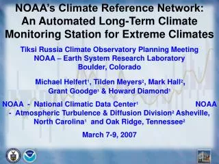
NOAA’s Climate Reference Network: An Automated Long-Term Climate Monitoring Station for Extreme Climates Tiksi Russia Climate Observatory Planning Meeting NOAA – Earth System Research Laboratory Boulder, Colorado Michael Helfert1, Tilden Meyers2, Mark Hall2, Grant Goodge1 & Howard Diamond1 NOAA - National Climatic Data Center1NOAA - Atmospheric Turbulence & Diffusion Division2Asheville, North Carolina1 and Oak Ridge, Tennessee2 March 7-9, 2007
What’s So Special About Climate Reference Stations? • Location, location, location!! Pristine areas. • Adhere to WMO Climate Monitoring Standards. • Station Hosts provide site for 50-100 years in undeveloped or natural state. ----------------------------------------------------------------------------------------------------------------------------- • Layered comms enhance data completeness. • Laboratory-grade, redundant instrumentation. • Emphasis on metadata & data ingest (98%). • Daily monitoring, QA/QC, traceable standards, systematic maintenance/ calibration pgms
Considering A Proper CRN Precision Sensor Suite for Tiksi** • Conservative Tiksi Option: Mount the Redundant Climate Reference Network Precision Primary Sensors for P & T# on 10m or 50m towers. • Air Temperature (power-aspirated; radiation-shielded); • Precipitation Accumulation (All-Weather/Temperature). • #1.5 mtrs above deepest snowpack • OtherPossible Measurements at 1.5 meters • Wind Speed (at sensor throat/inlet) - Wv/Wd sensor? • Global Solar Radiation – dubious merit • Ground Surface (Skin) Temperature – dubious merit • -----------------------------------Not Advised----------------------------------- • Relative Humidity – Very low end of sensor range. • Barometric Pressure – is better instrument available? • Soil moisture/temperature – permafrost/muskeg • **WMO Climate Observing Standards National Climatic Data Center
Primary Instrumentation Only Three separately housed, power-aspirated platinum- resistance thermometers Four precipitation gauges inside a double windshield, with a single alter as 3rd windfence T2 T1 T3
Fairbanks, Alaska CRN Station 8-meter diameter SDFIR surrounds the four precipitation gauges Power Feed Central Tower, Instruments & Datalogger SDFIR elevated above mean January snow depth.
An All-Sensor Climate Reference Network Station Cornell University, New York State Satellite comms (pre-cover) Multi-check precipitation gauge with backup gauge inside a large wind fence Relative Humidity Power Control Anemometer Ground Temperature Solar Radiation (Pyranometer) Three Lab-Grade Thermometers in Individual Ventilated Radiation Housings Wetness Sensor Soil Moisture & Soil Temperature Datalogger
Redundant CommunicationsCRN has multiple data communication levelsto assure 98% archival data ingest for POR A daily status report verifies the condition and availability of all communications networks and station data reports. 1-3. Three separate satellite receiving stations and backups for three GOES satellites. 4-6. Transmissions include previous two hours obs. 7. Individual Station Dataloggers (34-month storage). (8). Local readout desired/required (?). ----------------------------------------------------------------- • There are 96 CRN sites operating, 50+ more planned. • Two stations report via ground communications (test sites). • The other 94 report via the GOES DCS satellite system. • Network data ingest for POR (2000-2007) is 99.7% March 5, 2007
Antenna icing initially led to low data collection until a slippery fiberglass cover was backfitted in 2005. Data ingest increased from Barrow Alaska from 72% to 98+% completeness following antenna cover installation. Fiberglass yagi antenna cover at Barrow, AK
USCRN Data Ingest, 2000-2007 2000 2 stations 89+% 2001 16 stations 92+% 2002 31 stations 97+% 2003 50 stations 98+%** 2004 64 stations 99.1% 2005 78 stations 99.8% 2007 (March) 88 stations 99.7% **98% data completeness is the Minimum Data Ingest Floor
Typical U.S. CRN Precipitation Gauge in light-to-medium snowfall area (Quinnault WA). Gauge throat elevation is 1.5 meters to conform to WMO Measurement Standards.
Barrow Alaska – Lesson Learned: “Normals” are changing – therefore build the wind fence above the expected (new) record snowfall ... (March 2004) • Barrow Tower Antenna Cover, 03 2005.JPG
Barrow SDFIR Newly Elevated SDFIR at Barrow, Alaska CRN Station
CRN Fairbanks, AK SDFIR elevated above mean January snow depth.
Geonor Triple-Transducer Precipitation Gauge Mass/depth of precipitation is determined by frequency of wire variation. Picture is of single transducer/wire Geonor gauge. CRN site gauges have three transducers/wires around gauge. transducer/wire
Aspirated shields with solar radiation sensor and satellite antenna, Murphy, Idaho
Survival of Barrow, Alaska station after polar bear hug(s). No sensor damage and no sensor drifts out of calibration followed. Bent & twisted radiation shield – instrument OK. T1 T3 T2 Crushed radiation hat – instrument continued functioning nominally
NOAA Engineer Summer Luncheon: CRN Station Maintenance, Barrow AK
Polar beer laying in the grass waiting for a CRN engineer to lunch with: Barrow, Alaska
Primary Outer Rainbands 1 and 2 Newton Mississippi CRN Station Hurricane Eye Hurricane Katrina 127 mph at landfall 1300 Hours CST August 29, 2005
Local Time (hrs) Peak Wind at 1.5 m = 13 m/s North Storm morphology South
Phenomena That Have Fooled Us:St. Mary (Glacier National Park), Montana, Ground Effect Blizzard:Climate Reference Network (CRN) & Remote Automated Weather Station (RAWS) Measurements 3 clear days with constant snowfall: Nov 29- Dec 1, 2006
False Snow Event Winds-Glacier National Park, Montana • Winds were measured at St. Mary CRN and the nearby (200m) Natl Park Service RAWS, 29 Nov-1 Dec 2006 • Instrument elevation differences: • CRN anemometer 1.5 mtrs; • RAWS anemometer 10 mtrs. • Winds at both locations in close agreement during event – variance <5%. Max winds 29 mph St. Mary CRN (1.5 m); 31 mph St. Mary RAWS (10M). • Webcam showed laminar-flow blowing snow with thickness of 15-20 mtrs persisted for 3 days. False precip total estimated at 10 mm.
Web cam view SW 0920 MST Jan 31, 2007 Temp 19 F (-8 C) Reference Stake
Web cam view SW at 12:17 MST Nov. 29, 2006 Temp. 12 F (-11C) Wind Gust SSW 31 mph Reference Stake
CRN Station Lessons – Alaska; Rocky Mountains; Montana; Maine • Sturdiest possible equipment to withstand wildlife curiosity & extreme environments. • Use multiple sensors in case one fails. • Plan for deep snow, & raise station vertically. • Record data locally for comms outages. • Build stations where there is reliable power. • Daily QA/QC (HON) monitoring & analysis. • Goal is highest confidence, irrefutable data. • Adhere to WMO, NAS, NOAA Climate Principles. • Plan to suceed; don’t be arrogant; learn; evolve.
Hi-lat/Hi-elevation monitoring difficulties • Site stability, access, and security • Power and maintenance • Personnel safety is primary – not data. ------------------------------------------------------------ • How extreme is the climate environment? • Are climate normals & extremes shifting? • What phenomena are we unprepared for? • What climate phenomena will fool us? • Rigidity of our mental constructs?
Where Can the CRN Data and Information Be Found??? Internet (Web) Access or, go directly to the “Index”:www.ncdc.noaa.gov/oa/climate/uscrn/index.html USCRN Homepage URL: http://www.ncdc.noaa.gov/oa/climate/uscrn/
World Meteorological Organization World Data Center-A (WDC-A) Asheville, North Carolina • WDC-A is the public-domain archive steward of the Earth’s Climate and Satellite data and information. 11/02
Mike Helfert, CRN Project Manager Grant Goodge NOAA-NCDC PH: (828) 271-4680 mike.helfert@noaa.gov Tilden Meyers, Director Mark Hall, Chief Engineer NOAA-ATDD PH: (865) 576-1245 tilden.meyers@noaa.gov mark.hall@noaa.gov Howard Diamond, NOAA- GCOS Program Manager PH: (301) 713-1283 howard.diamond@noaa.gov