Download
1 / 45
480 likes | 554 Vues
Explore the patterns of intraslab seismicity in the Western US, focusing on large earthquakes, plate boundaries, and geological features. Should we prepare for M7 or M8 intraslab earthquakes? Dive into the seismic history and tectonic activity of the region.

E N D
Intraslab Seismicity • Largest intraslab earthquakes are in south sound region at base of microseismicity, including 1949 M7.1; 1965 M 6.5 and 2001 M6.8 • Deepest earthquakes are downstream from large events • Intraslab seismicity is virtually absent north and south of arch • Intraslab focal mechanisms are widely scattered but generally are in-plane tension • Should we prepare for M7 or M8 intraslab earthquakes?
The largest intraslab earthquakes tend to occur at the base of the seismic zone.
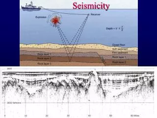
3-D Tomographic InversionActive-Source Data • ~92,000 first arrivals from active source experiments (e.g. SHIPS) • 1200 wide-angle reflection times from SHIPS
US Topography Topographic action mark tectonic activity
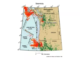
USA seismicity • Notice that all the action is in the West • most dramatic topography in the West • Yosemite, Cascade Mts., Big Sur coast, etc. • few earthquakes in the East • Some faults as far east as Yellowstone • No action to west in Pacific plate either • Hawaii is special case - hot spot volcano
Geology of western US - Fabric related to deformation
Western boundary of North American Plate • Type of boundary depends on orientation • Plate boundaries move and change in time • Past 30 My saw major changes & development of San Andreas Fault • From 80 to 30 My Farallon plate subducted under west coast. • Juan de Fuca & Cocos plates are remnants of Farallon plate
Details: US and Mexico coast • Three little plates subducting offshore Oregon, Washington, and B. Columbia • Juan de Fuca Plate • Gorda Plate • Explorer Plate • Spreading ridge splitting Gulf of California • Separating Baja from N. America • Oblique because ridges are combined with transform faults • Cocos Plate subducting to the south
Exoticterrainplacement Accretion of fragments to continent
Exotic terrains Western N. Am (Cordillera) assembled from small pieces over past 200 My
Changes in west coast • A mid-ocean ridge subducted • Before that, just subduction on coast • First hit near LA 25 Mya • San Andreas fault system started then • As ridge is subducting, two triple junctions are moving apart on coast • Mendocino Triple Junction moving north • NA-Pacific-Juan de Fuca junction • NA-Pacific-Rivera junction off Baja California
Note present San Andreas fault Show movie #02
Oregon-Washington • M 9 every 1000 years, last in 1700 • Recent quakes • M 7.0 in 2000, 6.5 in 1965 in Seattle • M 7.1 in 1949 in Olympia • Main fault is subduction zone • Also volcanoes (like Mt. St. Helens) • Not adequately prepared • We’ve looked at these faults before • But biggest surface offshore
Cascadia subduction zone • 4 cm/yr convergence rate
Pacific - Juan de Fuca spreadingSubduction of J. de F. under N. Am. Iacopi, 27 Note: Plate motions Triple Junctions
Cartoon view Show movie #09
Oregon-Wash.Close-up Note: Volcanoes San Andreas Triple Junctions Mt. Hood From Portland Yeats, 5-2
Subduction under Pacific Northwest • 4 cm/yr of plate convergence • like small convection cell - up at ridge down at subduction zone • Site of great underthrusting earthquakes • None in historic record • But evidence for magnitude 9 quake in 1700 • Tsunami sands in buried marsh • Tsunami in Japan in 1700 • Volcanic arc & eruptions • Mt. St. Helens, Mt. Rainier, Mt. Shasta
Cascadiacross-section Oregon-Washington X-sect Cascade Mts Olympic Mts Ridge Keller, 7-5
Tsunami sand associated with the 1700 earthquake covering a Native fire pit on the banks of the Salmon River in Oregon. Fire-cracked rocks, charcoal and ashes delineate the fire pit that was dug into the sandy beach.
Last 30 Mya of west coast tectonics Cape Mend.
Every 15 months ETS BS Array * Creager & Wech
Tremor Migration for four ETS events Wech, Creager and Melbourne, JGR, submitted
Tremor and Slip summed over 4 ETS events Wech, Creager and Melbourne, JGR, submitted
Episodic Tremor and Slip (McCausland et al., GRL 2005)