Download
1 / 12
120 likes | 219 Vues
This scenario envisions a sustainable community design for Moncton by incorporating Low Impact Design principles and Best Management Practices for stormwater management. The project aims to create a mixed-use development with net-zero houses and buildings, considering environmental constraints and maximizing green spaces. The design includes recreational areas, commercial complexes, and affordable housing options. The proposal focuses on mitigating non-point source pollution impacts and preserving natural habitats, while enhancing the aesthetic appeal of the area.

E N D
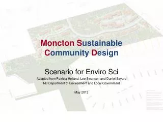
Moncton SustainableCommunityDesign Scenario for Enviro Sci Adapted from Patricia Holland, Lee Swanson and Daniel Savard NB Department of Environment and Local Government May 2012
Property (75.2 ha) to be developed showing environmental and other constraints
INTRODUCTION • The City Council of Moncton (population of 100,000) is willing to allow Max Builder to build at least 50 houses on his property (see attached map). • The Council does not want a conventional subdivision, but one which is based on the concepts of Low Impact Design (LID) and which considers non-point source pollution (NPSP) sources which may impact the site. • The Council would like to see mixed land use and a variety or housing styles.
BACKGROUND INFORMATION • The area of the property is 75.2 hectares. • Max Builder wants to make a profit and include recreational uses and green space within the site. • Max wants to build a minimum of 50 houses, but is interested in building more plus at least one commercial complex. • The commercial building(s) must be situated to allow all modes of transportation to reach them. • There will be a MonctonMart big box store with 200 parking spaces.
BACKGROUND INFORMATION • A community centre will be built on site with 100 parking spaces. • Contour lines on the attached map are 5m. • There is one arterial highway that is heavily used (1,000 vehicles / hour): • Speed limit is 80 km/hour • Ditching is along the highway • Local roads are adjacent to property
BACKGROUND INFORMATION • An elementary school and other commercial services are within 500 m of the site. • The site is currently zoned for 0.5 hectare lots for residential purposes, but the Council would consider different designs, if more sustainable. • A First Nations Community is adjacent to the site, and there is a federal heritage site on the nearby island.
Wetlands BACKGROUND INFORMATION Eagle’s Nest Natural Area • There are two soil types: sand/gravel and clay (see map). • There is an existing trail system that is starting close to the site. • Natural features include (see attached map): • mixed forest, • apple orchard, • wetlands, • streams with Atlantic Salmon / trout, • eagles nest, • deer wintering area, bears, beavers, • butternut trees • forest harvest area • Wind predominantly from the west but north in winter. Historical Farm Scenic View Mature Trees Beaver Dam
BACKGROUND INFORMATION • There is an existing gas bar without surface water controls. • There is a potato farm that has had some soil erosion problems in the past. • Max Builder would like to retain a portion of the site for future wood harvesting.
YOUR TASK • You are a team of resource consultants who have been hired by Max Builder, and you must present a subdivision design option (in general terms) to Moncton City council using LID principles, and Best Management Practices (BMPs) for surface water / stormwater management. • Consideration must also be given for possible NPSP impacts and mitigation measures. • Include streets, houses and other development projects. • Houses and buildings should be net-zero. • Use the map provided as part of your presentation.
ADDITIONAL NOTES • Be aware of and consider the following: • All water that falls on the site has to be treated naturally before being released in the environment. • Sewage and drinking water will be hooked up to the existing municipal sewage and drinking water distribution system. • Future residents must have recreational sites and natural areas, and street networks should be connected.
ADDITIONAL NOTES • Be aware of and consider the following: • Moncton City Council does not want the commercial development to affect the aesthetic value and the surface water quality. • Council would view the project positively if there is 20% of housing that is affordable and if the subdivision is linked to a seniors complex. • Moncton City Council would like to have at least 50% of buildable property conserved as green or natural space (habitat, corridors, trees, wetlands, buffer, water, etc.)