
Upwelling Event in Gulf of Finland - August 2006 Modeling Results
E N D
Presentation Transcript
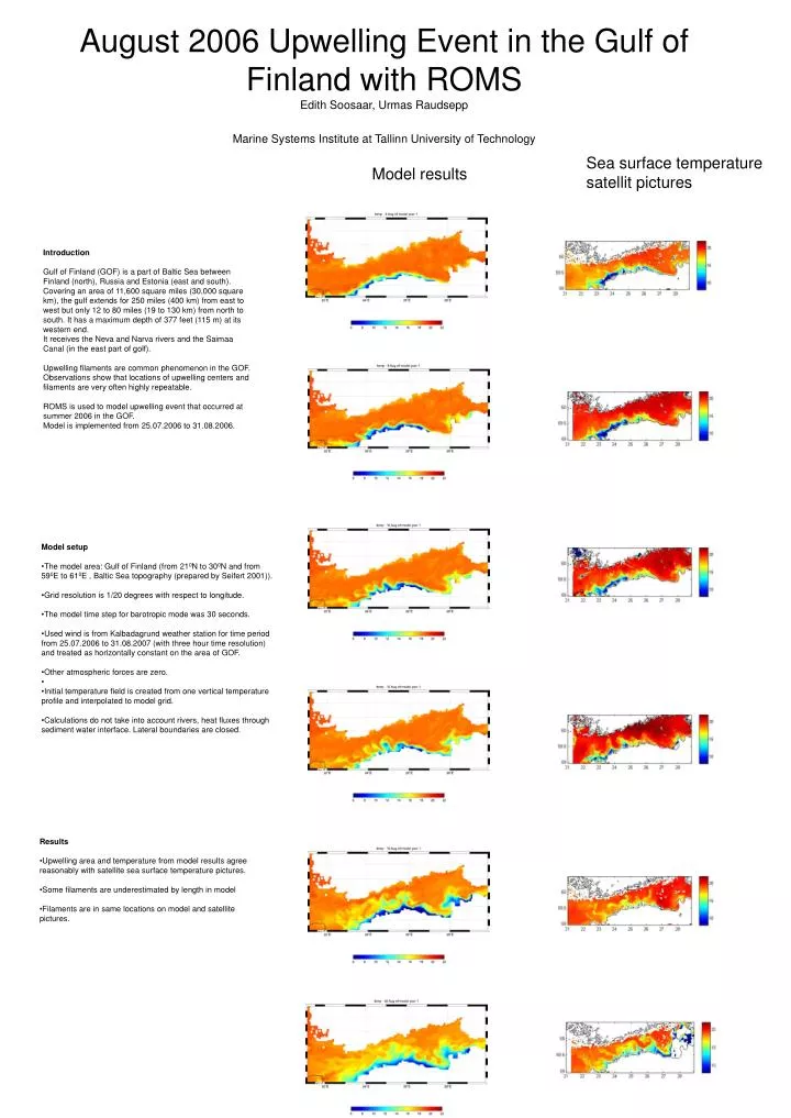
Sea surface temperature satellit pictures Model results August 2006 Upwelling Event in the Gulf of Finland with ROMSEdith Soosaar, Urmas RaudseppMarine Systems Institute at Tallinn University of Technology Introduction Gulf of Finland (GOF) is a part of Baltic Sea between Finland (north), Russia and Estonia (east and south). Covering an area of 11,600 square miles (30,000 square km), the gulf extends for 250 miles (400 km) from east to west but only 12 to 80 miles (19 to 130 km) from north to south. It has a maximum depth of 377 feet (115 m) at its western end. It receives the Neva and Narva rivers and the Saimaa Canal (in the east part of golf). Upwelling filaments are common phenomenon in the GOF. Observations show that locations of upwelling centers and filaments are very often highly repeatable. ROMS is used to model upwelling event that occurred at summer 2006 in the GOF. Model is implemented from 25.07.2006 to 31.08.2006. • Model setup • The model area: Gulf of Finland (from 210N to 300N and from 590E to 610E , Baltic Sea topography (prepared by Seifert 2001)). • Grid resolution is 1/20 degrees with respect to longitude. • The model time step for barotropic mode was 30 seconds. • Used wind is from Kalbadagrund weather station for time period from 25.07.2006 to 31.08.2007 (with three hour time resolution) and treated as horizontally constant on the area of GOF. • Other atmospheric forces are zero. • Initial temperature field is created from one vertical temperature profile and interpolated to model grid. • Calculations do not take into account rivers, heat fluxes through sediment water interface. Lateral boundaries are closed. • Results • Upwelling area and temperature from model results agree reasonably with satellite sea surface temperature pictures. • Some filaments are underestimated by length in model • Filaments are in same locations on model and satellite pictures.