Download
1 / 15
150 likes | 261 Vues
This document outlines the shipboard and remote sensing data activities from the John Ryan Kudela Lab. It details the management of underway shipboard data, CTD measurements, chemical analyses, and QA/QC processes for chlorophyll and nutrient data. Additionally, the document discusses near-real-time satellite data access in collaboration with NOAA. It highlights advancements in database management, including integration with various data providers, and efforts to improve data output for end users. It also notes outreach initiatives and partnerships to address environmental issues related to marine science.

E N D
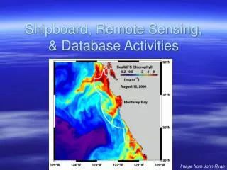
Shipboard, Remote Sensing, & Database Activities Image from John Ryan
Kudela Lab Shipboard Data: - Underway shipboard data (TSG, Fluor) - CTD data (with fluor, ancillary measurements) - Bottle chlorophyll and ancillary measurements - Nutrients (prior to August 2006) Remote Sensing: - NRT access to satellite data - Interface with NOAA through Dave Foley and Rick Stumpf - Process-oriented studies Database: - Took over in 2006 - Interface with Brian Fulfrost, Todd Anderson, Rondi Robison
Shipboard Data • All CTD data through May 2006 consistently reprocessed • Manually inserted surface values, fluor from upcast when necessary • Underway data through July 2005 QA/QC’d • All chlorophyll and nutrient data QA/QC’d • GFF, 1 µm, 10 µm, Nitrate, Phosphate, Silicate • Ancillary data in various stages of processing
Remote Sensing • Near-Real Time data available @ • http://oceandatacenter.ucsc.edu/NRT/ • Also from CIMT webpage • Complete dataset from Rick Stumpf for SeaWiFS (1997-2005) available • Better cloud-masked data for CoastWatch SST available • Working on iterative EOF method to develop cloud-free imagery
Mean chlorophyll, Monterey Mean 2003
Chlorophyll, Monterey, coastal & offshore Coastal Offshore
CIMT Database Activities • Took over as lead in 2005/2006 • Progress: • Mapped existing MySQL database • Moved to new hardware, with backup • Todd Anderson has been keeping the LAS up • Collecting data from data providers for update • To Do: • Hire database support person • Probably move to PostGres for better mapserver support • Working with Brian Fulfrost and Rondi on data output
Moving from Science to End-Users • Established collaboration with CCLEAN • Added urea, ammonium measurements for 2006 • Mapping satellite data to river flow • Outreach to Dave Jessup @ OSPRS • Providing customized satellite imagery • Working with them on non-point source pollution issues • Working with CDHS, provided backround and imagery to Animal Planet, Sea Studios • NOAA is interested in testing improved GNOME model for event tracking