Download
1 / 31
310 likes | 514 Vues
Critical Cause Analysis of Delayed Evacuation in the Great East Japan Earthquake and Tsunami. IRDR International Conference, Beijing 1 November, 2011 Junko Sagara CTI Engineering Co., Ltd. Japan ICHARM International Centre for Water Hazard Risk Management under the auspices of UNESCO.

E N D
Critical Cause Analysis of Delayed Evacuation in the Great East Japan Earthquake and Tsunami IRDR International Conference, Beijing 1 November, 2011 Junko Sagara CTIEngineering Co., Ltd. Japan ICHARM International Centre for Water Hazard Risk Management under the auspices of UNESCO
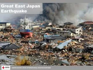
Forensic Investigation onGreat East Japan Earthquake and Tsunami (GEJET) 2
Objectives • Preliminary effort to conduct FORIN analysis of Great East Japan Earthquake and Tsunami. • Investigate how the delay in evacuation from tsunami occurred, and how it lead to enormous human losses. • Identify critical points for considering vulnerability of communities against human losses caused by delayed evacuation from tsunami. • Overview of the Great East Japan Earthquake and Tsunami (GEJET) • Critical causes analysis of human losses due to delayed evacuation • Case Study of Rikuzentakata • Conclusion Outline
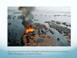
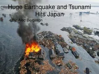
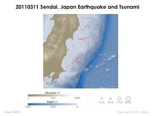
1. Great East Japan Earthquake and Tsunami (GEJET) • M9.0 earthquake occurred on March 11, 2011 at 14:46 • Massive ground motion was observed throughout Japan • Mega-tsunami of about 1,000 year return period and subsidence led to enormous damages • Complex disaster (earthquake, tsunami, nuclear accident) • Historic Tsunami Events in the region • 1897:[M8.5] 21,959 dead • 1933: [M8.1] 3,064 dead or missing Seismic Intensity Japan Meteorological Agency
Overview of Damages • Inundated area by tsunami:561km2 • Human casualties: 15,829 dead, 3,745 missing, 5,942 injured (as of Oct 25) • Building damages: 118,790 completely destroyed, 184,343 half destroyed, 280 burned down, 10,961 inundated (above floor), 13,867 inundated (below floor) • Agricultural land losses: 23,600ha • Direct damages to infrastructure stock: approx. 16.9 trillion yen (US$200 billion, estimated by cabinet office, not including damages caused by nuclear accident) Hirono(0) Kuji(4) Noda(38) Fudai(1) Tanohata(31) Iwaizumi(7) Tarou(180) Iwate Miyako(362) Yamada(823) Otsuchi(1,397) Kamaishi(1,091) Ofunato(452) Rikuzentakata(1,951) Kesennuma(1,405) Miyagi Minamisanriku(901) Higashimatsushima(1,145) Ishinomaki(3,959) Matsushima(2) Rifu(50) Onagawa(963) Shiogama(21) Shichigahama(71) Tagajou(189) Miyagino-ku, Sendai(293) Taihaku-ku, Sendai(53) Natori(984) Wakabayashi-ku, Sendai(332) Iwanuma(184) Watari(270) Fukushima Yamamoto(691) Shinchi(110) Soma(459) Minamisoma(663) Namie(184) Futaba(35) Okuma(81) Tomioka(25) National Police Agency (As of Oct 25, 2011) 2011 White Paper on Disaster Management Naraha(13) Hirono(3) Iwaki(347) Human losses in coastal municipalities Fire and Disaster Management Agency (As of Sept 9, 2011)
Human Losses • 92.4% of people died in Iwate, Miyagi and Fukushima lost their lives due to tsunami. Tsunami was the main cause of death Crushed by buildings, etc 4.4% Unknown 2% Fire 1.1% 65% of fatalities were 60 years or older Tsunami 92.4% Death causes in GEJET (Iwate, Miyagi & Fukushima) Source: 2011 White paper on disaster management Age structure of population and people died in GEJET (Iwate, Miyagi & Fukushima)
2. Critical cause analysis of human losses due to delayed evacuation Why were so many people not able to escape from the tsunami? The critical points for human losses and delayed evacuation were analyzed by reviewing various reports published after GEJET.
Magnitude of Tsunami in GEJET % of people died or missing in inundated area Tsunami height exceeded twice the height of coastal levees Iwate Tarou: levee height10m, tsunami height 15.5m, run-up height approx. 38m (Number of fatalities & missing) / (population in inundated area) Otsuchi: levee height 6.4m, tsunami height 12.9m Miyagi Rikuzentakata: levee height 6.15m, tsunami height 16.4m Fukushima Onagawa: levee height 4.4m, tsunami height 15.9m ※ levee height and tsunami trace height near the levee in front of the coastal cities and towns were plotted from the maps produced by the Tohoku regional bureau of MLIT. Fire and Disaster Management Agency (As of Sept 9, 2011)
Effectiveness of Structural Measures Structural measures proved to be effective and protected lives in certain areas • Coastal levee (T.P.+12.0m)was higher than the tsunami height (tsunami run-up height T.P.+9.5m) Hirono, Iwate Fudai, Iwate • City located far from the coast was protected by the gate. Town center No inundation Inundated area Fudai Gate Fudai Gate Levee height T.P.+12.0m Inundation height near the gate T.P.+22.6m Estimated overflow depth 7.2m Gate height T.P.+15.5m Tsunami height T.P.+9.5m Source: The Expert Panel on Earthquake and Tsunami Countermeasures in Light of the Lessons Learned from the 2011 Tohoku-Pacific Ocean Earthquake Upstream of the gate
Effectiveness of Structural Measures • The greater the tsunami height compared to the levee height the greater the human losses. • Many other factors influenced the extent or severity of human losses . Taro Rikuzentakata Otsuchi Onagawa Tanohata (urban center located far from the coast) ※ levee height and tsunami trace height near the levee in front of the coastal cities and towns were plotted from the maps produced by the Tohoku regional bureau of MLIT. % Human loss based on the data announced on Sept 9 2011 by the Fire and disaster Management Agency
Flow of Human Losses due to delay in evacuation Flow of human losses due to delay in evacuation in case of tsunami to identify the critical points for human loss expansion. Evacuation shelter not stricken by tsunami Fundamental action to be taken by people Escaped from tsunami Critical Point 1 Immediate recognition of necessity to evacuate Arrived at evacuation shelters Evacuated Critical Point 5 Safety of evacuation shelters self-judged Critical Point 4 Obstacles during evacuation info-reactive follow others Critical Point 6 Detection of danger and progressive evacuation Evacuation shelter stricken by tsunami Warning accessible Critical Point 3 Evacuation actions Did not arrive at evacuation shelters Caught by tsunami Critical Point 2 Accurate evacuation warning/ information quake Did not evacuate Warning not accessible
CP1 Immediate recognition of necessity to evacuate About half of the people who survived tsunami evacuated immediately after the earthquake. Critical Point 1 Immediate recognition of necessity to evacuate Evacuated self-judged Did not evacuate (already in safe area) Evacuated only after noticing that tsunami was approaching Evacuated after completing other actions Immediately evacuated quake Timing of Evacuation Source: The Expert Panel on Earthquake and Tsunami Countermeasures in Light of the Lessons Learned from the 2011 Tohoku-Pacific Ocean Earthquake
CP1 Immediate recognition of necessity to evacuate • People who evacuated only after noticing that tsunami was approaching didn’t evacuate immediately because “tsunami didn’t occur in past earthquakes” or “tsunami never came up to their mind” ※1 • In Miyagi, about half of the people survived thought tsunami wouldn’t come or didn’t think about tsunami. Only 4% had seen tsunami hazard maps. ※2 Even among those who survived, many were not aware of tsunami risks. Critical Point 1 Immediate recognition of necessity to evacuate Evacuated self-judged quake Source: ※1: The Expert Panel on Earthquake and Tsunami Countermeasures in Light of the Lessons Learned from the 2011 Tohoku-Pacific Ocean Earthquake ※2: Survey Research Center “宮城県沿岸部における被災地アンケート” May 2011
CP1 Immediate recognition of necessity to evacuate • Many of the people that didn’t immediately evacuate were out of their homes. Instead of evacuating they went back home or went out to look for their families. ※1 • The disaster occurred during the day time when family members were scattered. People worried about the safety of their family and moved immediately to get together with their family members. ※2 Because the tsunami occurred during the day, many were away from home. Instead of evacuating people went searching for their family members. Critical Point 1 Immediate recognition of necessity to evacuate Evacuated self-judged quake Source: ※1: The Expert Panel on Earthquake and Tsunami Countermeasures in Light of the Lessons Learned from the 2011 Tohoku-Pacific Ocean Earthquake ※2: Survey Research Center “宮城県沿岸部における被災地アンケート” May 2011
CP1 Immediate recognition of necessity to evacuate • Risk or danger of tsunami and necessity to evacuate not recognized by all people. • Many prioritized actions to search for their family members over evacuation. • Disaster education in schools proved very effective. Disaster education and evacuation procedures in schools proved to be very effective, saving lives of school children. Critical Point 1 Immediate recognition of necessity to evacuate Evacuated self-judged Very small human loss rate in ages of 5 to 14 quake Source: ※1: The Expert Panel on Earthquake and Tsunami Countermeasures in Light of the Lessons Learned from the 2011 Tohoku-Pacific Ocean Earthquake ※2: Survey Research Center “宮城県沿岸部における被災地アンケート” May 2011
CP2: Accurate evacuation information • Average time required to obtain tsunami warning or advisory was 16.4 minutes. ※1 • In tsunami prone areas 13% did not know that tsunami warning was announced. ※1 • Many of usual communication methods became inaccessible due to power outage, overwhelmed phone lines, etc※2 • Underestimated preliminary forecast was misinterpreted as “safe”. ※3 • Due to power outage, updated information was not accessible. ※3 • Accurate and most up-to-date tsunami warning information was not accessible for many people due to power outage, etc. • Underestimated preliminary forecast lead to misconception that it is “safe”. Critical Point 1 Immediate recognition of necessity to evacuate Evacuated self-judged Warning accessible Critical Point 2 Accurate evacuation warning/ information quake Source: ※1 weathernews “Survey Results of Great East Japan Earthquake and Tsunami”(April 2011) ※2 Crisis and Environment Management Policy Institute “Preliminary Report on the Survey on Tohoku Pacific Ocean Earthquake and Tsunami” (May 2011) ※3Japan Meteorological Agency “Issues with regard to improvement of tsunami warning “ (June 2011) Warning not accessible
CP3: Evacuation actions • In average it took 17 minutes to begin evacuation. Almost 80% evacuated with others, 53% with their family members. ※1 • Among people who heard evacuation warnings clearly from disaster management radio, 70 to 80% felt the necessity to evacuate. ※2 • Many people lost their lives while convincing or guiding other people to evacuate, including over 300 fire and disaster department staffs, fire fighters and police officers delivering evacuation warnings or guiding evacuation. ※3 • Evacuation warnings and evacuation advices by neighbors and families triggered evacuation actions for many people. Critical Point 1 Immediate recognition of necessity to evacuate Evacuated self-judged info-reactive follow others Warning accessible Critical Point 3 Evacuation actions Critical Point 2 Accurate evacuation warning/ information quake Did not evacuate Source: ※1: The Expert Panel on Earthquake and Tsunami Countermeasures in Light of the Lessons Learned from the 2011 Tohoku-Pacific Ocean Earthquake ※2: Survey Research Center “宮城県沿岸部における被災地アンケート” May 2011 ※3: Fire and Disaster Management Agency, National Police Agency Warning not accessible
CP4: Obstacles during evacuation • 60% evacuated by cars and 1/3 were caught in traffic. ※1 • Many used cars because they thought otherwise they wouldn’t make it, or they wanted to evacuate with family members. ※1 • In Miyagi, many people older than 60 or women used cars. Among those caught in traffic, only 7.3% changed the mean of transportation. ※2 Many evacuated using cars and got trapped in traffic. Critical Point 1 Immediate recognition of necessity to evacuate Arrived at evacuation shelters Evacuated self-judged Critical Point 4 Obstacles during evacuation info-reactive follow others Warning accessible Critical Point 3 Evacuation actions Did not arrive at evacuation shelters Critical Point 2 Accurate evacuation warning/ information quake Did not evacuate Source: ※1: The Expert Panel on Earthquake and Tsunami Countermeasures in Light of the Lessons Learned from the 2011 Tohoku-Pacific Ocean Earthquake ※2: Survey Research Center “宮城県沿岸部における被災地アンケート” May 2011 Warning not accessible
CP4: Obstacles during evacuation • Use of cars during evacuation caused traffic congestion and many got trapped. • Pre-installed tsunami emergency routes in schools proved very effective. Evacuation routes played big role in securing safety of people, especially school children. Critical Point 1 Immediate recognition of necessity to evacuate Arrived at evacuation shelters Evacuated self-judged Critical Point 4 Obstacles during evacuation info-reactive follow others Warning accessible Critical Point 3 Evacuation actions Emergency route from the second floor of Okirai Elementary School Did not arrive at evacuation shelters Critical Point 2 Accurate evacuation warning/ information quake Did not evacuate Emergency route from Omoto Elementary School to national route highway Warning not accessible Source: Asahi Newspaper Iwaizumi Town Paper (April 2011)
CP5: Safety of evacuation shelters • In 11 cities of Iwate prefecture 48 evacuation shelters out of 411 were inundated. ※1 • In Onagawa Town, reinforced concrete buildings often used as evacuation shelters were collapsed from the foundation. ※2 • Safety (location and structural) of evacuation shelters was insufficient in some cases Evacuation shelter not stricken by tsunami Critical Point 1 Immediate recognition of necessity to evacuate Arrived at evacuation shelters Evacuated Critical Point 5 Safety of evacuation shelters self-judged Critical Point 4 Obstacles during evacuation info-reactive follow others Evacuation shelter stricken by tsunami Warning accessible Critical Point 3 Evacuation actions Did not arrive at evacuation shelters Critical Point 2 Accurate evacuation warning/ information quake Did not evacuate Source: ※1 Kahoku Shinpo (April 14, 2011) ※2 Japanese Society of Civil Engineers Emergency Investigation Group Report Warning not accessible
CP6: Detection of danger and progressive evacuation • Among those who evacuated from tsunami in Miyagi, 60.8% evacuated from the primary evacuation shelter to the next. Among them 55.5% said the first shelter was stricken by tsunami. ※1 • For most people the primary evacuation shelter was “publicly designated shelter such as community centers and schools”. About 40% moved further to evacuate to higher elevation or safer facilities. ※2 • Many evacuated to safer location regardless of the designated shelters. Evacuation shelter not stricken by tsunami Escaped from tsunami Critical Point 1 Immediate recognition of necessity to evacuate Arrived at evacuation shelters Evacuated Critical Point 5 Safety of evacuation shelters self-judged Critical Point 4 Obstacles during evacuation info-reactive follow others Critical Point 6 Detection of danger and progressive evacuation Evacuation shelter stricken by tsunami Warning accessible Critical Point 3 Evacuation actions Did not arrive at evacuation shelters Caught by tsunami Critical Point 2 Accurate evacuation warning/ information quake Did not evacuate Source: ※1: The Expert Panel on Earthquake and Tsunami Countermeasures in Light of the Lessons Learned from the 2011 Tohoku-Pacific Ocean Earthquake ※2: Survey Research Center “宮城県沿岸部における被災地アンケート” May 2011 Warning not accessible
Check List to assess Human Loss Vulnerability Evacuated ・Self-judged ・Info-reactive ・Following others Evacuation shelter was not stricken by tsunami Accurate evacuation information accessible Arrived at evacuation shelters Escaped from tsunami quake CP1: Immediate recognition of necessity to evacuate CP2: Accurate evacuation warning/info CP3: Evacuation actions CP4: Obstacles during evacuation CP5: Safety of evacuation shelters CP6: Detection of danger and progressive evacuation Accurate evacuation information not accessible Did not arrive at evacuation shelters Evacuation shelter stricken by tsunami Did not evacuate Caught by tsunami • Is the risk of tsunami recognized from past tsunami disasters or hazard maps? • Are methods of safety confirmation among family members ensured? • Are there ways to disseminate tsunami warnings or evacuation information? • Are there ways to disseminate information at once? • Is information accessible during power outage? • Is information disseminated received/understood by people appropriately? • Are there community efforts to promote evacuation among neighbors? • Is the safety of officers providing evacuation guidance ensured? • Is the evacuation route safety ensured? • Are people aware of the location of evacuation shelters? • Are evacuation shelters located in ways so that people can walk to shelters? • Are there emergency routes secured that ensure immediate evacuation to higher elevation? • Is the safety of evacuation shelter ensured (height & structural safety)? • In flat areas far from hills, are there safe evacuation shelters (such as tsunami evacuation buildings) designated? • Are people provided with disaster education to evacuate to safer places regardless of designated evacuation shelters? • Can the real time tsunami information be obtained to detect danger early?
3.Case Study of Rikuzentakata City • Approx. 2,000 persons (10% of total population) are dead or missing in Rikuzentakata Buildings destroyed3,159 Dead and missing2,191 Inundated area1,300ha Population in inundated area16,640 # households in inundated area 5,592 Rikuzentakata City Hall Rikuzentakata City Hall was devastated by tsunami Tsunami submerged up to 4th floor Red :Inundated Area
Flow of Human Losses in Rikuzentakata • Only 33 out of 180 immediately evacuated. Out of 33 only 1 died. ※1 • Among those who didn’t immediately evacuate half didn’t think tsunami would arrive to their location ※1 • Among 147 that didn’t immediately evacuate 1/3 (42) died. ※1 Lack of awareness regarding tsunami risks lead to delay in evacuation. Evacuation shelter not stricken by tsunami Escaped from tsunami Arrived at evacuation shelters Evacuated self-judged info-reactive follow others Evacuation shelter stricken by tsunami Warning accessible Did not arrive at evacuation shelters Source: ※1: 陸前高田市における東日本大震災大津波襲来時の住民行動-将来の防災へ向けて― ICHARM, UNESCAP Caught by tsunami quake Did not evacuate Warning not accessible
Flow of Human Losses in Rikuzentakata • Examination of bodies indicated that many had finished evacuation or were in the midst of evacuation. ※2 • Number of designated evacuation shelters were located within the inundated area and many died at the evacuation shelters. ※1 • Out of 68 primary evacuation shelters 35 were inundated by tsunami. ※2 Safety of evacuation shelters was not secured. Evacuation shelter not stricken by tsunami Escaped from tsunami Arrived at evacuation shelters Evacuated self-judged info-reactive follow others Evacuation shelter stricken by tsunami Warning accessible Did not arrive at evacuation shelters Source: ※1: 陸前高田市における東日本大震災大津波襲来時の住民行動-将来の防災へ向けて― ICHARM, UNESCAP Caught by tsunami quake Did not evacuate City Gymnasium was a designated evacuation center but was inundated to 14m depth. 100 persons evacuated to this facility and most of them lost their lives. Warning not accessible
Flow of Human Losses in Rikuzentakata Evacuation shelter not stricken by tsunami Escaped from tsunami Arrived at evacuation shelters Human loss of younger generations could be explained by the fact that many lost their lives at evacuation shelters upon completion of evacuation Evacuated self-judged info-reactive follow others Evacuation shelter stricken by tsunami Warning accessible High % human loss of younger generations in Rikuzentakata Did not arrive at evacuation shelters Caught by tsunami quake Did not evacuate Warning not accessible
Critical Causes for Human Losses in Rikuzentakata • Lack of awareness regarding tsunami risks • Hazard maps • Urban development in areas of high tsunami risks(revealed by Meta Analysis) • Inappropriate designation of evacuation shelters
4.Conclusion • The critical causes for human losses vary depending on the physical settings and social characteristics of the communities, and the extent of tsunami prevention/preparedness measures (both structural and non-structural). • The current FORIN template is useful in obtaining the in-depth and exhaustive picture of the phenomenon of the disaster and its impact. But to do this in full scale it would require much time and resources. • In order to identify critical causes or bottlenecks for certain area, utilization of hierarchical check list as prepared in this study could be useful. • An investigation sheet consisting of check list can be prepared for different entities (administrator, community, general public, etc. ) to measure their vulnerability against disasters. Such tool could assist identifying weakness or necessity for future measures.
Example of human loss vulnerability review sheet (municipality) Evacuated ・Self-judged ・Info-reactive ・Following others Evacuation shelter was not stricken by tsunami Accurate evacuation information accessible Arrived at evacuation shelters Escaped from tsunami quake CP1: Immediate recognition of necessity to evacuate CP2: Accurate evacuation warning/info CP3: Evacuation actions CP4: Obstacles during evacuation CP5: Safety of evacuation shelters CP6: Detection of danger and progressive evacuation Accurate evacuation information not accessible Did not arrive at evacuation shelters Evacuation shelter stricken by tsunami Did not evacuate Caught by tsunami • Is a tsunami hazard map being prepared? • Are there programs implemented to enhance disaster awareness of residents? • Is disaster awareness education provided at schools? • Are there ways to disseminate tsunami warnings or evacuation information? • Are there ways to disseminate information at once? • Is information accessible during power outage? • Is a tsunami hazard map being prepared appropriately? • Are there programs implemented to enhance disaster awareness of residents(evacuation drills, etc)? • Is disaster awareness education provided at schools? • Is information disseminated received/understood by people appropriately? • Are there community efforts to promote evacuation among neighbors? • Is the safety of officers providing evacuation guidance ensured? • Is the evacuation route safety ensured? • Are people aware of the location of evacuation shelters? • Are evacuation shelters located in ways so that people can walk to shelters? • Are there emergency routes secured that ensure immediate evacuation to higher elevation? • Is the safety of evacuation shelter ensured (height & structural safety)? • In flat areas far from hills, are there safe evacuation shelters (such as tsunami evacuation buildings) designated? • Are people provided with disaster education to evacuate to safer places regardless of designated evacuation shelters? • Can the real time tsunami information be obtained to detect danger early?
Additional Suggestions to FORIN Question List • In the GEJET many infrastructure services were impacted in enormous scale. Propagation of damages among infrastructure and its impact to socio economic activities are critical issue. • By knowing critical points in damage propagation, effective measures could be implemented to mitigate propagation of damages and to minimizing extent of impacts. • Further questions could be added to the FORIN Questions List. • What were the consequences of breakdown or malfunctioning of infrastructure networks (e.g., electricity, water supply, sewerage, transportation, communication, health services, educational services, etc) ? • How did the effect on an infrastructure network propagate to another infrastructure network? • How were the economic activities of the affected area impacted and how did it propagate to other areas/regions? • What actions were taken in order to compensate the infrastructure or service network failure . • How were the infrastructure or service networks restored?