Download
1 / 61
610 likes | 803 Vues
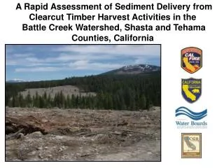
A Rapid Assessment of Sediment Delivery from Clearcut Timber Harvest Activities in the Battle Creek Watershed, Shasta and Tehama Counties, California. SPI uses extensive clearcut harvesting Concerned environmental stakeholders in the watershed. (Sacramento Bee, 2011).

E N D
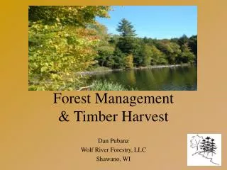
A Rapid Assessment of Sediment Delivery from Clearcut Timber Harvest Activities in the Battle Creek Watershed, Shasta and Tehama Counties, California
SPI uses extensive clearcut harvesting • Concerned environmental stakeholders in the watershed (Sacramento Bee, 2011)
Article implied clearcutting is causing water quality impacts to Battle Creek • Is the permitting of clearcutting running counter to goals and objectives of Restoration Project? (Sacramento Bee, 2011)
Battle Creek Task Force Formed • Task Force staffed by two members from following THP Review Team agencies: • Central Valley Regional Water Quality Control Board; • California Department of Fish and Game; • California Geological Survey; and • CAL FIRE. • Subject matter experts with decades of combined field experience in forestry-water-fish issues
Purpose Statement: Evaluate whether timber operation associated with SPI clearcut harvesting in Battle Creek has resulted in observable erosion and subsequent delivery of sediment which has resulted in violation of state law or observable negative impacts to fisheries.
Water Quality Impacts From Timber Harvest A Function Of: • Proximity of activity to stream • Erosion potential of activity
Proximity of Erosion Source to Stream (Croke and Hairsine, 2006)
Erosion Potential of Activity Gully Erosion to a Class III watercourse
Surface Cover Removal High Risk Very Little Erosion Anything Can Happen (Larsen and others, 2009)
Flowpath Modification (R. Ettner, Siskiyou National Forest)
Potential Impacts from Overstory Removal Post- Clearcut Discharge Pre- Clearcut Time (Jones and Grant, 1996)
Site Selection • Placed highest priority on clearcuts with buffers on fish-bearing streams (Class I WLPZs); • Other prioritization criteria: • Time since operation (at least one season of overwintering) • Tractor logging • Steeper slopes • More erodible soils (e.g., rhyolite-derived soils)
Methods • Walk the interface between clearcut and riparian buffer to look for sediment delivery (Litschert and MacDonald, 2009); • Visit pre-identified road crossings, tractor crossings, and landings; • Walk watercourse-adjacent road segments.
Methods • Identify if sediment was delivered to watercourse; • Evaluate relative magnitude of sediment delivery: • Low (< 1 yd3) • Moderate (1 to 10 yd3) • High (> 10 yd3) • Characterize erosion; • Identify erosion source.
Road Crossings • Sediment delivery generally came from crossing approaches • Privately-maintained road behind gates generally delivered little sediment • Publicly-maintained roads and roads with public access had higher likelihood of delivering moderate magnitudes of sediment
Watercourse-AdjacentRoad Segments • Segments most likely to deliver when they were within 30 feet of watercourse • Roads with moderate to high magnitudes of sediment delivery were within 5 to 20 feet • Sediment delivery often unmitigatible
Tractor Crossings and Landings • All tractor crossings deliver at least a low magnitude of sediment • Difficult to return channel to pre-logging condition • Delivery limited by general lack of tractor crossings • Landings generally delivered no sediment due to ample surface cover provided by chipping operations
BMPs Effective in PreventingDirect Sediment Delivery from Clearcuts • Strategic skidding and effective drainage (waterbars) limits runoff production and erosion; • Contour ripping decreases compaction, increases infiltration, and decreases slope length; • Surface cover remains relatively high (typically greater than 75%); • Sediment-laden runoff routed to areas relatively undisturbed by heavy machinery; • Buffer strips effective at infiltrating runoff and filtering sediment.
Is This An Anomaly? • Litschert and MacDonald (2009) assessed 180 miles of stream buffer adjacent to timber harvest units, including clearcuts, in Sierra Nevada and Southern Cascades; • Found only 6 erosion features that delivered to watercourses.
Linkage to Fish Habitat • Clearcuts not causing observable negative impacts to fisheries habitat • Roads may be causing chronic sedimentation • Further study and monitoring needed
Assessment Limitations • Unable to look at indirect impacts of clearcutting: • Clearcutting can increase peak-flow magnitude and duration, potentially resulting in: • Increases in suspended sediment and turbidity • Channel changes – increased bank erosion and/or gully erosion
Assessment Limitations • Depends on forensic evidence available in field: • Erosion features can be transient • Erosion features can be modified by subsequent management • Assessment area not subject to stressing storm events during recent harvest activity • Time frame coincides with turbidity data • collected by BCA
Conclusions (1) • No significant direct water quality impacts related specifically to harvest within clearcuts units • Most sediment delivery comes from road crossings and watercourse-adjacent road segments • Higher magnitudes came from publicly-accessed road (e.g., county roads, ungated roads)
Conclusions (2) • Violations of Forest Practice Rules occurred but generally rare and appeared to be of relatively minor significance to salmonids • Did not assess indirect water quality impacts from clearcuts • Water quality impacts due to logging-induced changes in hydrology remains an open question in young volcanic terranes such as the Battle Creek watershed
Questions? (http://www.battle-creek.net/)
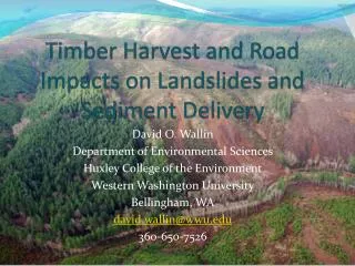
Culvert Initiated Gully Delivering Sediment to the SF Battle Creek - Ponderosa Way