Download
1 / 7
70 likes | 1.45k Vues
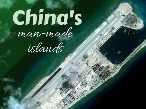
Satellite images of China's man-made islands in the South China Sea.

E N D
Subi reef, located in the disputed Spratly Islands in the South China Sea, is shown in a satellite image taken August 8, 2012. A U.S. guided-missile destroyer sailed close to one of China's man-made islands in the South China Sea, drawing an angry rebuke from Beijing, which said it had tracked and warned the ship and called in the U.S. ambassador to protest. REUTERS/CSIS Asia Maritime Transparency Initiative/DigitalGlobe
Fiery Cross reef, located in the disputed Spratly Islands in the South China Sea, in a satellite image taken September 3, 2015. Construction on the Fiery Cross Reef island includes a Chinese airstrip and port facility, according to the Center for Strategic and International Studies. REUTERS/CSIS Asia Maritime Transparency Initiative/DigitalGlobe
Mischief reef in a satellite image taken September 8, 2015. Mischief Reef, located 135 miles west of the Philippine island of Palawan, is in the exclusive economic zone of the Philippines. REUTERS/CSIS Asia Maritime Transparency Initiative/DigitalGlobe
Fiery Cross reef in a satellite image taken January 22, 2006. Military facilities on Fiery Cross Reef, including a 3,000-metre (10,000-foot) runway, could be operational by year's end, one U.S. commander told Reuters, and Washington is concerned China will use the facilities to press its extensive territorial claims at the expense of weaker rivals. REUTERS/CSIS Asia Maritime Transparency Initiative/DigitalGlobe
Subi reef in a satellite image taken September 3, 2015. Occupied since 1988, Subi Reef was expanded through reclamation beginning in 2014. At night, lights from Subi are visible on the Philippine-held island of Thitu, 13 miles away. REUTERS/CSIS Asia Maritime Transparency Initiative/DigitalGlobe
Mischief reef in a satellite image taken January 22, 2006. REUTERS/CSIS Asia Maritime Transparency Initiative/DigitalGlobe