Download
1 / 33
330 likes | 348 Vues
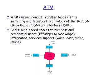
This workshop discusses the development and implementation of measures to renovate air traffic systems, including satellite-based navigation, trajectory-based operation, situational awareness, high-density operation, improved predictability, information sharing, and collaborative decision-making. It also focuses on enhancing aviation weather observation and forecast capabilities.

E N D
WWRP CAS/CAeMAvRDP Workshop MET ATM under CARATS Collaborative Actions for Renovation of Air Traffic Systems October 2018 Yuki Kato Japan Meteorological Agency (JMA)
Consideration of long-term vision • 2009~2010Development of long-term vision • Establishment of “Study group for Promoting Renovation of the Air Traffic System” • Development and promulgation of “Collaborative Actions for Renovation of Air Traffic Systems” (CARATS) • 2010~2011Development of roadmap for each measures • Establishment of “Committee for Promoting Renovation of the Air Traffic System” • Consideration of concrete measures and development of roadmap • 2011 ~Implementation Phase
Working Frameworkin2018 Committee for Promoting Renovation of the Air Traffic System Cost-effectiveness analysis / performance assessment Subgroup PlanningandCoordinationMeeting Research and Development promoting Subgroup MET WG Information Management WG Time Based Traffic Flow Management WG PBN WG ATM WG Communication ad-hoc Advance PBN SG General Aviation PBN SG TBO ad-hoc GNSS ad-hoc surveillances ad-hoc PBN: Performance Based Navigation • There are five working groups and relevant ad-hoc groups and sub groups. • All of the groups carry out collaborative activities between airlines, research institutes, manufactures, JCAB, JMA and other government organizations. • Assessments with cost-benefit analysis are required before implementation of each measure.
Objectives of CARATS and Development of performance indicators Development of indicators for checking the status of implementation of the CARATS measures Progressing CARATS measures steadily and monitoring and analyzing them continuously Objectives to be achieved by 2025 (clarifying numerical targets)
Direction of renovation in CARATS 4. Realizing Satellite-based Navigation for All Flight Phases Aircraft can determine position and time accurately in all FIR of Japan by Satellite-based navigation 3. Promoting Performance-based Operation (PBO) 1. Realizing Trajectory-based Operation (TBO) Fly regularly on a pre-coordinated trajectory from departure to arrival 5. Enhancing Situational Awareness on the Ground and in the Air Cooperation between ground and air, Information sharing Accurate time-based management Integrated ATC processing system 8. Realizing High-density Operation in Congested Airports and Airspace 6 Making Maximum Use of the Capability of Human Beings and Machines 2. Improving Predictability The calculation of air traffic control capacity, Estimation of traffic flow, Improving of predictability of meteorological phenomena 7. Complete information-sharing and Collaborative Decision-Making
Measures of aviation weather in CARATS CARATSRoadmap operational improvements:OI • (improve operation) enablers:EN (technology for enabling OI) Measures of aviation weather ALL Measures of aviation weather are enablers (EN) Improved weather observation capabilities ・Integration of observation data around aerodrome and air spaces Improved weather forecast capabilities ・Development of NWP model with high frequency and resolution ・Expansion of forecast elements Quantification of the impact of severe weather on capacity and other aircraft operations ・Estimation of impact on ATM using MET information ・Translation from MET data to airport/airspace capacity MET information sharing infrastructure ・Sharing of weather information with standardized format on SWIM environment
CARATS Roadmap The roadmap specifies 64 measure that needs to be taken in order to achieve the CARATS, and categorizes them into measures intended to improve operation (operational improvements (OI)) and measures relating to technology necessary for enabling such improvement (enablers (EN)). Please note that following table may different from current version.
Roadmap OI (1) OI (operational improvements): measures intended to improve operation.
Roadmap EN (1) EN (enablers): measures relating to technology necessary for enabling OI.
Roadmap EN (2) MET
Examples of the recent activities on MET in CARATS Improved weather observation capabilities ALWIN (Airport Low-level Wind INformation) Airline ACARS datalink ACARS System RADAR LIDAR Airplane HND and NRT Text Data Wind information for pilots Data transmission System in JMA (ADESS) Flight crew can check wind condition on flight path in cockpit Airport Doppler Radar Administration System In JMA(ADRAS) Graphic Data Real time data of 6 sec intervals Website of Aviation weather information in JMA (MetAir) Anemometer Wind information for operation staff • Wind information detected by Doppler RADAR and LIDAR and measured by anemometer is converted into both graphic data and text data. • Text data is transmitted to pilots in cockpits via the ACARS system. • Airline operators can obtain graphic and text data from dedicated website (MetAir).
Examples of the recent activities on MET in CARATS Improved weather forecast capabilities Probabilistic forecast using NWP, e.g. TB index Development of high resolution NWP model Grid size: 5 km Grid size: 2 km Use of aircraft data via data-link DAPs : Downlink Aircraft Parameters
Examples of the recent activities on MET in CARATS MET integration into ATM decision support system Current ATMet Category Forecast Contribution to more accurate ATM operation, CDM, etc. Other Information Predicted air traffic capacity of airports and airspace based on weather forecast etc. Conversion to air traffic capacity of airports and airspace MET Information ATM officer Airline operator Advanced product using Himawari-8 CBA: Cumulonimbus Areas MLUA: Mid/Low Cloud Unknown Areas RDCA: Rapidly Developing Cumulus Areas 09:00 UTC 09:10 UTC 09:20 UTC
Detailed examples of the recent activities on MET in CARATS Improvement of Low-Level Wind Information ALWIN (Airport Low-level Wind INformation) 18
Detailed examples of the recent activities on MET in CARATS (1) Conventional Low-level Windshear Information of JMA Wind Shear (WS) affects airplane safety operation WS Observation in all weather conditions (from 1996) (from 2008) Detection Area RWY Arrival RWY Departure TDWR and LIDAR detects Shear Line(SL)and Microburst(MB). Those information are provided as WS Alert and MB Alert. Shear Line Microburst Divergence Convergence WS, MB alerts are simple text message, and contents are not enough. Doppler LIDAR detects low-level wind shear in Sunny or Cloudy condition 19 DRAW (TDWR) detects low-level wind shear in Rainy condition Light Detection and Ranging (LIDAR) Doppler Radar for Airport Weather (DRAW, Japanese version of TDWR)
Detailed Examples of the recent activities on MET in CARATS (1) Overview of Wind Shear and Microburst Alert Wind Shear Alert Over 20 kt Increase or Decrease of Head Wind Component Microburst Alert Over 30 kt Decrease of Head Wind Component (Example) 083734LA MBA 39kt- 3nm FNL • 0837:Obs time in UTC • 39kt-:39 kt(wind speed change) +:GAIN -:LOSS • 3nm FNL: 3 nm (Position) FNL (Arrival side) DEP (Departure side) RWY(Over Runway) • 34LA:34L (RWY) A: ARRIVAL D: DEPARTURE • MBA:MBA (Microburst Alert) WSA (Wind Shear Alert) 20
Detailed examples of the recent activities on MET in CARATS (1) • Collaborative Research with JAXA To provide new WS information, JMA started a collaborative research with JAXA (Japan Aerospace Exploration Agency). JAXA developed information providing system, called LOTAS. LOTAS (Low-level Turbulence Advisory System) Users (Airlines) Wind information on flight path LIDAR RADAR Observation by compact RADAR/LIDARnear airport Short-term forecast of radar echo Cockpit 21
Detailed examples of the recent activities on MET in CARATS (1) ALWIN Provision Flow Airline ACARS datalink ACARS System RADAR LIDAR Airplane HND and NRT Text Data Wind information for pilots Data transmission System in JMA (ADESS) Flight crew can check wind condition on flight path in cockpit Airport Doppler Radar Administration System In JMA (ADRAS) Graphic Data Real time data of 6 sec intervals Website of Aviation weather information in JMA (MetAir) Anemometer Wind information for operation staff • Wind information detected by Doppler RADAR and LIDAR and measured by anemometer is converted into both graphic data and text data. • Text data is transmitted to pilots in cockpits via the ACARS system. • Airline operators can obtain graphic and text data from JMA’s website (MetAir). 22
Detailed examples of the recent activities on MET in CARATS (1) Display of Flight Path Wind Information For Operation Staff For Airplane Head Wind Cross Wind Text info Detection of Wind Change (in past 10 minutes) 23
Detailed examples of the recent activities on MET in CARATS (1) • Display of Airport Information For Operation Staff For Airplane Detection of Temporal Wind Change (Wind Speed and Direction) Wind Vertical Profile WIND INFO. OBS DATE 2015/01/18Z *RJAA AIRPORT* OBS TIME 02:02:47Z AVERAGE WIND WITHIN 5NM FROM RJAA AGL DIR/SPD CHG 3000 310/39 2500 310/37 2000 300/35 1500 310/32 1000 300/31 * 500 300/26 * GND 300/16 * WS 5KT OVER A-RWY Detection information SL/MB information(position and moving direction) Vertical Wind Profile [*]indicating existence of large wind change Wind variable/wind change is indicated by [VRB]or[V], like METAR 24
Detailed examples of the recent activities on MET in CARATS (1) • Display in a cockpit by JAL Head Wind Graph Text information (Wind speed/direction) 25 ALWIN http://www.aero.jaxa.jp/research/star/dreams/weatherinfo/news150401.html
Detailed examples of the recent activities on MET in CARATS (1) Accuracy of ALWIN Wind Comparison of Doppler velocity and estimated wind Comparison with FDR (NRT16R) Airplane VAD Mean Wind Speed RMSE: 1 kt Minimum Wind Comparison with anemometer Maximum Wind RMSE: 2-3 kt by ANA MIN, MEAN, MAX (Anemometer) 26
Detailed examples of the recent activities on MET in CARATS (2) Utilization of aircraft-based observations (EN-4-3) 27
Utilization of aircraft-based observations in CARATS Detailed examples of the recent activities on MET in CARATS (2) EN-4-3 involves the utilization of in-situ aircraft-based observation data to improve situation awareness and accuracy of numerical weather prediction. • Wind direction and speed data calculated from DAPs (Downlink Aircraft Parameters) for SSR (Secondary Surveillance Radar) or WAM (Wide Area Multilateration) • Turbulence data using airborne EDR (Eddy Dissipation Rate) observation • Relative humidity data observed by water vapor sensors installed on aircraft In FY2017, CARATS MET WG made a decision to revise the roadmap as below. Before revision After revision 28
Detailed examples of the recent activities on MET in CARATS (2) Utilization of wind direction and speed data calculated from DAPs • In Japan, airframes that can directly downlink wind data as DAPs are very few (less than 1% of the registered airframes). • Wind direction and speed can be calculated using dynamic information of DAPs, such as air speed, ground speed, magnetic heading, and true track angle. Wind Speed Wind Direction True Air Speed Magnetic Heading True Track Angle Ground Speed • ENRI (Electronic Navigation Research Institute) validated the quality of wind data calculated from DAPs downlinked to ENRI’s experimental radar stations and confirmed that the data meet WMO’s desired accuracy (WMO No.958: Aircraft Meteorological Data Relay (AMDAR) Reference Manual). • Positive impact on JMA’s numerical weather prediction model was found. DAPs / YES ACTUAL DAPs / NO With wind data from DAPs, locations of convective clouds and shear lines of surface wind are predicted closer to actual observation. Expectations for the improvement of accuracy Utilization of DAPs data was endorsed by the CARATS Steering Committee in March 2018. Implementation is postponed for 1 year in accordance with JCAB’s preparation plan of SSR or WAM. 29
Detailed examples of the recent activities on MET in CARATS (2) Utilization of in-situ EDR • In FY2018, the MET WG conduct a study on utilization of EDR (defined as the cube root of the eddy dissipation rate) downlinked from aircraft as a metric of turbulence intensity. • Following points are considered as possible advantages. • Objectivity of observation data • Expectations for improvement of prediction accuracy • Possibility for reducing workloads of pilots and ATCs • Decision will be made by FY2020, because EDR is already ICAO standard in Annex 3. Utilization of in-situ relative humidity observations • Currently, water vapor sensor has been implemented in some airlines in the United States. • Further study on water vapor sensor implementation is required for future implementation,including; • Possible benefit (e.g. improvement of numerical weather prediction) • Technical/financial issues for installation 30
Summary • In the CARATS project of Japan, renovation of Air Traffic System has been discussed among various stakeholders, such as government organizations, research institutes, manufacturers and airlines. • The measures relating aeronautical meteorology will be effective to address increase of air traffic, to improve safety and efficiency on aircraft operations, and to realize Trajectory-based Operation (TBO) which is one of the main directions of renovation in CARATS. 31
END Thank you ! 謝謝 ! 32