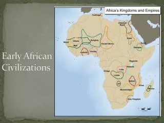
African Civilizations
African Civilizations. African Geography. Africa is the world’s second largest continent by total area. Africa is the world’s second largest continent by population. Africa’s history and cultures usually gets divided into two parts: Saharan Africa Sub-Saharan Africa. A Satellite View.

African Civilizations
E N D
Presentation Transcript
African Geography • Africa is the world’s second largest continent by total area. • Africa is the world’s second largest continent by population. • Africa’s history and cultures usually gets divided into two parts: • Saharan Africa • Sub-Saharan Africa
Africa’s Size 4 6 0 0 M I L E S 5000 MILES • Second largest continent 11,700,000 sq. mi. • 10% of the world’s population. • 2 ½ times the size of the U. S.
The Sahara • Size • Represents, by total area, the largest desert in the world. • As large as the contiguous United States • Climate • Extremely Hot • Highest recorded temperature - 137˚F (Libya) • Extremely Cold • Overnight lows in the 40’s. • Precipitation is minimal, averaging less than 10 inches per year. • However, this process began only a few thousand years ago. • Other conditions include intense sunlight and sandstorms.
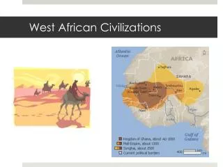
Geographic Terms/Locations Water: Mediterranean Sea, Red Sea, Gulf of Aden, Indian Ocean, Atlantic Ocean, Lake Chad, Lake Albert, Lake Victoria, Lake Tanganyika, Lake Malawi/Nyasa, Nile River, Niger River, Congo River, Limpopo River, Orange River, Zambezi River Land: Atlas Mountains, Great Rift Valley, Mount Kilimanjaro, Libyan Desert, Sahara Desert, Sahel, Namib Desert, Kalahari Desert, Madagascar, Horn of Africa, Cape of Good Hope, Projection Data: Tropic of Cancer, Tropic of Capricorn, Equator, Prime Meridian, legend, compass rose, title
Libyan Desert Sahara Desert Deserts Sahel Namib Desert Kalahari Desert
Mediterranean Sea Bodies Of Water Red Sea NileRiver NigerRiver L. Chad--> Volta River <--Gulf of Aden L. Albert--> Congo River L. Victoria L. Tanganyika-> Indian Ocean Atlantic Ocean Lake Malawi . Zambezi River LimpopoRiver OrangeRiver
People • Desert populations, from the beginning up to today, live near reliable water sources including underground springs and oases • Mostly mildly nomadic, limited agriculture due to scarcity of water.
Sub-Saharan AfricaFeatures • An enormous plateau surrounded by a narrow coastal plain characterizes Sub-Saharan Africa. • The Great Rift Valley dominates the landscape of Eastern Africa. • It cuts through the continent from the Gulf of Suez in the north to Mozambique in the south. • In some places, the walls of the valley are one mile high. • Because of its elevation, parts of East Africa are cool even though they lie along the equator. • Nairobi in the summer remains cooler than Atlanta.
Geographic Zones • Sub-Saharan Africa can be broken into distinct climate zones, beginning with the equator and then progressing out. • Rainforest • Most of equatorial Africa is tropical rain forest. • Average rain fall- 100 inches per year. • Vegetation – rich and diversified.
Geographic Zones • Terms • Deserts, Grasslands, Tropical Forests, Mediterranean, Savannah, Sahara • Tropic of Cancer, Tropic of Capricorn, Equator, Prime Meridian
Grasslands • North and South of the rainforests are “Savannahs” • Regions marked by distinct hot/dry & cool/wet seasons. • Home to most of the wildlife associated with Africa’s plains
Arid Regions • North of the “northern grasslands” lies the semi-arid region known as the Sahel, Arabic for “border”. • Facing “extinction” due to desertification. • Southwest of the southern grasslands lie two more famous African deserts – the Kalahari and the Namib.
Southern Africa • The region enjoys a much milder and consistent climate. • Contains the continent’s most productive farmland.
Mediterranean Sea Atlas Mts. Libyan Desert The Complete Topography Of AFRICA Tropic of Cancer 20° N Sahara Desert Red Sea Sahel NileRiver NigerRiver L. Chad--> Great Rift Valley Horn of Africa <--Gulf of Aden L. Albert--> ΔMt. Kenya Equator 0° Congo River L. Victoria ΔMt. Kilimanjaro L. Tanganyika-> Indian Ocean Atlantic Ocean Zambezi River Lake Malawi . Namib Desert Kalahari Desert LimpopoRiver Tropic of Capricorn20° S OrangeRiver Madagascar Drajensburg Mts. Cape of Good Hope
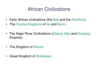
Nubia & Kush • The Nubians established a society along the southern part of the Nile River by 3,000 B.C. • It prospered as a military society that conquered neighboring peoples to the south and east. • Inhabitants traded with and tried to exert pressure on Egypt. • By 2,000 B.C., the civilization evolved into a kingdom known as Kush. • Defeated and conquered by Egypt around 1,500 B.C. • Ruled over by Egypt for more than 500 years. • Developed into a mercantile nation at this point. • Napata and Meroë – two most important trade centers.
Nubia & Kushcontinued • Around 1,000 B.C. the Kushites broke free from Egyptian control as Egypt’s “New Kingdom” began its decline. • In 724 B.C., King Piankhi succeeded in conquering Egypt. • The Kushites ruled over Egypt until the Assyrian invasion in 671 BC • The Kushites concentrated around Meroë, which again became an important trade hub, with the region gaining power as an important production center for iron.
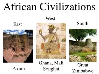
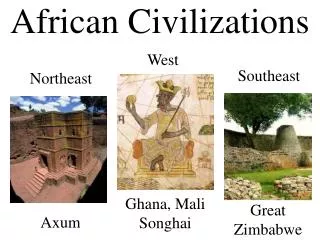
Axum • …or Aksum • Located along the Red Sea in modern-day Ethiopia, Axum was an important trade center, controlling shipping along the Red Sea & Eastern Indian Ocean. • Its contact with Egypt, Arabia, India, and Persia brought an influx of ideas, cultures, and technologies.
Religious Influx • Christianity entered Eastern Africa in the 4th century A.D. • Two shipwrecked Syrians, according to legend, converted King Ezana. • In 330 A.D., Ezana made Christianity the official state religion. • Axumite, later Ethiopian, Christians claim the biblical “Queen of Sheba” as a ancestor, as well as several churches still claiming to be the home of the Ark of the Covenant. • Islam reached Askum in the later part of the 600’s A.D. • While a percentage of the population remained Christian, the majority converted to Islam, laying the foundations for modern-day Ethiopia.
Bantu Migrations • The word “Bantu” refers to a group of people that share a common language ancestor – the Bantu family. • The original culture group originated in Western Africa, perhaps around modern day Cameroon. • Although much studied, historians cannot accurately date the beginnings of the Bantu migration. • Some evidence suggest as early as 1,000 B.C. while other evidence points to a much later date around 500 A.D., or at leas several distinct waves of migration, like the Indo-Europeans and the Asiatic nomads.
Preparation • The initial success of the Bantu came from their ability to farm. • As techniques improved and populations increased, the Bantu would have had to displace the hunter-gatherers that originally inhabited sub-Saharan Africa. • Eventually, overpopulation probably triggered the massed migration of Bantu Speakers from their West African homeland. • Too many difficult geographic barriers, the Sahel and Tropical rainforests, to convert to farmland cost-effectively. • The Bantu also learned how to forge iron. • Its origins and development amongst the Bantu, however, remains the biggest battle between anthropologists/archaeologists who study the Bantu. • (Obviously, the important matter remains that they did develop the technology.)
Migration • As they moved, the Bantu would slowly mix with the original inhabitants of a particular region. • Led to cultural diffusion but also produced distinct difference in cultural features, such as religious beliefs & rituals, language characteristics. • As one would suspect, the geography & climate of a particular area heavily impacted each group’s development. • In many ways, the Bantu migration mirrors that of the Indo-Europeans, who left their ancestral home around the Black Sea and forever changed Eurasian history.
Desertification and Migration packet • This may not apply to your class, so make sure you talk with Mr. Camillo to find out! • Chapter 8 Section 3 (pg 203) – Start to work on your homework in partners or groups of three to read the section and complete the worksheets. • The entire packet will be checked on the HW Check
The hunter-gatherer societies of sub-Saharan Africa, regardless of location, share many of the same cultural traits. • Due, in part, to their contact with & intermingling with the Bantu. • The term “hunter-gatherer” doesn’t rule out light-scale, often seasonal farming practices
Village Government • Small tight-knit communities with clearly defined tribal/family lineages • Work often assigned by age sets, divided in some cases by gender. • Authority often lay in the hands of a single leader. • In some instances, leaders advised by peer groups. • Additionally, many particular issues amongst various groups settled only through the reaching of a consensus amongst the elders.
Family Patterns • The nuclear family acts as the basic organizational unit for these tribes. • Most societies were patrilineal, meaning power and ancestry rested with the father’s family. • Some societies, however, were organized matrilineally. • Great respect, if not too much credence at times, given to one’s lineage. • Common ancestors defined a community’s identity. • “Communing” with ancestors a defining characteristic of these peoples’ religious beliefs. • Beliefs were polytheistic and based on the workings of nature. • Village elders served as religious leaders. • Very often, widowed or unmarried men & women, became the voices of the religion, acting as prophets & soothsayers.
Ghana • A trading empire that existed in W. Africa between 300 & 1200 A.D. • Extended over a territory of more than 100,000 square miles. • The nation prospered from taxes collected on the commodities that moved throughout its territory. • Traded its agricultural products with North Africa. • Oversaw the highly lucrative gold/salt trade. • Gold originated from the southern parts of West Africa. • Salt originating from the Sahel & southern Sahara regions. • Later in its history, the kingdom became heavily influence by Islam. • The Almoravids, a group of North Africa Muslims, attacked at the end of the 11th century, converting much of the population. • Eventually, religious and economic issues split the region into many smaller nations.
Mali • Origins • One the small nations that used to make up Ghana. • Its prosperity came from its agricultural production. • It used to be Ghana’s “breadbasket”. • Expansion • By the late 1200’s, Mali controlled the former territory of Ghana. • Restored and prospered from controlling the traditional trade routes. • Mansa Musa – r. 1312-1332 A.D. • Improved trade and introduced Islam, peacefully, to Mali. • Made a famous pilgrimage to Mecca around the year 1324. • Returned with architects to build mosques and a palace in the capital of Timbuktu. • Decline • After Musa’s death, Mali came under attack from several nations. • It “limped” on until fracturing into smaller nations in the 1500’s.
Songhai • In the late 1400’s, a ruler name Sunni Ali forged the Songhai Empire out of several smaller states. • After his death, Ali’s son inherited the throne. • However, Ali’s son was not Muslim and the people eventually rebelled. • Zenith • Songhai reached its height under a ruler named Askia Muhammad. • Ruled from 1493 to 1528. • Divided Songhai into five provinces, enabling a more efficient government. • Based the kingdom’s laws on strict adherence to the Koran. • Despite power, his own son eventually overthrew Askia. • Collapse • Askia’s downfall led to a series of civil wars. • Weakened, Songhai came under attack from the powerful state of Morocco. • Songhai, which fell by 1600, represents the last of the great sub-Saharan civilizations of West Africa.
Trade Handout • Answers are on the next slide – don’t look!
Trade Routes handouts • Part A • Ghana • Senegal, Gambia, Niger Rivers • Seven • Five • Segu, Jenne, Timbuktu • Part B • Walata • Jenne • Fish, Tusks, Leopard Skins, Tortoise Shell • Camels through the Sahara, Donkey, Head Porterage etc • Important to its survival, long-distance connections, Various styles of transportation
Great Zimbabwe • Zimbabwe, an inland kingdom, arose in southern Africa. • People were descendants of a Bantu group that moved from East Africa, perhaps at the turn of the Common Era. • Explains why many of its cultural traits seem to possess strong connections to other East Africa groups. • Contact with other civilizations before moving away from East Africa might have brought exposure to new technology. • Zimbabwe’s wealth and power, like the East African kingdoms, came from trade. • The region included large deposits of gold and copper. • Reached its height around 1300 A.D.
Architecture • The people of Zimbabwe built massive stone structures, many of which bear similarity in design to the structures of Axum. • The capital city itself represented the southern-most town defended by walls in the Eastern Hemisphere.
Decline • For reasons yet unknown, the kingdom underwent a steep decline beginning around 1500 A.D. • Evidence suggests a series of crippling and unresolved civil wars. • Any potential “rebirth” came to an end as Europeans began to colonize the coastal areas on both sides of the kingdom. • This allowed them to take control of trade, taking away the heart of the old empire’s wealth and power – economic prosperity.
Quiz • Some multiple choice and matching • Short answer • Map
Mediterranean Sea Atlas Mts. Libyan Desert The Complete Topography Of AFRICA Tropic of Cancer 20° N Sahara Desert Red Sea Sahel NileRiver NigerRiver L. Chad--> Great Rift Valley Horn of Africa <--Gulf of Aden L. Albert--> ΔMt. Kenya Equator 0° Congo River L. Victoria ΔMt. Kilimanjaro L. Tanganyika-> Indian Ocean Atlantic Ocean Zambezi River Lake Malawi . Namib Desert Kalahari Desert LimpopoRiver Tropic of Capricorn20° S OrangeRiver Madagascar Drajensburg Mts. Cape of Good Hope