Download
1 / 14
140 likes | 258 Vues
Evaluation of MODIS-Derived Cloud Products Using the ARM SGP Data. Gerald G. Mace and Yuying Zhang University of Utah Steven Platnick and Michael D. King NASA Goddard Space Flight Center Patrick Minnis NASA Langley Research Center Ping Yang Texas A and M.

E N D
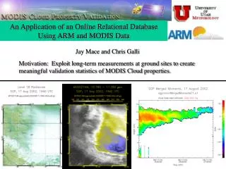
Evaluation of MODIS-Derived Cloud Products Using the ARM SGP Data Gerald G. Mace and Yuying ZhangUniversity of Utah Steven Platnick and Michael D. King NASA Goddard Space Flight Center Patrick Minnis NASA Langley Research Center Ping Yang Texas A and M
MODIS: Moderate Resolution Imaging Spectroradiometer • Currently in orbit on Terra (3/2000) and Aqua (6/2002) • Spectral range (visible, near IR, thermal IR) • Swath – 2300 km • Operational Cloud Property Processing Algorithms • MODIS Atmospheres (Platnick and King) • MODIS-CERES (Minnis)
Cirrus Cloud Property Comparison: Ground-Based Data Cirrus Algorithm • Reflectivity-Radiance • Uses AERI radiance and layer-mean radar Z • Searches for a first order gamma distribution of cloud particles that simultaneously give the correct Z and Emittance. • produces layer mean PSD at ~ 10 minute resolution Millimeter Cloud Radar
Cirrus Cloud Property Comparison: Comparison Technique Bootstrapping Approach Aircraft Ground Satellite aircraft measured IWP (g/m2) RMS: 25% retrieval IWP (g/m2) aircraft measured re (μm) RMS: 20% retrieval re (μm)
Ground-Based Data Source: ARM sites (Atmospheric Radiation Measurement program supported by the U.S. Department of Energy) aircraft ground satellite
COMPARISON TECHNIQUE March 6, 2001 Height-Time cross section of radar reflectivity Wind profiler data observed by the NOAA 404 MHz wind profiler near Lamont Oklahoma Height (km) Height (km) Horizontal Wind Speed (m/s) Horizontal Wind Direction (Degree)
COMPARISON TECHNIQUE Visible image of cirrus observed by MODIS at 1735 UTC in the vicinity of the ARM SGP on 6 March 2001. The SGP central facility is shown with the light green square. The yellow lines show latitude and longitude. SGP selected area
frequency frequency IWP (g/m2) Effective radius (µm) frequency Optical thickness
CLOUD PROPERTIES FOR INDIVIDUAL CASES Comparison between ground-based data and MODIS-CERES Comparison between ground-based data and MOD06
March 22, 2001 MODIS 1.38 micron imagery MMCR: overcast thin cirrus cloud MODIS: 688 pixels detected cirrus in totally 2768 pixels
STATISTICAL COMPARISON Time period: March 2000-July 2001 Satellite data: 648 events when Terra passed near SGP site 100 km x 100 km centered on ARM SGP site totally 895,243 MODIS retrievals Ground-based data: a total of 5772 3-minute averages about 300 hours of cirrus Data distribution: Optical thickness <0.5 0.5~1.0 1.0~1.5 1.5~2.0 2.0~3.0 3.0~4.0 4.0~5.0 MOD06 pixels 811 2036 160,378 93,496 189,675 159,460 142,582 ARM SGP points 3131 1003 522 287 331 205 123
optical thickness: 0-0.5 0.5-1.0 1.0-3.0 3.0-5.0
CONCLUSION • The cirrus cloud properties reported in the MOD06 and MODIS-CERES retrievals agree reasonably well with the aircraft-validated ground-based cirrus cloud properties • The MOD06 retrievals are biased large when optical thickness of cirrus is less than 1.0 • The source of disparity in the spatially-averaged MOD06 results occurred preferentially when the optical thickness of the cirrus retrieved from the radar data was less than about 1.0 • occurrence frequency of optically thin cirrusat80% • a source of uncertainty for MODIS level-3 data FUTURE WORK • Continue to compare for more available cases • Extend the validation work to the other ARM sites