Innovations in 3D Graphics and Terrain Modeling Technology: Overview and Future Prospects
80 likes | 209 Vues
This overview presents the advancements in 3D graphics rendering and terrain modeling technology as developed by Ricardo Veguilla. The project has progressed from initial implementations on SGI systems to cross-platform capabilities with Autotools, modularized code, and enhanced rendering features. Newly added capabilities include a full virtual camera, preliminary lighting support, and the ability to render multiple terrains. Future developments aim to facilitate screen captures, 3D bookmarking, and modular abstraction layers to improve user interaction and performance.

Innovations in 3D Graphics and Terrain Modeling Technology: Overview and Future Prospects
E N D
Presentation Transcript
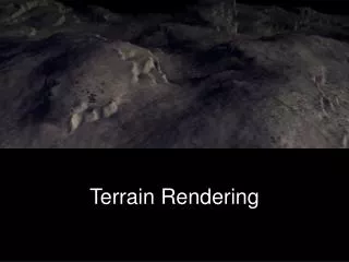
3D Graphics Rendering and Terrain Modeling Technology and Historical Overview By Ricardo Veguilla
Terrain Modeler Project Status
Previously implemented features • Application developed in C and tested exclusively on SGI. • Terrain image loading tested with a 201x201 Matlab generated input file. • Terrain Modeling with OpenGL using points or unshaded polygons. • Fixed camera. • Terrain rotation and scaling. • Limited option for Level-of-detail (LOD) rendering.
Newly Implemented Features • Support for Autotools for cross-platform development (currently tested on SGI and Linux). • Code modularization and refactoring. • Full virtual camera. • Memory Manager subsystem for monitoring memory utilization. • Preliminary Lighting support. • Preliminary support for rendering multiple terrains.
Future Improvements • Full windowed application. • Support for screen captures. • Support for Land-marking (3D bookmarks) • Support for animation scripting and recording. • Support for simultaneous rendering of multiple terrains.
Future Improvements (Cont.) • Restructure code to accommodate three module abstraction layers: • IO Layer – Modules for reading and writing terrain files of different formats. • Sampling Layer – Modules implementing different LOD algorithms with user-selected sampling value. • Rendering Layer – Modules for rendering the terrain using different OpenGL primitives, rendering attributes and vendor-optimized code paths.
Long-term • Porting the project to Jogl: Java OpenGL • http://java.sun.com/products/jfc/tsc/articles/jcanyon/
References: • Wikipidia – The Free Encyclopedia • http://www.wikipedia.org/ • OpenGL - The Industry Standard for High Performance Graphics • http://www.opengl.org/ • Google Image Search • http://images.google.com • Overview of 3D Interactive Graphics • http://www.siggraph.org/project-grants/com97/com97-tut.html • Linux Journal - Industry of Change: Linux Storms Hollywood • http://www.linuxjournal.com/article/5472 • JCanyon - Grand Canyon Demo • http://java.sun.com/products/jfc/tsc/articles/jcanyon/