Download
1 / 39
400 likes | 486 Vues
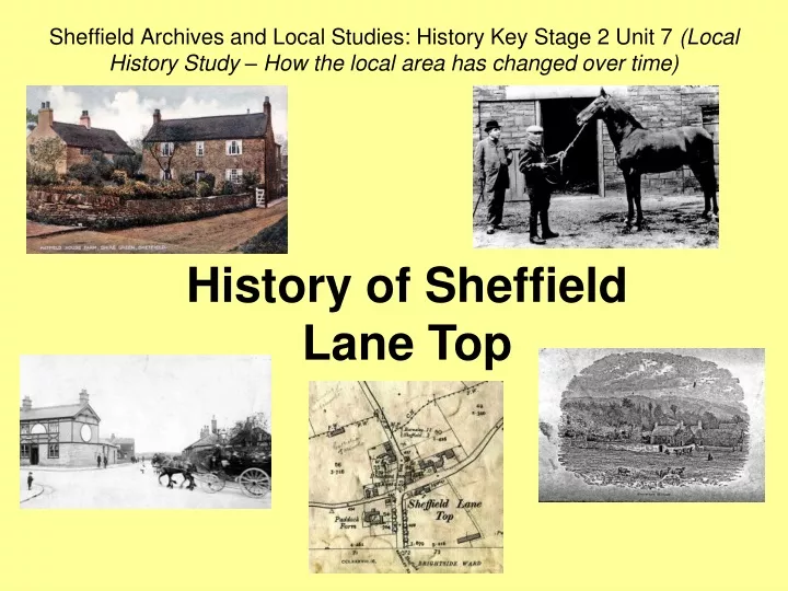
Sheffield Archives and Local Studies: History Key Stage 2 Unit 7 (Local History Study – How the local area has changed over time). History of Sheffield Lane Top. Population of Sheffield over the centuries…. 1086. 150 - 200. 1600. 3,000. 1801. 60,095. 1851. 161,475. 1901. 451,195.

E N D
Sheffield Archives and Local Studies: History Key Stage 2 Unit 7 (Local History Study – How the local area has changed over time) History of Sheffield Lane Top
Population of Sheffield over the centuries… 1086 150 - 200 1600 3,000 1801 60,095 1851 161,475 1901 451,195 2011 552,700
Sheffield Lane Top • Historically part of the parish of Ecclesfield. • People rented land from the Lord of the Manor (at first the Earls of Shrewsbury and later the Dukes of Norfolk). • The population was very small throughout Victorian times. • Lane Top was a tiny hamlet, surrounded by fields, farmland and countryside. • In the 1841 census, the most common jobs in Lane Top area were farmers, agricultural workers and fork makers. Thomas Howard, Earl of Arundel and Duke of Norfolk (1585 - 1646) (Sheffield Local Studies Library Picture Sheffield: s22507)
Satellite view of Sheffield Lane Top today (http://maps.google.co.uk/)
Map of Sheffield Lane Top, 1890 (Sheffield Archives: OS Map 288/12)
The Pheasant Inn at Lane Top can be traced back to c. 1840s. • It still stands today. Pheasant Inn, Sheffield Lane Top (above looking towards Shiregreen, early 1900s; right, 1932) (Sheffield Local Studies Library Picture Sheffield: V00708 and s13346)
1881 Census showing Sheffield Lane Top, Pheasant Inn etc. (www.ancestry.com)
Hatfield House Farm, Hatfield House Lane (Sheffield Local Studies Library Picture Sheffield: s06386) • Hatfield House was actually a small cluster of farm houses in Hatfield House Lane back in Victorian times. • Who lived there back in 1881?
1881 Census showing Sheffield Lane Top, Hatfield House, etc. (www.ancestry.com)
1881 Census showing Sheffield Lane Top, Hadfield House, etc. (www.ancestry.com)
Paddock Farm, Elm Lane (showing horse “the King’s Messenger”), c. 1910 (Sheffield Local Studies Library Picture Sheffield: u00511) Sheffield Street Directory (showing Elm Lane), 1935 (Sheffield Archives: Searchroom Library) • What was the name of the farmer living at Paddock Farm in 1935?
Grand Country Houses in the area • There were several large country houses in the area. • Cliffe House, Elm Lane, was built in 1805. • Who lived there in the 1880s? Cliffe House, Elm Lane (Sheffield Local Studies Library Picture Sheffield: s05981)
1881 Census Showing Cliffe House, Elm Lane (www.ancestry.com)
Sheffield Street Directory (showing Elm Lane), 1935 (Sheffield Archives: Searchroom Library) • By 1934, Cliffe House was no longer a private home. • Can you find out from the street directory what it was used for? • In 1938 a Fire Station was built on its grounds. • The house was demolished c. late 1950s to make way for a new fire station. Cliffe House, Elm Lane (Sheffield Local Studies Library Picture Sheffield: s25119)
Norwood Hall and Grounds, Piper Lane/Longley Lane (Sheffield Local Studies Library Picture Sheffield: s05689) • Norwood Hall was built c. 1713. • Between 1775 and 1915 it became the home of the Wheat family. • What did the Wheat Family do for a living? Sheffield Street Directory (showing Piper Lane), 1906 (Sheffield Archives: Searchroom Library)
Norwood Hall and Grounds (Sheffield Local Studies Library Picture Sheffield: s05690) • Between 1918 and 1959 Norwood Hall became known as “Bishopsholme”. • Who do you think lived there? • Sheffield City Council then used it as a care hostel (for people with disabilities). • Norwood Hall was demolished in 1976. Sheffield Street Directory (showing part of Herries Road), 1935 (Sheffield Archives: Searchroom Library)
Norwood Grange, Longley Lane, was built in 1850s for Thomas Fisher, a partner in the Britannia metal manufacturing company of Shaw and Fisher. • Norwood Grange was bought by Sheffield City Council just before the Second World War. • During the war it was used as a base for the Fire Service and Air Raid Wardens. • In the 1990s the house became Norwood Grange Residential Care Home. Trade advert for Shaw and Fisher, Manufacturers of Britannia Metal (from Sheffield Directory), 1852 (Sheffield Archives: Searchroom Library)
Norwood Grange Sale Catalogues (following death of Henry Fisher), 1888 - 1889 (Sheffield Archives: TC2094)
Sheffield Street Directory (showing Shiregreen), 1906 (Sheffield Archives: Searchroom Library)
The Brushes, Barnsley Road, Firth Park (Sheffield Local Studies Library Picture Sheffield: s05886) • The Brushes was built in 1790 by John Booth, who made his wealth through iron and steel. • Brushes Farm had stood on the site back in the 1640s and its owner, Captain Burley, was executed in 1646 for supporting the King against Parliament in the English Civil War. • In 1920 the building became Firth Park Grammar School. • It was demolished in 2002-2003 and Longley Park Sixth Form College now stands in its place.
Crowder House, Barnsley Road, Longley, was home of the Wilkinson Family from c. 1400 until 1859 when solicitor Bernard Wake purchased it. • It was demolished in 1937 and modern housing now stands in its place (on what is now Crowland Road). • The house had large grounds, some of which became part of Longley Park. Crowder House, Longley (Sheffield Local Studies Library Picture Sheffield: u00471and s05876)
Longley Hall was built c. 1780 for the lawyer Kenyon Parker. • Its lands were later bought for the Workhouse. • The building still stands, owned by a private landlord and run as a care home. Longley Hall, Longley Lane, 1958 (Sheffield Local Studies Library Picture Sheffield: y02136)
Map of Sheffield Lane Top, 1905 (Sheffield Archives: OS Map 288/12)
Shiregreen housing estate under construction, c. 1920s (Sheffield Local Studies Library Picture Sheffield: s12372) • In the 1920s and 1930s, as Sheffield grew rapidly, the area came within the boundary of Sheffield and was used as site for Council housing. • This marked the end of rural life for the area. Longley housing estate, c. 1930 (Sheffield Local Studies Library Picture Sheffield: s12368)
Map of Sheffield Lane Top, 1934 (Sheffield Archives: OS Map 288/12)
Map of Fir Vale area, 1905 (Sheffield Archives: OS Map 288/16)
Sheffield Union Workhouse The poor in Sheffield, 1870 (Sheffield Local Studies Library Picture Sheffield: s03008) • In Victorian times, poor people needing help had to go into the Union Workhouse. • The Sheffield Union Workhouse used to be based in an old cotton mill on Kelham Street, Sheffield (housed up to 600 inmates). • With the Workhouse becoming increasingly overcrowded, in 1881 a new workhouse was built at Fir Vale (housed up to 1,662 inmates).
Why was the workhouse built at Fir Vale? Sheffield Daily Telegraph Newspaper, Wed 5 May 1880 (Sheffield Local Studies Library: Newspaper Collection) Sheffield Union Workhouse, Fir Vale, 1900 (Sheffield Local Studies Library Picture Sheffield: y02028)
What was it like in the Workhouse? • Conditions inside were very harsh. • Families were split up and housed in different parts of the workhouse. • Strict rules to follow. • Inmates were made to work hard doing manual labour such as breaking up stones. Sheffield Union Workhouse, Fir Vale, 1900 (Sheffield Local Studies Library Picture Sheffield: s00405) “Dr Hunt, medical officer to the Workhouse, informed the Sheffield Guardians that the task of the stone breakers should be reduced or their rations increased.” Sheffield Local Register, 16 Sep 1896 (Sheffield Local Studies Library: 942.74 S)
Sheffield Evening Telegraph Newspaper, Wed 6 Jul 1887 (Sheffield Local Studies Library: Newspaper Collection) • According to the newspaper headline about a court case at Sheffield Town Hall, what were two pauper inmates at the workhouse accused of?
Sheffield Union Workhouse Punishment book entries, 1909 (Sheffield Archives: CA510/1)
Sheffield Union: Scattered Homes • In Sheffield, it was eventually decided that poor children should not be made to go into the workhouse. • In 1893, the “scattered homes” system was used where, rather than going into the workhouse, poor children were placed in foster homes ‘scattered’ across Sheffield. • The central headquarters home was at Smilter Lane (now Herries Road). “My visit [to The Scattered Homes] showed evidence of what a sympathetic system and humane instincts could accomplish – a shining contrast to the poor little tired, deserted ones who drag out a melancholy existence in the great workhouses of our land.” Children of the State: Sheffield’s Successful Experiment, 1898 (Sheffield Local Studies Library: 339.1S)
What was name of the foster mother in charge at Sheffield Children’s Homes, headquarters on Herrie Road? Sheffield Street Directory (showing part of Herries Road), 1935 (Sheffield Archives: Searchroom Library) “A typical family’ in Sheffield Union Scattered Homes’ for poor children (149 and 151 Upperthorpe), 1890s (Sheffield Local Studies Library Picture Sheffield: y01176)
Map of Fir Vale area, 1934 (Sheffield Archives: OS Map 288/16)
St Cecilia’s Church, Parson’s Cross, marriage register, 1939 - 1940 (Sheffield Archives: PR45/2/1)
The new housing estates of the 1920s and 1930s soon faced a tough test. • During the Second World War the area was hit by the Sheffield Blitz – when German enemy aircraft attacked the city. • The worst bombing attacks happened in December 1940, killing over 700 people in Sheffield and destroying thousands of homes. • But the Lane Top area withstood the attacks! Sheffield City Council: Emergency Planning Department Second World War bomb damage index card for Herries Road, 1940 - 1941 (Sheffield Archives: X293/1/4)
Sheffield Civil Defence Department list of people killed in the Sheffield Blitz, 1940 - 1941 (Sheffield Archives: 2010/155)
Recap… • What did people do for jobs back in the area 100 years ago or more? • What about if you lived in one of the big grand Victorian houses? • What happened to very poor people who couldn’t look after themselves? • What tough test did the new housing estates of the 1920s and 1930sface soon after being built?
Sheffield Archives and Local Studies • If you would prefer to use this presentation as the basis for a class visit to Archives and Local Studies or in a visit by us to your class please contact us. Students will have the opportunity to see and touch the original items. • We offer: • Access to original primary source material from Tudor times through to the 21st century. • Class visits to the Central Library and to Sheffield Archives. • Visits to schools to deliver classroom sessions. • Introductory sessions for teaching staff. • Online PowerPoint lesson resources. • Focus Packs of colour facsimiles linked to the National Curriculum. www.sheffield.gov.uk/archives