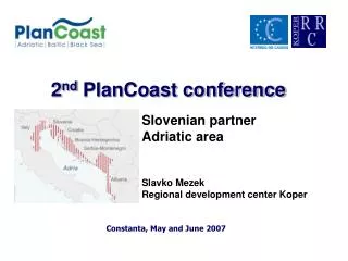
2 nd PlanCoast conference
The Slovenian coast, 46 km long and divided into Koper, Izola, and Piran, faces significant challenges in regional planning and development. This project focuses on integrated spatial planning, addressing the current status of sea uses, creating a GIS database for a cross-border sea-use plan for Trieste Bay, and preparing new municipal spatial plans. Key findings include the instability of the planning system, insufficient public involvement, and pressures from tourism and infrastructure development on the coastal zone. Sustainable solutions and better management practices are essential for protecting natural and cultural heritage.

2 nd PlanCoast conference
E N D
Presentation Transcript
2nd PlanCoast conference Slovenian partner Adriatic area Slavko Mezek Regional development center Koper Constanta, May and June 2007
SLOVENIAN COAST • The Sloveniancoast is only 46 km long (one thousandth of the entire Mediterranean) • Thewhole coastal area is divided into three municipalities, namely: • Koper • Izola and • Piran
RRC KOPER: ROLE IN THE PROJECT WP1: Assessment of current status WP2: Creation of a GIS database on relevant Slovenian data as a basis for a cross-border (Italy/Slovenia/Croatia) sea-use-plan of Trieste Bay WP3: Compile data on current sea uses in Slovenian 12 sm zone of Trieste Bay and develop an integrated, single map of current sea uses WP4:Prepare expert groundwork for new municipal spatial plans
Evolution of spatial planning in the country Planning agencies (national, local level) Planning framework Involvement of public Development control Problem: Instablity of the system, focus on the system, not in the content, Problem: lack of regional/provincial level Problem: weak supporting “soft” instruments (incentives, information management) Problem: involvment too formal, weak participation of general public, conflicts, weak resolution management, Problem: weak planning controll Findings – national reportSpatial planning system in the country
urban, countryside and transportplanning environmental protection and planning conservation of nature and cultural heritage coastal zone planning maritime spatial planning Integration transport/ spatial planning Dispersed settlement structure/ costs of infrastructure lack of management of protected areas, no specific arrangements existing, non existing maritime spatial planning, Findings – national report Spatial planning system in the country
Findings – national reportSpecifities of spatial planning incoastal zones • Tourism: pressures on the coastal strip; • investments ( hotels, marinas) are planned almost exclusively in the coastal strip,
Findings – national reportSpecifities of spatial planning incoastal zones • Transport: development of Pot of Koper • Transport: modal split/sustainable mobility, congestion,
Findings – national reportSpecifities of spatial planning incoastal zones • Environmental infrastructure: • communal waste, • waste water drainage and treatment, • water supply,
Findings – national reportSpecifities of spatial planning incoastal zones • Nature, biodiversity: spatial conflicts, management, threats/environmental pressures, • Cultural heritage protection and management ,
Findings – national reportSpecifities of spatial planning incoastal zones • Litoralistation, urban sprawl, real estate market,
Findings – national reportSpatial planning incoastal zone • Planning in coastal zones • Existing plans based on spatial plans, prepared in late 80-ies; several times ammended, • ammendments do not assure integrated approach-new plans needed; • lack of clear vision and goals, related to sustainable development, • non existent sustainable mobility schemes, which fosters urban sprawl,
Current sea uses • Current uses identified • Legal basis and regimes identified
Spatial planning • Compiled existing spatial plans, detailed municipal spatial plans;
THANK YOU FOR YOUR ATTENTION Slavko Mezek Regional Development centre of Koper Zupanciceva 18, 6000 Koper, Slovenia Phone: +386 5 66 37 580 Fax: +386 5 66 37 581 E-mail: info@rrc-kp.si Internet page: www.rrc-kp.si