Download
1 / 1
10 likes | 132 Vues
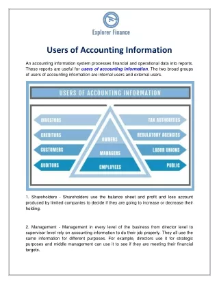
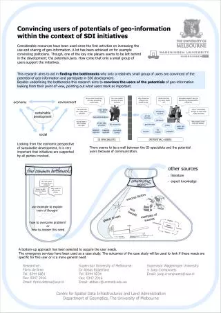
source of fire. source of fire. land administrations. geological surveys. private data providers. value added resellers. cadastral agencies. mapping agencies. RS companies. Our new system will solve all your problems. Why invest? It will only cost money. SDI. mitigation.

E N D
source of fire source of fire land administrations geologicalsurveys private dataproviders value addedresellers cadastral agencies mappingagencies RS companies Our new system will solve all your problems Why invest? It will only cost money. SDI mitigation disaster management preparedness recovery response disaster Investments towards sustainable system time Investments to get the old situation back; no real development With SDI Without SDI Convincing users of potentials of geo-information within the context of SDI initiatives Considerable resources have been used since the first activities on increasing the use and sharing of geo-information. A lot has been achieved on for example convincing politicians. Though, one of the key role players seems to be left behind in the development; the potential users. How come that only a small group of users support the initiatives. This research aims to aid in findingthebottlenecks why only a relatively small group of users are convinced of the potential of geo-information and participate in SDI development. Besides underlining the bottlenecks this research aims to convince the users of the potentials of geo-information looking from their point of view, pointing out what users mark as important. Reorganize again?! We just had two big reorganizations behind us! No you don’t want that, we have something much better Our new system will solve all your problems Why should we change? Our system works. What is an SDI, I’ve never heard of it economy environment The world will be a safer place with SDI Yes, it is important, though we have other higher priorities emergencyservices sustainable development privateinstitutes insurance You will earn a lot of money from SDI Why invest? It will only cost money. governments police water gastelecom firebrigade tourism transport social GI SPECIALISTS (POTENTIAL) USERS Looking from the economic perspective of sustainable development, it is very important that initiatives are supported by all parties involved. There seems to be a wall between the GI-specialists and the potential users because of communication. • other sources • literature • expert knowledge What is an SDI, I’ve never heard of it success factors use example to explain train of thought cost benefit examples of success global drivers how to overcome problem? or how to answer this need A bottom-up approach has been selected to acquire the user needs. The emergency services have been used as a case study. The outcomes of the case study will be used to look if these needs are specific for this user or is a more general need. Researcher: Floris de Bree Tel: 8344 6881 Fax: 9347 2916 Email: floris.debree@wur.nl Supervisor University of Melbourne: Dr Abbas Rajabifard Tel: 8344 0234 Fax: 9347 2916 Email: abbas.r@unimelb.edu.au Supervisor Wageningen University: Ir Joep Crompvoets Email: joep.crompvoets@wur.nl Centre for Spatial Data Infrastructures and Land Administration Department of Geomatics, The University of Melbourne