Design with two heads No catching losses due to wind effect, no bucket or vessel Wide intensity range 0,001 to 1200 mm/h
210 likes | 628 Vues
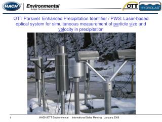
OTT Parsivel Enhanced Precipitation Identifier / PWS: Laser-based optical system for simultaneous measurement of pa rticle si ze and vel ocity in precipitation. OTT Parsivel ®. Design with two heads No catching losses due to wind effect, no bucket or vessel

Design with two heads No catching losses due to wind effect, no bucket or vessel Wide intensity range 0,001 to 1200 mm/h
E N D
Presentation Transcript
OTT Parsivel Enhanced Precipitation Identifier / PWS: Laser-based optical system for simultaneous measurement of particle size and velocity in precipitation
OTT Parsivel® • Design with two heads • No catching losses due to wind effect, no bucket or vessel • Wide intensity range 0,001 to 1200 mm/h • Velocity: 0,2 to 20 m/s • Sizes: 0,2 to 25 mm • Reports according WMO codes
OTT Parsivel® - The Principle The sensor's transmitter unit generates a flat, horizontal beam of visible red laser light, which the receiver unit converts into an electric signal. The absolute amplitude can even change, only dynamic radiometric signal changes gets considered whenever a particle falls through the beam anywhere within the measurement area. The ratio of dimming is direct related to the particles size, and in correlation with duration of the extinction, the fall velocity can be derived.
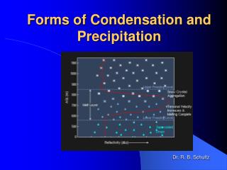
OTT Parsivel® - Type Of Precipitation: Rain • Accumulated particles in 60 second interval • Drop speed like Gunn-Kinzer distribution (dashed line) • Rain because large number of drops on the Gunn-Kinzer curve • Derivation to water equivalent • Drops with different shapes relating to sizes and speed • Distinguish of different types of liquid precipitation: drizzle, rain, mixed form in light moderate and heavy classes
OTT Parsivel®- Type Of Precipitation: Snow • Accumulated particles in 60 second interval • Particle speed like Locatelli and Hobbs distribution (dotted line) • Particle speed is very slow • Snow because large slow particle, on or near by the Locatelli and Hobbs curve • Distinguish of solid precipitation: snow, grain, hail and mixed form in light, moderate and heavy classes
Drop distribution: 32 classes of size and speed Intensity and accumulation of precipitation WMO reports: WaWa, WW, Metar, Speci, NWS Visibility in precipitation Radar reflectivity Laser energy Number of particles Measuring interval Housekeeping data: heater power, supply voltage, sensor status, temperature OTT Parsivel® - Operating Software
Features and high lights • Fully configurable data string in sequence and content, fexibility for wide range of datalogger market • Software controlled heating device for mains ( 50 W ) and medium solar power applications ( 2 W ) • Configuration and expert spectrum evaluation SW ASDO • Calibrated precipitation parameter, optical precipitation sensor for unattended operation • Automatic self adjustment at no precipitation event concerning temperature, laser alteration and condamination of optics • Sensor for unattended operation, no further calibration or maintenance required at the sites.
Patented extinction method for simultaneous measurement of particles size and velocity Only one version and fully configurable for all applications Multipurpose instrument for PWS, optical precipitation sensor, spectrum distribution and energy, radar reflectivity and visibility in precipitation (MOR) Multipurpose interfaces for RS 485, RS 422, SDI-12, Digital Output for state of precipitation and pulse related to 0,1mm Parallel operation of ASDO (PC-Monitoring and logging) and datalogger with SDI-12 Features and high lights
Market and customers Present Weather Sensor Enhanced Precipitation Identifier - Meteorological Services - Avalanche Warning institutes - ASOS Systems Airports - Flood warning Systems - Water Resources and Energy Precipitation intensity - Hydrological Services - Water Boards - Flood Warning - Water Resources and Energy - Avalanche Warning Institute PWS PI V PD MZ Precipitation distribution and precipitation energy - Universities - Soil Research Institutes - Avalanche Warning Institutes Visibility Traffic Monitoring: - Road Weather Information System - Harbour Monitoring System • Heliport Monitoring System - Naval Market/Navigation Supplier Z/R-calculation - Weather Radar Supplier - Weather Radar Network
Calibration and Test Bench • Calibration in production cell in full automation procedure • Simulated reference particles in size and velocity by rotating precision disk • Download of data field for laser related tolerances and coefficients, depending on size variation • Factory Acceptance Test Protocol as individual test record • Calibration and test device for weather Services concerning yearly quality inspection
Satellite Transmission GOES / Meteosat Satellite Data Collection Platforms Receiving Stations
User Interfaces 12 VDC Power Supply RS 232 and open protocol GPS Antenna, exact time and location Antenna clutch for Yagi Power safe mode LED indication Easy Use SW for configuration, test and antenna alignment
HDR transmission modes • Certified transmission formats • Meteosat (incl. MSG) • Self-Timed Mode, Alarm Mode • GOES 100, 300 bps; • Self-Timed Reporting Mode, • Random Reporting Mode • International channels (IDC)
Direct Readout Ground Station DSR II Antenna 5 m Dish ~ 1.6 GHz Down converter ~ 150 MHz Private Ethernet ~ 2.5 Mbyte/sec TCP/IP on Ethernet HYDRAS 3 + Communication manager DCP Acquisition
Meteosat footprint 2nd satellite at 63°E available!!
GOES Footprint GOES 10 (WEST) GOES 12 (EAST)