1. INTRODUCTION
A. A. B. B. HARBOUR HYDRODYNAMIC MODELLING WITH ROMS: BILBAO CASE STUDY Luis Ferrer 1 , Manel Grifoll 1 , Manuel González 1 , Manuel Espino 2 1 Unidad de Investigación Marina, AZTI-Tecnalia, Herrera Kaia – Portu aldea z/g, 20110, Pasaia – Gipuzkoa, Spain

1. INTRODUCTION
E N D
Presentation Transcript
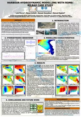
A A B B HARBOUR HYDRODYNAMIC MODELLING WITH ROMS: BILBAO CASE STUDY Luis Ferrer1, Manel Grifoll1, Manuel González1, Manuel Espino2 1Unidad de Investigación Marina, AZTI-Tecnalia, Herrera Kaia – Portu aldea z/g, 20110, Pasaia – Gipuzkoa, Spain 2Laboratori d’Enginyeria Marítima (LIM), Universitat Politènica de Catalunya, Jordi Girona s/n, 08023, Barcelona, Spain ABSTRACT 1. INTRODUCTION The Regional Ocean Modelling System (ROMS) has been tested in Bilbao harbour located in the east corner of the Bay of Biscay, northern Spain. In this study, the inner harbour hydrodynamics, as observed through oceanographic measurements, has been numerically replicated. Measurements show seasonal differences which have been used to define the climatology input to the modelling process. Moreover, daily NCEP reanalysis data have been used as atmospheric forcing. The numerical results are in good agreement with the hydrodynamic measurements showing the suitability of ROMS in the study of coastal hydrodynamics with a high resolution. Key Words: Coastal Modelling, Harbour Hydrodynamics, ROMS, Seasonal Differences. The reclamation of large harbour platforms for industrial, economic and commercial activities, in addition to nautical and recreational purposes, implies changes in their hydrodynamic behaviour and strongly influences their water quality. This is the case of the Bilbao harbour, located in the inner part of the Nervion river estuary (Figure 1), which has been growing progressively to the outer estuarine and open sea areas, becoming one of the largest harbours of the continent (Figure 2). The history of the harbour might well be told as a continuous voyage sailing out to the sea. Figure 1. Aerial photography of Nervion estuary Figure 2. Bilbao harbour: past and present. 2. HYDRODYNAMIC BEHAVIOUR 3. MODELLING CHARACTERISTICS The hydrodynamic behaviour of Bilbao harbour is characterised by the tidal dynamics, the baroclinic component observed in the CTD vertical profiles, and the wind stresses that play an important role in the currents in the outer zone of the harbour (Figure 3). Tides are defined as low and high mesotidal during neap and spring tides respectively (Figure 4). The vertical density structure presents two main characteristic situations (Figure 5): a) during winter, a homogeneous density structure dominates; b) whilst during summer, a considerable vertical density gradient is observed. The model configuration has a mean horizontal resolution of approx. 32 m and 5 vertical sigma levels in depth (Figure 6). Initial and boundary temperature and salinity conditions were derived from seasonal hydrographical observations measured inside the harbour. The atmospheric forcing was provided by daily NCEP reanalysis data: 10m winds, surface air pressure, 2m temperature and relative humidity, and net shortwave and downward longwave radiations. Air-sea heat and momentum fluxes were calculated by the bulk formulae of Fairall et al. (2003). The inflow of the Nervion river was specified as monthly climatologic values.Tidal forcing was included in the simulation according to the data from the OSU Topex/Poseidon Global Inverse Solution version 5.0 (TPXO.5). Figure 4. Sea-level measurements recorded at Bilbao harbour Figure 6. Harbour bathymetry. The eight primary harmonic constituents (M2, S2, N2, K2, K1, O1, P1, Q1) were introduced in ROMS through the open boundaries using the Flather condition (Marchesiello et al., 2001). In forecast mode, the model output data were automatically acquired from the hourly history fields and daily averaged fields. Figure 5. Density and temperature profiles during winter and summer (2004-2005). Figure 3. Surface currents (with and without tides) inside the Bilbao harbour 4. RESULTS The hydrodynamics of Bilbao harbour has been simulated with ROMS (Shchepetkin and McWilliams, 2005) for two weeks during the winter and summer of 2005. Results obtained for the 3rd January and the 4th July are shown on Figures 7 and 8. Comparison between the numerical results and the hydrodynamic data from surveys, shows that the model reproduces well, (i) the temperature values measured during the winter and summer in the harbour domain (Figure 7.2 and 8.2); (ii) the presence of the stratified vertical structure during summer (Figure 8.6) and; (iii) a well-mixed structure during the winter (Figure 7.6). The vertical structure of the water column during summer is associated to the increase of the heat transfer at the sea surface and the consequent rising of the water temperature. This process in sheltered zones tends to produce the presence of a thermocline in the vertical profile (Bowden, 1983). The salinity field structure at sea surface decreases in the inner harbour zone due to the freshwater discharge of the Nervion river, especially in the winter season. The current fields are obtained by averaging daily the hourly history velocity fields (Figures 7.1 and 7.3 during winter and Figures 8.1 and 8.3 during summer). The averaged current fields are characterised by a complex flow in winter due to the strong winds in the interest area and the frequent freshwater discharge from the river, in addition to the irregular topography of the harbour. In summer conditions, the current fields are smoother than in winter, due to the weaker winds and the decrease in the river runoff. Figure 8.1. Eastward averaged velocity (m/s). Figure 8.2. Sea surface temperature (ºC). Figure 7.1. Eastward averaged velocity (m/s). Figure 7.2. Sea surface temperature (ºC). Figure 7.3. Northward averaged velocity (m/s). Figure 7.4. Sea surface salinity (PSU). Figure 8.3. Northward averaged velocity (m/s). Figure 8.4. Sea surface salinity (PSU). Figure 7.5. Northward averaged velocity A-B. Figure 7.6. Temperature A-B. Figure 8.5. Northward averaged velocity A-B. Figure 8.6. Temperature A-B. Figure 7. Numerical results during 3rd January 2005. Figure 8. Numerical results during 4th July 2005. 5. CONCLUSIONS AND FUTURE WORK BIBLIOGRAPHY Bowden, K.F., 1983. Physical Oceanography of Coastal Waters. John Wiley & Sons. Baffins Lane. West Sussex. England. 301 p. Fairall, C.W., Bradley, E.F., Hare, J.E., Grachev, A.A., Edson, J.B., 2003. Bulk parameterization of air-sea fluxes: updates and verification for the COARE algorithm. J. Climate, 16 (4), 571-591. Marchesiello, P., McWilliams, J.C., Shchepetkin, A., 2003. Equilibrium structure and dynamics of the California current system. J. Phys. Oceanogr., 33, 753-783. Shchepetkin, A.F., McWilliams, J.C., 2005. The regional oceanic modeling system (ROMS): a split-explicit, free-surface, topography-following-coordinate oceanic model. Ocean Model., 9, 347-404. This work shows the suitability of the ROMS numerical code for small scale areas. Using specific monthly climatology information for the harbour and forcing input provided by the daily NCEP reanalysis data, the model reproduces reasonably well the hydrodynamic behaviour inside the harbour and the seasonal differences observed in the vertical density profiles. These results are considered as a starting point for the implementation of an operational system in the harbour; i.e. a tool for the environmental management of the water quality (Figure 9). As to the hydrodynamic modelling, further work in model calibration, verification and data assimilation would be necessary to achieve this goal. Real time field data Hydrodynamic modelling Water Quality Environment System (operational mode) Transport evaluation ACKNOWLEDGEMENTS Risk analysis This work has been carried out with partial financial support from different sources of the Basque Government (Departamento de Agricultura, Pesca y Alimentación; Departamento de Medio Ambiente y Ordenación del Territorio; Departamento de Industria, Comercio y Turismo and Departamento de Educación, Universidades e Investigación), and the Ministerio de Ciencia y Tecnología (Spain). The authors acknowledge the NCEP reanalysis data provided by the NOAA/OAR/ESRL PSD (www.cdc.noaa.gov). In addition, thanks to the ESEOO project (www.eseoo.org) for providing a research reference in Operational Oceanography and the Bilbao Harbour Authority for the logistical support (www.bilbaoport.es). USERS Real time forecasts Figure 9. Harbour water quality management system.