Download
1 / 3
0 likes | 1 Vues
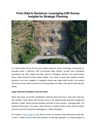
In a world where timing and accuracy shape outcomes, drone technology is becoming an everyday asset in planning. UAV (Unmanned Aerial Vehicle) surveys once considered specialized now offer insights that help councils, developers, farmers, and environmental teams make informed choices without delays. The clarity of aerial data supports smarter decisions, from how a paddock is irrigated to where new roads might be laid. Letu2019s explore how these surveys offer more than just stunning views from above, they deliver data that gets results. Visit https://lpdsurveys.com.au/ for more details.

E N D
From Data to Decisions: Leveraging UAV Survey Insights for Strategic Planning In a world where timing and accuracy shape outcomes, drone technology is becoming an everyday asset in planning. UAV (Unmanned Aerial Vehicle) surveys once considered specialized now offer insights that help councils, developers, farmers, and environmental teams make informed choices without delays. The clarity of aerial data supports smarter decisions, from how a paddock is irrigated to where new roads might be laid. Let’s explore how these surveys offer more than just stunning views from above, they deliver data that gets results. Urban Planning That Moves with the Times When cities grow, so do their complexities. Planners need more than a map, they need real- time visibility. That’s where UAV surveys come in. By capturing high-resolution images and elevation models, drones provide detailed overviews of land contours, drainage paths, and existing infrastructure. This allows urban planners to assess where to build, what to protect, and how to prevent issues like waterlogging or traffic bottlenecks. For instance, a site survey in Perth done by drone can quickly reveal flood-prone areas after a storm. It helps councils make fast decisions on drainage upgrades or zoning changes far
quicker than traditional ground-based methods. What used to take weeks now happens in days, with more accuracy. Precision Matters in Agriculture In farming, small adjustments often make a big difference. UAV survey data is helping growers pinpoint which areas of a field are underperforming. By analysing plant health from aerial imagery, farmers can change how they irrigate or apply nutrients, reducing waste and improving yields. UAV data also allows seasonal comparisons. Farmers can compare current crop conditions with previous years to predict outcomes and adjust sowing strategies. With UAV mapping, it's easier to manage large properties and respond early to signs of stress before they become problems. It's not just about data; it’s about better timing. Resource Management with a Broader View Managing land, water, and natural assets requires a bird’s-eye perspective literally. Drone surveys provide 3D terrain models, helping resource managers monitor erosion, vegetation changes, or illegal activities such as dumping or land clearing. This data supports compliance, planning, and even funding applications. For developers or environmental teams looking for a site surveyor near me, UAVs reduce the need for constant site visits. Data is collected faster, and remote areas are more accessible. This is especially helpful in conservation projects, where land changes must be tracked over time without disturbing the site. What Makes UAV Surveys a Reliable Option? Aerial surveys by drone aren’t just fast;they’re incredibly versatile. They support everything from design approvals to environmental audits. Since the data can be shared digitally, teams across departments or regions can stay aligned without needing to be physically present on- site. Accuracy is another key benefit. Drone mapping reduces human error and offers consistent repeatability, which is essential when comparing data over time. Final Thoughts
Planning, whether it’s for a new suburb, an orchard, or a national park, depends on reliable information. UAV surveys are making that information easier to access, quicker to analyse, and far more detailed than traditional methods allow. As more teams adopt drone data for decision-making, they’re finding it easier to stay ahead of problems and make choices backed by facts, not guesswork. Aerial surveys don’t just collect data; they support action. The author is an experienced surveyor who offers expert insights on UAV surveys and their impact on strategic planning decisions. Visit https://lpdsurveys.com.au/ for more details.