Download
1 / 20
200 likes | 319 Vues
Explore the importance of Sea Surface Temperature (SST) monitoring through GHRSST project, its data flow, international landscape involvement, and planned future initiatives. Discover why SST matters in climate change, oceanography, ecosystem management, and forecasting. Learn about GHRSST's role in merging various satellite data sources for accurate SST measurements and its global impact.

E N D
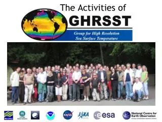
The Activities of Andrea Kaiser-Weiss GHRSST Project Officer, based at NCEO, University of Reading, UK
Outline • Why Sea Surface Temperature (SST) and why GHRSST (Group for High Resolution SST) • GHRSST Data Flow • GHRSST in the International Landscape • Planned Future • Summary
Why SST : Storms Kerry A. Emanuel (April 2010)
Why SST: Rainfall variability Rainfall EOF’s Long-term change Correlated SST Giannini, Biasutti, Held and Sobel, Climatic Change, 2008
Why: Climate change 1961-1990 average: 13.97 C Source : BoM graphics from HadCRUT3v data Heat content (1022 joules) Global ocean heat content in the upper 700 m. Climate Change Indicators in the United States, p 36, EPA 430-R-10-007, April 2010.
Motivation : Oceanography Surface Trend (ºC/10 yrs) 1950-2010 Source : BoM graphics from HadCRUT3v data • SST related science in Oceanography : • air/sea flux • currents, eddies, fronts • AMO • trends in all of the above
Why SST ? • Ocean modelling and forecasting • NWP (hurricanes, seasonal-interannual rainfall variability) • Climate variability and change • Ecosystems (habitats, aquaculture) • Fisheries • Navy acoustic signal processing
Why GHRSST ? MTSAT-1R Imager AQUA AMSR-E MODIS MSG-SEVIRI Imager TRMM TMI GOES Imager METOP POES AVHRR ENVISAT AATSR Credit: C. Gentemann
Why GHRSST ? GHRSST IX (2008): “To develop and nurture cooperation and progress at the world scale in the subject area of satellite Sea Surface Temperature”
GHRSST Builds on EO complementarities… DataMerging • Polar infrared has high accuracy & spatial resolution • Geostationary infrared has high temporal resolution • Microwave Polar orbiting has all-weather capability • In situ data provide reality in all weather conditions
Definitions of SST SST – SST10m (K) 0 0.5 1.0 1.5 2.0 2.5 3.0 10mm 1 mm Daytime, light winds SSTint interface sea surface temperature 1 m Night-time, or strong winds SSTskin sea surface skin temperature Depth SSTsubskin sea surface subskin temperature SSTfnd sea surface foundation temperature SSTdepth sea water temperature at depth z, e.g.,SST2m 10 m
Combining satellite data: MyOcean L3 (Europe)
US: for example MUR analysis by Mike Chin at JPL
User tools and Services • NAIAD and dataminer • IFREMER and JPL • SQUAM • GMPE • HRDDS • WMS • G1 OurOcean • DataCasting
Estimation Methods EARWiG Diurnal Variability DV-WG Lake Surface Water Temp. LSWT-WG Data Assembly and Systems DAS-TAG High Latitude HL-TAG Applications and User Services AUS-TAG Inter-comparisons IC-TAG Reanalysis RAN-TAG GHRSST Organisation CEOS-VC International Stakeholder Advisory Council GPO : GHRSST International Project Office International GHRSST Science Team SSES and Validation STVAL-TAG Rescue & Reprocessing Historical AVHRR Archives R2HA2-WG User Requirements for high resolution Sea Surface Temperature data products and services from operational, scientific, and climate communities.
3. GHRSST in the international landscape GHRSST = well linked to the national and international space agencies, Met-offices, and major research institutes (e.g. Navoceano, NOAA) GHRSST interaction with NASA SST Science Team, ESA CCI, MyOcean, Australia, Japan, New: South Korea, Brazil, Canada, China, India . Links to CEOS, GCOS, WMO, JCOMM, WCRP, OceanView, ET-OOFS, …
Planned Future for GHRSST: CEOS SST Virtual Constellation (SST-VC)
Summary • GHRSST mission: to provide SST to operational users and a to a massive science community • GHRSST priority research: uncertainty estimates, Sensor Specific Error Statistics • Research issues: variability in the upper ten metres cloud detection, long-term stability • Users: which SST should they be provided with ? reliable GHRSST operational mature
GHRSST XII Science Team meeting 2011 Edinburgh, Scotland, 27 June - 01 July Special emphasis is on facilitating the exchange between data users and producers. Please indicate your interest by sending an email to ghrsst-edinburgh2011@reading.ac.uk