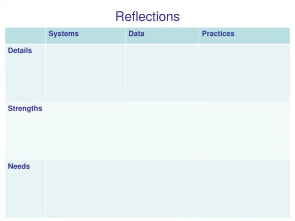
Amateur Hydrographer's Reflections on Soundings in Uncharted Waters
Join amateur hydrographer Andrew Boon on a journey through Port Davey and Bathurst Harbour as he reflects on the importance of accurate soundings in unsurveyed areas. Discover his adventures with sounders and GPS devices, and learn how he navigates uncharted waters with a portable rig designed for dinghies. Explore the process of depth recording, understanding published depths, and the future procedure for charting unknown territories. Follow his method of recording soundings, determining tidal variations, and transferring data onto charts for a comprehensive cruising guide. Embark on a nautical exploration guided by an enthusiast's passion for hydrography.

Amateur Hydrographer's Reflections on Soundings in Uncharted Waters
E N D
Presentation Transcript
An amateur hydrographer in Port Davey/Bathurst Harbour Sounding Reflections Cruising Yacht Club of Tasmania By Andrew Boon aboon@bigpond.com 2 Nov 2010
Why do I do it?? • Many good anchorages are in unsurveyed or inadequately surveyed areas • I hit an uncharted rock • Reflections had a sounder and GPS receiver which can easily log depths • West Marine had a handheld sounder on special • It becomes an addiction
Reflections’ Sounders • Lead line, marker every metre • Fixed sounder, Raymarine ST40, offset to read depth below keel, set to read zero when touching bottom • Handheld, built-in display • Portable rig designed to be used in dinghy, made up of CruzPro ‘intelligent sensor’, GPS60 handheld GPS receiver and battery.
Lead line The ultimate technology! The weight should have a depression in the bottom filled with wax to collect a sample of the sea floor (sand, mud, etc).
Handheld sounder • Press button, hold end in water facing downwards, read depth. • Switches off automatically when not in water. • Resolution 0.1 metre.
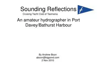
Chris is holding the handheld sounder and helming, I am entering waypoints on the handheld GPS (Mar 2008)
Portable sounder for dinghy Battery cabling NMEA data CruzPro ATT120A Garmin GPS60
Prototype portable sounder With this arrangement, the pole had to be held in place by hand when travelling at 2 knots or more. The Mk 2 version will have a more rigid frame to hold the sensor to the transom of the dinghy. Depth readings appeared to be consistent for speeds up to at least 6 knots. Junction box, switch, fuse GPS Clamp to fasten to transom Battery CruzPro sensor
What determines the ‘published’ depth? • The value displayed on your sounder • The depth of the transducer • Offsets (eg to convert to depth below keel) • The time of the reading – affects tidal height. Variation due to atmospheric pressure (~10 mm/hPa), wind, storm surges, diurnal and seasonal variations, etc. • The accuracy (error) of the sounder • The variation of depth in the near vicinity – significant changes over the error range of GPS
2008 attempt: Kings Point This is the first ‘unsurveyed’ area we looked at, recording the 2 metre depths. Later soundings used 3 m as it is considered a more useful minimum depth for keelboats.
Parker Bay 3 m contour Using handheld sounder, row until sounder reads ‘3.0’ then press ‘Mark’ on GPS to record waypoint (March 2008).
Iola Bay 3 m contour We (Chris Creese and Andrew Boon) were attempting to find the reported rock in Iola Bay.
Casilda Cove 3 m ‘track’ In this one, we attempted to ‘follow’ the 3 m depth contour by watching the handheld sounder display and recording the GPS Track (rather than recording Waypoints). (The north-most end is the rock at the entrance to the anchorage.)
2010 Method • Record depth every 10 seconds. At 2 kn, sample interval is 10 m. • Use lower speed if more depths desired, eg if depth changes rapidly, to identify rocks etc.
Melaleuca Inlet Soundings taken with Reflections’ fixed sounder, logged as part of GPS60 Track, edited in OziExplorer. Soundings are legible on the PDF image. Melaleuca Inlet depths 3_2010 Melaleuca Lagoon depths
What is the best format? • For a cruising guide, I think the 3 m contour is the best option. • But you would never go near Frog’s Hollow! • It is ‘safe’, ie even with a 1 m error, most keelboats would still be OK. • And it leaves the shallower areas undocumented, for intrepid explorers in dinghies!
Future Procedure • Estimate the height of the tide • Sail and log the 2 m contour (actually 2 + height of tide) • Sail and log a grid at 100 m spacing, 10 second samples using the 2 m contour as a boundary • Mark a waypoint at isolated rocks or shallows • Log the tidal variation at anchor over at least 12 hours, to establish a datum • Use a bathiscope to see what is on the bottom
Getting the numbers onto a chart • Transfer track log from GPS to MapSource • Save track to a text file • Import into Excel, apply offset, tidal and atmospheric corrections and massage into OziExplorer waypoint format • Save as a .wpt file • Open relevant map in OziExplorer and load waypoints (.wpt file) • Thin out the data for best presentation