Download
1 / 14
150 likes | 359 Vues
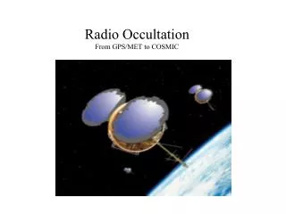
Radio Occultation From GPS/MET to COSMIC. Background: Global Positioning System (GPS) Satellites Low-Earth Orbit ( LEO) Satellites. A GPS receiver in LEO can track GPS radio signals that are refracted in the atmosphere. GPS Satellite. LEO Orbit.

E N D
Radio Occultation From GPS/MET to COSMIC
Background: Global Positioning System (GPS) Satellites Low-Earth Orbit (LEO) Satellites • A GPS receiver in LEO can track GPS radio signals that are refracted in the atmosphere GPS Satellite LEO Orbit Atmosphere Radio Signal LEO Satellite
During an GPS occultation a LEO ‘sees’ the GPS rise or set behind Earth limb while the signal slices through the atmosphere Occultation Geometry Occultation geometry • The GPS receiver on the LEO observes the change in the delay of the signal path between the GPS SV and LEO • This change in the delay includes the effect of the atmosphere which delays and bends the signal
Signals Abundant GPS Glonass Galileo --------------- 60–90 sources in space T. Yunck, JPL
Unique Attractions of GPS Radio Occultation 1. High accuracy: Averaged profiles to < 0.1 K 2. Assured long-term stability 3. All-weather operation 4. Global 3D coverage: stratopause to surface 5. Vertical resolution: ~100 m in lower trop 6. Independent height & pressure/temp data 7. Compact, low-power, low-cost sensor T. Yunck, JPL
JPL + Stanford Use Radio Occultation (RO) to Explore planetary atmospheres Radio Occultation Mission Overview COSMIC Operational Demonstration 2006-2011 METOP (COSMIC II) Operations RO Missions UCAR manages GPS-MET RO Mission - Proof of Concept 1995 - 1997 CHAMP and SAC-C Missions Improved Proof of Concept 2000 - 2005
Constellation Observing System for Meteorology Ionosphere and Climate (ROCSAT-3) • 6 Satellites launched in late 2005 • Orbits: alt=800km, Inc=72deg, ecc=0 • Weather + Space Weather data • Global observations of: • Pressure, Temperature, Humidity • Refractivity • TEC, Ionospheric Electron Density • Ionospheric Scintillation • Demonstrate quasi-operational GPS limb sounding with global coverage in near-real time • Climate Monitoring • Geodetic Research COSMIC at a Glance
Payloads GPS Occultation receiver • High-resolution (1 Hz) absolute total electron content (TEC) to all GPS satellites in view at all times (useful for global ionospheric tomography and assimilation into space weather models) • Occultation TEC and derived electron density profiles (1 Hz below the satellite altitude and 50 Hz below ~140 km), in-situ electron density • Scintillation parameters for the GPS transmitter–LEO receiver links • Data products available within 15 - 120 minutes of on-orbit collection • Tiny Ionosphere Photometer (TIP) • Nadir intensity on the night-side (along the sub-satellite track) from radiative recombination emission at 1356 Å • Derived F layer peak density • Location and intensity of ionospheric anomalies (Auroral Oval) • Tri-band Beacon (TBB) • Phase and amplitude of radio signals at 150, 400, and 1067 MHz transmitted from the COSMIC satellites and received by chains of ground receivers. • TEC between transmitter and receivers • Scintillation parameters for LEO transmitter - receiver links
6 Satellite COSMIC Microsat Constellation GPS s/c Taiwan OPS R.O. RT Data E/S(Fairbanks) R.O. RT Data E/S(Kiruna) RT Fiducal Network TT&C NSPO MOC, MCC, SCC, FDF TT&C Real Time CDAAC (Boulder) C W B TACC vBNSSTARTAPTanet, I2 U.S. Universities & Mission Teams NESDIS Other Users Other Customers University Science Centers Operational Centers COSMIC System S band S band S band L band T1 T1 Payload Commands and All Real-Time Data Products LAN S/C Telemetry T1 Internet
Getting COSMIC Results to Weather Centers NCEP Input Data NESDIS CDAAC ECMWF CWB GTS UKMO BUFR Files WMO standard 1 file / sounding JMA Canada Met. This system is currently under development by UCAR, NESDIS, + UKMO Data available to weather centers within < 180 minutes of on-orbit collection
Summary Radio occultation is a new and promising remote sensing technique Technique was demonstrated and now COSMIC aims to: Improve data quality in lower troposphere - new technology Increase number of soundings Show impact in operational models - work at NCEP, UKMO, ECMF COSMIC launch is on schedule for December of 2005 COSMIC “operational demonstration” - should be followed by continuous operational missions