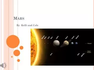
Mars
Mars. The Red Planet. Roman god of war (Greek Ares). Mars. Orbit = 1.524 AU from the Sun Sol = a little over 24hour day (~24hr) Mars year = 1.88 Earth yrs Axial tilt = 25.19 degrees 6,794km diameter (12,756km) Surface gravity = 37.9% of Earths (9.78m/sec 2 )

Mars
E N D
Presentation Transcript
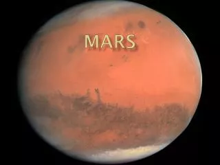
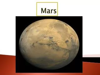
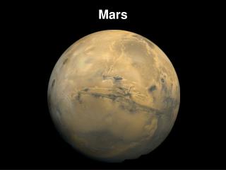
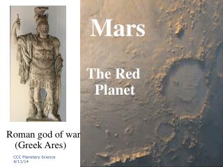
Mars The Red Planet Roman god of war (Greek Ares)
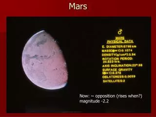
Mars Orbit = 1.524 AU from the Sun Sol = a little over 24hour day (~24hr) Mars year = 1.88 Earth yrs Axial tilt = 25.19 degrees 6,794km diameter (12,756km) Surface gravity = 37.9% of Earths (9.78m/sec2) 100lbs on Earth = 37.7 on Mars 95% CO2 atmosphere 2.7% N 1.6% Ar 0.13% O CO2 annual ice caps Too cold for water to exist as a liquid H2O ice forms the permanent polar caps Large geomorphic features for a planet its size Significant amounts of Fe-oxide = reddish tint CCC Planetary Science 2014
Mars No active magnetic field Relic field and polar reversals locked in volcanic rocks at surface Interior should have cooled completely by now Area of surface almost the same as the area surface of continental land masses on Earth Aeolian processes dominate the surface today Volume of water in polar caps could flood entire planets surface to a depth > 11m CCC Planetary Science 2014
Mars/Ares Moons • An artists rendering of Mars with its two moons Diemos (Terror & Dread) and Phobos (Panic & Fear) • Sons of Ares and Aphrodite • Very small & irregular in shape • Believed to be asteroids captured by Mars gravitational pull CCC Planetary Science 2014
Martian MoonsPhobos Stickney Crater is large feature on left of image Phobos is only 28 by 20 km, so the moon must have been nearly shattered from the force of the impact Grooves that extend across the surface from Stickney appear to be surface fractures caused by the impact Below geosynchonous orbit so doomed to impact Mars ~50my May be fragment from large impact on Mars USGS Astrogeology Program 4/30/04
Martian MoonsDeimos Measuring 16 by 12 km (10 by 7.5 mi) Deimos circles Mars every 30 hours Note surface contrast between Phobos & Deimos CCC Planetary Science 2014
Hemispheric Dichotomy Borealis Basin Largest impact feature in SS? Younger N hemi crust vs older S hemi crust Significant elevation diff between N (left)& S (right) hemi’s
Tharsis Region Vast volcanic plateau Largest topo feature after hemispheric dichotomy 5,000km across & 7km high Indefinite boundaries but ~25% of surface area Largest volcanoes in the SS Olympus Mons is not a part of the Tharsis region Tharsis Montes Arsia Mons Pavonis Mons Ascraeus Mons
Tharsis Bulge • ~300 million km3 of igneous material • CO2 & water vapor from these eruptions could have produced a 1.5-bar CO2 atmos & global layer of water 120m deep • Weight depresses crust around uplift area
Arsia Mons 435km (270 mi) diameter 19.2kms high >9 kms higher than the surrounding plains Shield volcano Summit caldera is 110km wide ~30 times the volume of Mauna Loa in Hawaii Possible glacial activity Collapsed lava tubes / series of small shields across caldera
Pavonis Mons Smallest of the Tharsis Montes volcanoes 375km across 14km above Mars' mean surface level Shield volcano Flank slopes aver only 4° Summit caldera 47 km in diameter & ~5km deep Concentric tensional faulting Glacial evidence Tensional faulting Grabens Pit chains
Ascraeus Mons 480km in diam 2nd highest mountain on Mars Elev 18.1km Shield volcano Flank slope of 7° Complex caldera system Volcanic vents on NE & SW sources for broad lava flows that bury nearby portions of the volcano and extend over 100 km out into the surrounding plains The SW-NE orientation of flows = orientation of Tharsis Montes Suggests major rift is responsible for orientation of flows & Tharsis Montes chain Glacial terminal moraines?
Mars Interior Current knowledge of the interior of Mars suggests a thin crust, similar to Earth's, a mantle and a core If dense (composed of iron) similar to Earth's or SNC meteorites then minimum core radius ~1300 km If less-dense material (e.g. mixture of sulfur and iron) maximum radius <2000 km No liquid layer = no magnetic field CCC Planetary Science 2014
Mars Interior (cont’d) Simulation of processes in the interior of Mars that could have produced the Tharsis region Color differences are variations in temperature Hot regions are red and cold regions are blue and green This type of mantle flow produces plate tectonics on Earth CCC Planetary Science 2014
Mars Geology Olympus Mons largest volcano in the Solar System is 16mi high and 360mi across (about the size of Arizona) It is rimmed by a 4 mi high scarp. A caldera 50 mi wide is located at the summit To compare, the largest volcano on Earth is Mauna Loa. Mauna Loa is a shield volcano 6.3 mi high and 75 mi across The volume of Olympus Mons is about 100 times larger than that of Mauna Loa The entire chain of Hawaiian islands (from Kauai to Hawaii) would fit inside Olympus Mons CCC Planetary Science 2014
Mars Geology Valles Marineris is 2500 mi long and reaches depths of up to 4 mi For comparison, the Grand Canyon in Arizona is about 500 mi long and 1 mi deep The extent of Valles Marineris is as long as the United States and it spans about 20 percent (1/5) of the entire distance around Mars Valles Marineris is a large tectonic "crack" in the Martian crust, forming as the planet cooled, affected by the rising crust in the Tharsis region to the west, and widened by erosional forces Near the eastern flanks of the rift there appear to be some channels that may have been formed by water Valles Marineris CCC Planetary Science 2014
Mars Geology Apollinaris Patera shows characteristics of an explosive origin and an effusive origin Incised valleys in most of the flanks indicates ash deposits and an explosive origin West side landslides also indicate ash deposits South, a large fan of material flowed out of the volcano Indicates an effusive origin The early development of Apollinaris Patera had an explosive origin with subsequent effusive eruptions CCC Planetary Science 2014
Mass Movement/Landslides Ophir Chasma is a large west-northwest-trending trough about 100 km wide The Chasma is bordered by 4 km high walled cliffs, most likely faults, that show spur-and-gully morphology and smooth sections The walls have been dissected by landslides forming reentrants; one area (upper left) on the north wall shows a young landslide about 100 km wide The volume of the landslide debris is more than 1000 times greater than that from the May 18, 1980 debris avalanche from Mount St. Helens USGS Astrogeology Program 4/11/13
Aeolian Activity MOC observes streaks caused by dust devils Thousands of MOC images show these streaks Dozens show they change over time Far fewer images have actually captured a dust devil in the act of creating a streak This crater (above right) is in western Terra Meridiani Dust devil moved toward NE Dark trail is where surficial dust was removed as dust devil advanced CCC Planetary Science 2014
Martian Dust Devil Tracks • Winds remove red dust exposing dark substrate • Sometimes remove CO2 frost exposing dark substrate • Don’t exhibit same consistency in track orientation as on Earth • Sometimes clean off solar panels on rovers extending lifetime of robots and mission CCC Planetary Science 2014
Aeolian Features Some Martian sand dunes may be more active than others Wind has caused the dark and somewhat crescent-shaped dunes to advance toward the lower left Oddly, these dark dunes have moved across and partly cover sets of smaller, bright ridges that also formed by wind action CCC Planetary Science 2014
Aeolian Activity Top image: a martian north polar dust storm observed on 29 Aug. 2000 Storm moved as a front, outward from a central "jet," and marginal "vortices" can be seen It extends about 560 mi out from the north polar seasonal frost cap Bottom image: a terrestrial dust storm, seen by SeaWiFS, on 26 Feb. 2000 Storm extends about 1100 mi off the coast of northwest Africa near the Earth's equator Both images are shown at the same scale; 2.5 mi per pixel CCC Planetary Science 2014
Mars Clouds Pink stratus clouds from NE at ~15mph at an approximate height of ten miles above the surface Clouds consist of water ice condensed on reddish dust particles suspended in the atmosphere Martian atmosphere is highly mobile ~30% of the atmosphere migrates from pole to pole following seasonal transitions CO2 condenses to form seasonal caps of frost during winter months CO2 snowstorms have been identified using thermal TES data Frost could be up to several meters thick CCC Planetary Science 2014
Mars Polar Cap As on the Earth, many severe storms brew in the Martian polar regions Temperature contrasts between the CO2 seasonal frost cap and the warm ground adjacent to it--combined with a flow of cool polar air off the cap--sweeps up dust and funnels it into swirling dust storms along the cap edge The dust storms shown here were observed during the recent northern spring by the MGS MOC in May 2002 USGS Astrogeology Program 4/30/04
Mars: Polar Caps Martian Seasons Winter Polar Cap of dry Ice North Polar Cap: Water Ice South Polar Cap: Dry Ice covering a water ice cap CCC Planetary Science 2014
Polar Layered Terrain Martian north polar cap Layering is result of wind born dust settling upon the polar cap interbedded with CO2 frost Dust layers tend to thicken near the poles where ice deposits remain for longer periods of time Thickness of deposits indicate they formed during cyclical climatic variation rather than annual changes USGS Astrogeology Program 4/30/04 CCC Planetary Science 2014
Patterned Ground Some impact craters on the northern plains of Mars exhibit polygonal patterns on their floors Similar features are common in Arctic and Antarctic on Earth, usually indicate the presence, and freeze-thaw cycles, of subsurface ice USGS Astrogeology Program 4/30/04 CCC Planetary Science 2014
Fluvial Features Originally interpreted to be fluvial processes that carved the channels to the N and E of the Valles Marineris canyon system recent studies suggest a possible volcanic origin for these erosional/depositional features Tremendous erosive power shaped streamlined islands where fluid encountered obstacles along its path Two lee-side, streamlined islands formed by diversion around two 5-6 mile diameter craters within the channel proper The fluid flowed from south to north (bottom to top of the image) USGS Astrogeology Program 4/30/04
Drainage Patterns Many drainage systems on Mars show a resemblance to drainage systems on Earth Dendritic pattern seen here is common on Earth as water flows down topography on rock units of similar strength The Martian examples lack small-scale streams feeding into the larger valleys Absence of small-scale tributaries in Martian valley networks suggests they were carved primarily by ground water flow rather than by runoff of rain Their presence may indicate Mars once possessed a warmer and wetter climate in its early history USGS Astrogeology Program 4/11/13
Gullies Typically occur in areas that are quite cold--well below freezing--all year round Nearly all form on slopes that face away from sunlight (N facing) Locations of the tops of the channels on this slope infer liquid seepage is located at a layer in the pit wall about 1/3 of the way down from the top of the MOC image Gully landforms proposed to have been caused by geologically-recent seepage and runoff of liquid water on Mars are found in the most unlikely places CCC Planetary Science 2014
Mars Exploration Rovers A view looking down from the pan-cameras atop Spirit’s mast, as it sits on the platform just after landing Note the solar panels are still folded from the journey to Mars It was several days before the rover rolled off the platform to begin its journey across the martian terrain CCC Planetary Science 2014
MER (cont’d) Image by Mars Exploration Rover Opportunity's panoramic camera showing impressions left by the rover's airbags as it came to rest in crater Drag marks (bottom) were made after the rover successfully landed at Meridiani Planum and its airbags were retracted Morphology of impressions suggest sudden melting of small amounts of water under compression leaving mud-like traces in soil CCC Planetary Science 2014
MER (cont’d) Spirit takes a look back after leaving the platform base it arrived at Mars on The partially deflated bags used to softened the impacts of landing can be seen around the platform edge and have been stained by the reddish soil of the landing site CCC Planetary Science 2014
MER (cont’d) Front haz-cam image shows the rover's robotic arm, or IDD This is the first use of the arm to deploy the Microscopic Imager (MI), one of four geological instruments located on the arm The MI, APXS, mini-TES and Mossbaur instruments will help analyze and understand martian rocks and soils by taking very high res, close-up images, and acquiring images and data to identify mineralogy and elemental composition CCC Planetary Science 2014
MER (cont’d) The IDD sits poised in front of a rock nicknamed Adirondack, the rover's first science target In preparation for grinding into Adirondack, Spirit cleaned off a portion of the rock's surface with a stainless steel brush located on its rock abrasion tool (RAT) CCC Planetary Science 2014
MER (cont’d) 3-D anaglyph showing a microscopic image taken of soil featuring round, blueberry-shaped spherules on the crater floor at Meridiani Planum These spherules were formed post-depositionally and indicate the presence of solutions (water) in the sediments Spherules are composed mainly of hematite, an FE bearing mineral associated w/water deposition on Earth (BIF’s) Image area is approximately 1.2 inches across CCC Planetary Science 2014
MEROpportunity at Victoria Crater Opportunity’s odometer has passed 10km (6mi) Opportunity is carefully examining best way into crater Probably where it will remain Perhaps the first look at crater dune field Deep enough to examine several layers during its descent CCC Planetary Science 2014
MERVictoria Crater Panorama Opportunity captured vista of "Victoria Crater" from the viewpoint of "Cape Verde," one of the promontories that are part of the scalloped rim of the crater Opportunity drove onto Cape Verde shortly after arriving at the rim of Victoria in September 2006 This view combines hundreds of exposures taken by the rover's panoramic camera (Pancam) CCC Planetary Science 2014
MER todayOpportunity heads into Victoria Crater CCC Planetary Science 2014
MER today A layer of light-toned rock (Cape St. Vincent) exposed inside Victoria Crater in the Meridiani Planum region of Mars appears to mark the ancient surface during the cratering event Investigations suggest the bright band of rock delineates an ancient water table surface USGS Astrogeology Program 4/30/04 CCC Planetary Science 2014
MER Hazard Avoidance Software Upgrades were part of new onboard software uploaded from Earth in 2006 Field D-Star and several other features of autonomy, including visual odometry track the rover's actual position after each segment of a drive Combination of information from two sets of stereo images to consider a wide swath of terrain in analyzing route USGS Astrogeology Program 4/30/04 CCC Planetary Science 2014
Victoria Crater • Cape St. Mary • Classic x-bedded sandstones • Dune migration USGS Astrogeology Program 4/11/14
MERSpirit at Home Plate Spirit continues wintering at angle to maximize suns energy on solar panels Revisiting an area of intriguing and possibly volcanic origin Continues monitoring surrounding terrain and atmospheric phenomenon like this dust devil CCC Planetary Science 2014
The changing face of Mars Ever since the first low resolution image of the Face on Mars there has been speculation about is origin Comparison of higher resolution MOC images to the original Viking image should put the debate to rest Images demonstrate how resolution, sun angle, albedo can change the appearance of a feature CCC Planetary Science 2014