Download
1 / 66
660 likes | 681 Vues
Explore the comprehensive analysis of wind resources off New Jersey's coast for offshore wind energy development as per state renewable goals and regulations. Detailed studies on avian species, fisheries, marine mammals, and more. Cutting-edge technology and data integration for wind power statistics and ecological assessment.

E N D
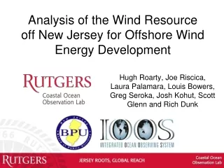
Analysis of the Wind Resource off New Jersey for Offshore Wind Energy Development Hugh Roarty, Joe Riscica, Laura Palamara, Louis Bowers, Greg Seroka, Josh Kohut, Scott Glenn and Rich Dunk
New Jersey Renewable Goals • 23% of its energy from renewable sources by 2021 • The nation’s first offshore wind renewable energy standard which requires at least 1,100 megawatts (MW) by 2021 • Currently at 0.0 MW
State of New Jersey New Jersey Board of Public Utilities (NJBPU) An Advanced Atmosphere/Ocean Assessment Program: Reducing the Risks Associated with Offshore Wind EnergyDevelopment As Defined by The NJ Energy Master Plan and The NJ Offshore Wind Energy Economic Development Act Principal Investigators: Dr. Scott Glenn and Dr. Rich Dunk, CCM Team Members: Dr. Josh Kohut, Dr. Hugh Roarty, Louis Bowers, Greg Seroka, John Kerfoot, Laura Palamara, Mike Crowley, Ethan Handel, Colin Evans New Ocean Data Hi-Res Weather Model Spatial Validation Data Wind Power Statistics
Ecological baseline studies of offshore wind power already performed (shown to left) • Avian species • Fisheries • Marine Mammals • Sea turtles • This project is the physical baseline study
Rutgers University - Coastal Ocean Observation Lab Operations, Research & Education Center Vessels - Satellite Satellite CODAR Ships/ Vessels Glider REMUS Data Vis. Modeling Security Leadership Education Glider Fleet Satellite Data Acquisition Stations CODAR Network 3-D Forecasts
CODAR Compact HF Radar Antennas 25 MHz 13 MHz 5 MHz Separate Transmitter & Receiver Combined Transmitter & Receiver
Shed and Enclosures monitor computer & external hard drive A.C. unit UPS system transmitter receiver Two lines of Communication Shed Enclosure Lightning Protection
Surface Current Mapping Capability 25 MHz Radar l: 12 m Ocean l: 6 m Range: 30 km Resolution: 1 km 13 MHz Radar l: 23 m Ocean l: 12 m Range: 80 km Resolution: 3 km 05 MHz Radar l: 60m Ocean l: 30 m Range: 180 km Resolution: 6 km
HF Radar Derived Linear Wind Model Current Transient [U'] (cm/s) Wind Transient [W'] (cm/s) • Rotate wind vectors according to complex correlation • Calculate the slope and intercept of best fit line U'c(x,y,t) = slope(x,y)*W'(t)
HF Radar CoverageJanuary 23 to May 7, 2012 NDBC or WeatherFlow Wind Record HF Radar Grid Point With at Least 70% temporal coverage
Buoy 44025 Winds (m/s) CODAR Currents (cm/s)
September 12, 2012 Sea Breeze Event Spatial Comparison
Sep 12, 2012 05:00 UTC Land Breeze Starts
Sep 12, 2012 13:00 UTC Wind Direction Eastern Edge of the Land Breeze
Sep 12, 2012 14:00 UTC Winds rotate clockwise
Sep 12, 2012 16:00 UTC Sea Breeze Starts
Sep 12, 2012 19:00 UTC Winds from the Southeast
Sep 12, 2012 00:00 UTC Detided Current Field
Sep 12, 2012 01:00 UTC Detided Current Field
Sep 12, 2012 02:00 UTC Detided Current Field
Sep 12, 2012 03:00 UTC Detided Current Field
Sep 12, 2012 04:00 UTC Detided Current Field
Sep 12, 2012 05:00 UTC Land Breeze Starts Detided Current Field
Sep 12, 2012 06:00 UTC Detided Current Field
Sep 12, 2012 07:00 UTC Detided Current Field
Sep 12, 2012 08:00 UTC Detided Current Field
Sep 12, 2012 09:00 UTC Detided Current Field