Download

1 / 6
60 likes | 125 Vues
Learn about State Drainage Guides for proper crop drainage maintenance to enhance production and meet wetland hydrology criteria. Includes soil properties and drainage recommendations.

E N D
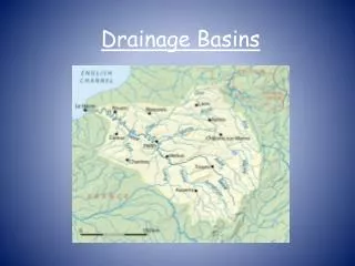
State Drainage Guides How many of you know if you have a State Drainage Guide?
State Drainage Guides- States drainage guides provide information on the proper drain spacing (both surface and subsurface) to provide adequate drainage for crop production (removal of 0.25 to 1” per day).- Drainage guides establish drainage system spacing requirements based upon the type of system, removal rate, and soil type.- FOR WETLANDS: it is reasoned that if a site has a drainage system in proper functioning condition (maintained) that meets the drainage guide criteria, then the hydrology of the site has been removed sufficiently to no longer meet the wetland hydrology criteria.-This reasoning relates to areas affected by water tables, not to those areas subjected to surface inundation by out-of-bank or backwater flooding (ex. Farmed Wetlands that are not a playa, pothole or pocossin).
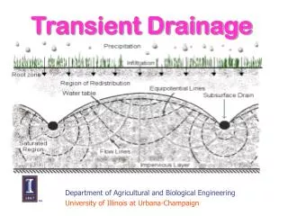
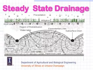
State Drainage Guides- developed based upon information in “Drainage of Agricultural Land”, NEH, Section 16 - Ellipse equation - modified Ellipse equation Hooghoudt’s procedure, “equivalent depth”
Drainage Guide Recommendations Mississippi Series: COMMERCE Estimated Soil Properties ============================================================ Depth USDA Texture Permeability Bedrock (in) ----------------------------------------- (in/hr) (in) 0-10 SL 2.0-6.0 >60 10-36 SIL SICL 0.2-0.6 36-60 SR SIL SICL 0.2-2.0 Flooding: Duration = N/A, frequency = rare, month = N/A High Water Table: depth (ft) = 1.5-4.0, month = Dec-Apr Sub-Surface Design Recommendations ============================================================ Avg. Landuse Drainage Depth Spacing Land Coef. (ft) (ft) Slope (in/day) Min Max Min Max 0-1 Cropland 3/8 36 48 70 90Design Comments: May be suitable for subirrigation
Drainage Guide Recommendations Mississippi Series: ALLIGATOR Estimated Soil Properties ============================================================ Depth USDA Texture Permeability Bedrock (in) ----------------------------------------- (in/hr) (in) 0-5 SIL 0.6-2.0 >60 0-5 SICL 0.6-2.0 0-5 SIC C <0.06 5-52 SIC C <0.06 52-66 SICL SIC C <0.06 Flooding: Duration = brief to long, frequency = rare to common, month = Jan-Apr High Water Table: depth (ft) = 0.5-2.0, month = Jan-Apr Sub-Surface Drain Recommendations =========================================================== Avg. Landuse Drainage Depth SpacingLand Coef. (ft) (ft) Slope (in/day) Min Max Min Max 0-2 Cropland 3/8 30 42 50 70 Design Comments: Because of this clay’s inability to release water at desirable rates, subsurface drainage needs special considerations.
State Drainage GuideSample Lines • Sample Line from Minn. Drainage Guide: for Optimal Crop ProductionSpacing Soil Name ID No. Drain Depth1/4” 3/8” 1/2” 3/4” Glencoe MN0026 36”95’ 73’ 61’ 46’ 48” 124’ 98’ 83’ 65’ • Sample Line from Minn. Drainage Guide for Lateral Effect Distances: Using Criteria from NFSAM Second Edition and Hooghoudt Equation Lateral Effect for Drain Tile at Given Depth Soil NameID No. 24” 36” 48” 60” Glencoe MN0026 32’ 63’ 84’ 100’ S = 2Le Equivalent Spacing for Wetland hydrology 64’ 126’ 168’ 200’