Development of the Controlled Assessment task for 2015
270 likes | 393 Vues
This document outlines the Controlled Assessment task for 2015, focusing on investigating factors influencing river landform formation. Key elements include understanding processes like erosion, deposition, and transportation, with an emphasis on data collection through primary and secondary methods. The assessment encourages students to engage in the enquiry process, develop investigation questions, and analyze landform characteristics such as meanders, V-shaped valleys, and more. Diverse fieldwork techniques and appropriate data mapping strategies are also discussed.

Development of the Controlled Assessment task for 2015
E N D
Presentation Transcript
Development of the Controlled Assessment task for 2015 By: Helen Robertson FSC London 21 October 2013
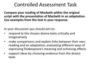
The Task • What’s different? • Making sense of the task statement • The enquiry process • Possible fieldwork techniques (primary & secondary data) • Potential investigations...
Task Information An investigation into factors that affect the formation of river landform(s) • 1.1 What processes are associated with rivers? • 1.2 What landforms result from these processes?
What’s different? • More traditional than 2014 • Not a classic ‘downstream change’ study • Not river management • Focus instead on processes e.g. • Erosion • Deposition • Transportation • Example • meanders
Unpacking the title An investigation into factors that affect the formation of river landform(s) Must include primary data collection. A variety of secondary sources also available . Processes such as erosion, transportation and deposition. Distance downstream as a factor discouraged. Making the link between processes and landforms e.g. How increases in velocity might influence bedload size on a point bar or how the width of the channel may influence meander wavelength etc Meanders, associated features, channel and bankfull dimensions, floodplains, oxbow lakes, V-shaped valleys, waterfalls & gorges.
The enquiry process • Involve the candidates in the enquiry process. • What are they aiming to achieve? – involve candidates in posing enquiry questions • What is the wider geographical concept / theory that is being tested? • How might candidates take some ownership for selecting or collecting data? How will they demonstrate independence?
London’s Lost Rivers http://strangemaps.wordpress.com/2008/06/05/284-londons-lost-rivers/
Some suggestions… • a range of data collection techniques • opportunities for your students to meet the criteria in the mark scheme.
Field sketches and photos • Scope for well annotated photos & sketches. • Combined with mapping to great effect. • Good opportunity to try less traditional ideas e.g. ‘a field sketch from the future or at bankfull discharge’ • Possible use of mobile technology
Mapping of River Landforms • Annotate a base map • Online mapping software e.g. Google Earth, ArcGIS online; sketch map; Scribble maps
Mapping of River Landforms • Hand drawn sketch map • Choropleth landforms • Historical Maps / Images • Geology Maps
The Hjulstrum curve Can processes occurring on a meander be linked to this theory? Straight section vsa meander? Pool vs a riffle? Two sites with same width but a different depth?
Bedload Measurements • Size and angularity assessments
Bedload Measurements • Measuring any sorting of bedload on point bars possible. • Bedloadsize across a cross profile in a straight and meandering channel?
Bankfull measurements • width and depth
Valley profiles, sketches and photos • Link to geology? • Comparison of sides?
Measurements of the landforms • Length and height of river cliffs • Gradients of slip off slopes • Both could be related to variables like water speed or channel width/depth
Measurements of the landforms • Sinuosity = river length/linear distance
Measurements of the landforms • Meander wavelength and amplitude
Does CSA of Bankfull C = CSA of Bankfull A + CSA of Bankfull B C A B
Step pools and comparing gradients • Distance between steps? • Height of steps? • Bedload analysis? • Site important... • Comparison using slope angle possible…
Channel measurements • eg velocity, depth, wetted perimeter, gradient etc • Can still be used.. But not downstream! • Comparison • One or two meander sites? • Compare with past data
Example investigations • Comparison of a meander and a straight channel – channel shape, velocity, bedloadetc • In depth study of a meander – dimensions, velocity, bedload, bankfull and associated features • The effect of channel characteristics on river cliff/point bar size and length • The effect of slope angle on step-pool or pool-riffle characteristics • Channel characteristics & their influence on meander wavelength/sinuosity • Channel A + Channel B = Channel C
Investigation questions • How and why does the shape of the river channel affect the process of deposition? • How and why does the shape of the river channel affect the process of erosion? • How do meanders influence erosion? • How do meanders influence deposition? • The wavelength of a meander is greater where the river channel is wider. • How do meanders influence bedload size and/or shape? • Channel sinuosity increases with increased channel width/discharge. • Length/height of river cliff increases with increased velocity/discharge. Stream gradient influences ‘step-pool’ characteristics.
Questions? • Contact: • Helen Robertson • FSC London • enquiries.ldn@field-studies-council.org • www.field-studies-council.org/london