
Comprehensive Guide to GPS Functions and Flight Procedures
This guide details essential GPS functionalities and procedures for aviation professionals. It covers topics such as fuel calculations, RAIM status, and altimeter settings. Learn how to load approaches into active flight plans, configure navigation settings, and verify critical altimeter and GPS statuses. The guide also includes information on signal strength, satellite data, and holding procedures. This resource is vital for safe and efficient flight operations, ensuring pilots can effectively navigate using GPS technology.

Comprehensive Guide to GPS Functions and Flight Procedures
E N D
Presentation Transcript
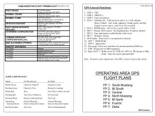
GPS General Functions: 1. OTH 1: FSS 2. OTH 2: ARTCC’s 3. OTH 5: Fuel calculations 4. STA 1: Satellite info: Valid position with 4 or 3 with altitude. Space Vehicle: bad, weak, unknown, blank (good), and fail. Signal to noise ration: mid 30s to 50s is usable. 5. STA 5: RAIM status. Above bar is good, below is bad. 6. SET 3: Nearest APT criteria. Set length/surface of runway desired. 7. SET 6: Turn anticipation enable/disable with cursor. 8. SET 7: Altimeter setting. 9. ALT button: Press twice to accept/mod as desired. 10. APT 7: SIDS/STAR. 11. APT 8: Approaches. 12. Save page: Press save and enter for present position (SAR use). 13. CTR: Waypoints for FIR boundaries. 14. Super NAV 5: Right cursor for VOR-off, APT-on, TK-change to Hdg Scale: Auto left cursor and small dial. Note: To insert a new airport (etc.) into FPL, it goes in above the cursor. OPERATING AREA GPS FLIGHT PLANS FP 1: South Mustang FP 2: BI South FP 3: Central FP 4: North Mustang FP 5: BI North FP 6: Foxtrot FP 7: Delta • ALDIS LAMP SIGNALS: • Signal On The Ground In Flight • Steady Green Cleared to Takeoff Cleared to Land • Flashing Green Cleared to Taxi Return for Landing • Steady Red Stop Give Way to Other Aircraft • Flashing Red Taxi Clear of Runway Do Not Land • Flashing White Return to Starting Point Not Used • Alternating General Warning General Warning • Red and Green Exercise Extreme Caution Exercise Extreme Caution • Red Pyrotechnic Not Used Wave Off Immediately GPS Functions
GPS RVFAC: 1. Load approach into the active flight plan. 2. Select navigation source to GPS. 3. Tune backup TACAN/VOR NAVAIDS. 4. Brief the approach. 5. Verify amber ‘ARM’ within 30nm of the airfield. 6. Press ‘ALT’ to verify altimeter setting. 7. Once on vectors, select ‘OBS’. 8. Select FAWP as the active WPT. 9. Select ‘Super NAV 5/AUTO scale/verify FAWP active’. 10. Twist FAC in the CDI. 11. On vector to final, select ‘LEG’ prior to 3nm from FAWP. 12. Configure to BAC within 5nm of FAWP. 13. At FAWP, conduct 6T’s, verify 3 green ‘GPS/ACTV/LEG’ If missed approach: Select ‘Direct’, verify MAWP, ‘Enter’ GPS Procedure Turn Approach: 1. Load approach into the active flight plan 2. Select navigation source to GPS 3. Tune backup TACAN/VOR NAVAIDS 4. Brief the approach 5. Verify amber ‘ARM’ within 30nm of the airfield 6. Press ‘ALT’ to verify altimeter setting 7. Select ‘OBS’: - prior to the IAF if the IAF&FAF are co-located - after the IAF but prior to FAF if the IAF&FAF are not co-located 8. Conduct 6T’s at IAF 9. At the end of two minutes, execute the 45/180 reversal 10. Once established with FAC intercept, select ‘LEG’ prior to 3nm from FAWP, twist FAC, configure to BAC 11. Select ‘Super NAV 5/AUTO scale/verify FAWP active’ 12. At FAWP, conduct 6T’s, verify 3 green ‘GPS/ACTV/LEG’ If missed approach: Select ‘Direct’, verify MAWP, ‘Enter’ GPS Arcing Approach or ‘Basic T’ Approach: 1. Load approach into the active flight plan 2. Select navigation source to GPS 3. Tune backup TACAN/VOR NAVAIDS 4. Brief the approach 5. Verify amber ‘ARM’ within 30nm of the airfield 6. Select ‘Super NAV 5/AUTO scale’ 7. Press ‘ALT’ to verify altimeter setting 8. Select ‘LEG’ prior to the IAF 9. Conduct 6T’s at IAF 10. Once established on the arc or approach leg, twist desired track into the CDI, configure to BAC within 5nm of FAWP 11. Once on FAC, verify FAWP active 12. At FAWP, conduct 6T’s, verify 3 green ‘GPS/ACTV/LEG’ If missed approach: Select ‘Direct’, verify MAWP, ‘Enter’ GPS Holding: 1. Select navigation source to GPS 2. Select holding fix as the active WPT - select ‘LEG’ en-route to the holding fix - select ‘OBS’ prior to the holding fix and center CDI needle 3. Determine proper holding entry procedure 4. Conduct 6T’s at holding fix 5. At the end of outbound timing or distance, tail-radial-turn 6. Upon reaching holding fix commence No-Wind Orbit 7. At the end of outbound timing or distance, tail-radial-turn 8. When wings level start timing if required and determine wind direction, tail-radial-wind, and number of degrees off the the holding course 9. Upon reaching holding fix commence Correction Orbit GPS Procedures GPS Procedures