Download

1 / 12
120 likes | 277 Vues
River Systems: A Force Of Nature. Chapter 12. Why are Rivers Important?. Rivers have a very important function: they are Earth’s lifeblood. Although 70% of Earth’s surface is covered with water, almost all of it is the salt water found in oceans.

E N D
River Systems: A Force Of Nature Chapter 12
Why are Rivers Important? Rivers have a very important function: they are Earth’s lifeblood. Although 70% of Earth’s surface is covered with water, almost all of it is the salt water found in oceans. Rivers provide us with fresh water, which is vital to life. Approximately 1250 cubic kilometers of fresh water flow through Earth’s rivers. Fresh water comes from a water cycle .
Water Cycle • The first stage of the water cycle is evaporation. • Second is condensation. • The third stage is precipitation. • Every time there is precipitation, it falls directly into the river or it moves along the surface or underground
Parts of a River • Rivers form patterns on the Earth as they act as passageways for water to move from higher to lower ground. • The end of a river is called a mouth. • Following the river upstream, it becomes smaller and smaller. • The upstream end of the river is called the source. • The source might be a small pond, a lake, a swamp, a slowly-melting glacier, or a spring flowing from deep within the Earth.
Parts of River (cont.) • A river gradually grows larger and larger as it is joined by tributaries. • These are smaller rivers or creeks that drain water from the surrounding land to the main river. • A river system is made up of all parts of a main river as well as all the interconnecting smaller rivers and streams. • The entire area of land that is drained by one river system is known as a drainage basin. • a drainage basin will contain several smaller basins.
River Flow Patterns Climate and landform are two factors that determine the flow of rivers. In some areas of the world, rivers dry up when there is not enough precipitation to keep them flowing. Such a river is known as an intermittent river, and is shown on maps as a dotted blue line. Rivers can also change the shape of the Earth’s surface. Fast-flowing rivers pick up gravel, sand, and mud and drop them off in areas where the flow of the river has slowed down. The deposited materials are called sediment. As sediment is deposited, new landforms are created.
Drainage Patterns • River systems have different patterns of drainage, depending on the landform and climate • The dendritic pattern is the most familiar. • The tree-like pattern occurs in regions with a gentle slope, where all the rock structures are the same hardness, causing the rock to erode evenly. • The trellis pattern occurs where the area is a bit flatter • the underlying structure is alternating bands of hard and soft rock • Tributaries wear away soft rock first and leave behind ridges of harder rock • The main river, because it is larger than the tributaries, is able to break through the bands of hard rock to form a main channel.
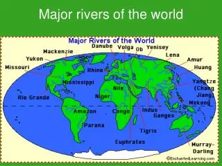
North American Drainage Patterns All rivers in North America drain into either the Pacific Ocean, the Arctic Ocean, Hudson Bay, the Atlantic Ocean , or the Gulf of Mexico The direction of flow depends on the landform, as water drains from highest point to lowest
The Nile River (cont.) The floods made the soil moist and fertile, as rich sediments were carried from the upper areas and deposited in lower areas surrounding farmland The area surrounding the river is mostly desert This made the flooding was very important for human survival To meet the growing demands, farmers dug trenches and canals to irrigate the area that was not reached by the floods
The Aswan High Dam The Egyptians thought it was necessary to control the Nile's flooding, so they could grow crops during the flood season The Aswan Dam was built in 1968 on the Nile River Building it, created Lake Nasser Lake Nasser, provides enough water to irrigate half a million hectors of land Because of lake Nasser, farmers can produce two or more crops a year The lake provides hydroelectricity power to Egypt and Sudan
The Aswan High Dam (cont.) It also has negative aspects The fertile soil piles up behind the dam, instead of fertilizing the fields Farmers have to rely on heavy amounts of chemical fertilizers to improve the soil The Dam affects the delta of the Nile Delta- an area of soil or silt deposits builds up at the mouth of the river
The Aswan High Dam (cont.) The Delta is no longer receiving as much rich sediments as before Salty water from the Mediterranean is starting to invade the river channels Sea water is eroding the land and ruining the farming Changing river system by building a dam or canal brings about serious problems with the natural environment.