
Collaborative GPS Observations for COPS: Enhancing Water Vapor Studies and Network Expansion
E N D
Presentation Transcript
GPS Network for COPS German – French – Swiss Collaboration
GPS observations for COPS Scientific Objectives • Water vapor evolution: IWV fields, Tomography, Lge scale VS Sml scale studies • Investigations on precursors to convective initiation • Input to models for assimilation ? • Case study: validation of model water vapor fields, comparisons with other instruments
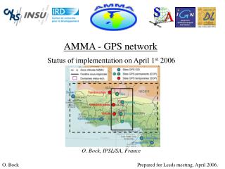
GPS observations for COPS GPS existing networks • SAPOS/GFZ in Germany • AGNES in Switzerland • RGP—TERA—RENAG in France
GPS observations for COPSNew stations deployment ? • GFZ: 5 additional permanent stations black forest
GPS network New GFZ stations ?
GPS observations for COPSNew stations deployment ? • GFZ: 5 additional permanent stations black forest • French temporary network up to 16 stations • Extend the 50 km network towards France and Rhine valley
GPS network French temporary stations ? (large scale)
GPS observations for COPSNew stations deployment ? • GFZ: 5 additional permanent stations black forest • French temporary network up to 16 stations • Extend the 50 km network towards France and Rhine valley • Densify the network around COPS central area -- French supersite -- Rhine valley
GPS network French temporary stations ? (small scale)
GPS observations for COPSCOPS community input ? • Deployment priorities ? • GPS data processing • Processing centers: GFZ + ? • Products needed ? ZTD's, STD's, IWV's, Tomographic fields and profiles • Real time VS Post processing: for which stations and what products
GPS observations for COPSCOPS community input:Comments and Suggestions ?