Download
1 / 18
180 likes | 307 Vues
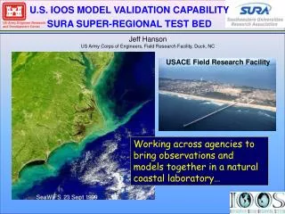
U.S. IOOS MODEL VALIDATION CAPABILITY SURA SUPER-REGIONAL TEST BED. Jeff Hanson US Army Corps of Engineers, Field Research Facility, Duck, NC. USACE Field Research Facility. Working across agencies to bring observations and models together in a natural coastal laboratory….

E N D
U.S. IOOS MODEL VALIDATION CAPABILITY SURA SUPER-REGIONAL TEST BED Jeff Hanson US Army Corps of Engineers, Field Research Facility, Duck, NC USACE Field Research Facility Working across agencies to bring observations and models together in a natural coastal laboratory…
SURA SUPER-REGIONAL TEST BED Don Wright (SURA), Yesterday… Test Bed Goals Develop skill metrics and evaluate model performance… Year 1 Products Skill metrics and identification of key performance factors for test bed modeling regimes…
Inundation Modeling Systems Atmosphere Research Storm Surge Waves Circulation SURA Server Inundation Modeling Test Bed Skill Assessment Concept Regional Observations Analysis Interactive Model Evaluation and Diagnostics System Performance Evaluation Model Diagnostics
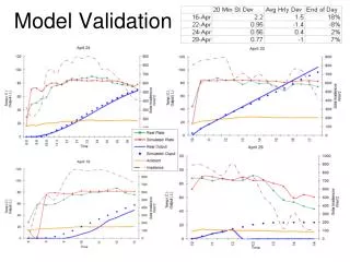
Features • Stand-alone desktop model validation toolkit • Based on published NOAA standards (Hess et. al., 2003; Zhang et.al., 2006). • Robust error metrics: Erms, bias, Scatter Index, Skill Score • Explore model errors as a function of time, space, event, etc. Performance Scores • Performance scores range from 0 to 1 (1 is a perfect match) • Synthesize error metrics across space and time • Normalized to mean observed quantities • A measure of error % relative to mean observed quantities
Parameters Added To-Date Winds Waves(Windsea and swell) Storm Surge Speed, Direction Height, Period, Direction Water level, High water marks Error Metrics Statistical Analyses Coming Soon • RMS Error • Bias, Angular bias • Scatter Index • Circular correlation • Performance (Skill) Scores • Temporal correlation • Quantile-Quantile (distributions) • Peak event (peak over threshold) • Target Plots IMEDS Error Analyses
IMEDS Error Metrics For n pairs of measurement (m) and hindcast (h) data… Bias RMS Error Scatter Index Reference: Hanson, Tracy, Tolman and Scott, 2001. J. Oce. Atms. Tech., 26, 1614-1633
IMEDS Error Metrics And for directional data… Angular Bias Circular Correlation Reference: Hanson, Tracy, Tolman and Scott, 2001. J. Oce. Atms. Tech., 26, 1614-1633
IMEDS Skill Scores Scores are computed relative to mean observed quantities Bias Skill Scores range from 0 to 1 1 = perfect agreement 0 = totally uncorrelated RMS Error Skill Scatter Index Skill Average the 3 scores Station Skill Combine station scores using sample size weights Total Skill
Peak Event Analysis Peak Over Threshold Extraction Peak Event Statistics
FEMA Region III Storm Surge Project Hurricane Isabel Max Water Levels
FEMA Region III Storm Surge Study: Hurricane Isabel September 2003
FEMA Region III Storm Surge Study: Nor’Ida November 2009
Supported Data Formats Model Output Observed Data • NDBC buoys • NODC wind/wave stations • NOS – includes detide option • IMEDS Generic Format • WW3 (*spc) • SWAN (spec2d.out & TAB(opt)) • ADCIRC Water-Level (fort.61) • ADCIRC Wind (fort.72) • Extract from SURA OpenDAP Server (netCDF file) • IMEDS Generic Format
IMEDS Generic Format Sample File % IMEDS generic format version 1.0 – water-elevation % year month day hour min watlev (m) NOS UTC NAVD 8635750 37.9950 76.4650 2009 11 9 0 0 0.2440 2009 11 9 1 0 0.1580 2009 11 9 2 0 0.0530 2009 11 9 3 0 -0.0310 2009 11 9 4 0 -0.1000 5461421 36.8432 73.5591 2009 11 9 6 0 -0.1520 2009 11 9 7 0 -0.0900 2009 11 9 8 0 0.0140 Station Data Station Data
IMEDS Set Up GUI Sample File
Accomplishments to Date • IMEDS posted on SURA Server with illustrated users guide • Develop data interface to SURA OpenDAP server • Implement generic text file interface • User-defined graphics export formats (jpeg, png, fig, etc…) • Prototype Target Plot
Want to use IMEDS? • Download IMEDS from SURA Server • Review fully illustrated users guide • Ensure observation data are in native format (NOS, NODC, etc) or IMEDS Text format • Export model results in IMEDS generic text format • Seek help as needed from CI group and/or USACE • Put IMEDS to work for you!