WP1.2: “ Developing gridded datasets based on long-term remote sensing data (DWD)”
WP1.2: “ Developing gridded datasets based on long-term remote sensing data (DWD)”. Both products use 15-min geostationary satellite observations from SEVIRI/Meteosat. Spatial resolution of data is a few km (depends on latitude/longitude)

WP1.2: “ Developing gridded datasets based on long-term remote sensing data (DWD)”
E N D
Presentation Transcript
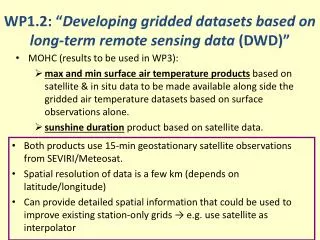
WP1.2: “Developing gridded datasets based on long-term remote sensing data (DWD)” • Both products use 15-min geostationary satellite observations from SEVIRI/Meteosat. • Spatial resolution of data is a few km (depends on latitude/longitude) • Can provide detailed spatial information that could be used to improve existing station-only grids → e.g. use satellite as interpolator • MOHC (results to be used in WP3): • max and min surface air temperature products based on satellite & in situ data to be made available along side the gridded air temperature datasets based on surface observations alone. • sunshine duration product based on satellite data.
Satellite Tmax and Tmin Missing data = no retrieval possible (e.g. persistent cloud) SEVIRI Tmax estimate for 01 July 2009 SYNOPS station Tmax 01 July 2009 Derived from Land Surface Analysis Satellite Applications Facility (LSA SAF) land surface temperatures (LST). Accuracy of daily satellite Tmax/Tmin is ~ 1-3 ºC.
Satellite Sunshine • Derived from Satellite Application Facility to support NoWCasting and very-short-range forecasting (SAFNWC) cloud type data. • Accuracy of daily satellite sunshine duration is better than 1-2 hours over the UK. SEVIRI Sunshine estimate for 01 July 2008 Location of UK sunshine stations
WP 1.1 & 1.3: The international ACRE initiative Rob Allan, Met Office Hadley Centre, Exeter, Devon, United Kingdom QCCCE
What is ACRE? the Queensland Climate Change Centre of Excellence (QCCCE) in Australia the Met Office Hadley Centre in the UK the US National Oceanic and Atmospheric Administration (NOAA) Earth System Research Laboratory (ESRL) and Cooperative Institute for Research in Environmental Sciences (CIRES) at the University of Colorado ACRE is an international collaborative initiative led by a consortium of:
What is ACRE doing & aiming to produce? Undertaking & facilitating the recovery of millions of historical instrumental surface terrestrial & marine global weather observations to fuel successive 4D global weather reconstructions or reanalyses over the last 200-250 years 20th Century Reanalysis Project: 1891-2008 [Autumn 2009] 20th Century Reanalysis Project: 1871-2008 [Autumn 2010] Surface Input Reanalysis for Climate Applications (SIRCA): 1850-2011 [Autumn 2012] Chemical and Surface Input Reanalysis for Climate Applications (CSIRCA): 1800-2016 [Autumn 2017] for global climate research; climate applications, extremes, risks and impacts needs; educators & students, & the general public via a web-based interface that will store, allow free access to, & enable visualisations of, the raw data, data images, meta data through to all of the variables generated by the 4D global weather reanalyses
Who else is involved internationally? With WMO, GEO, GCOS endorsement, wide international support & the aid of various working groups of GCOS and WCRP, ACRE provides an umbrella that links together some 30+ projects, data rescue & climate applications activities around the globe